Glacial Landscapes — OCR GCSE Study Guide
Exam Board: OCR | Level: GCSE
This study guide provides a comprehensive, exam-focused breakdown of UK Glacial Landscapes for OCR GCSE Geography. It explores the powerful physical processes that carved out dramatic scenery in places like the Lake District and Snowdonia, and equips candidates with the skills to analyse these relict landscapes and the human pressures they face today.
## Overview
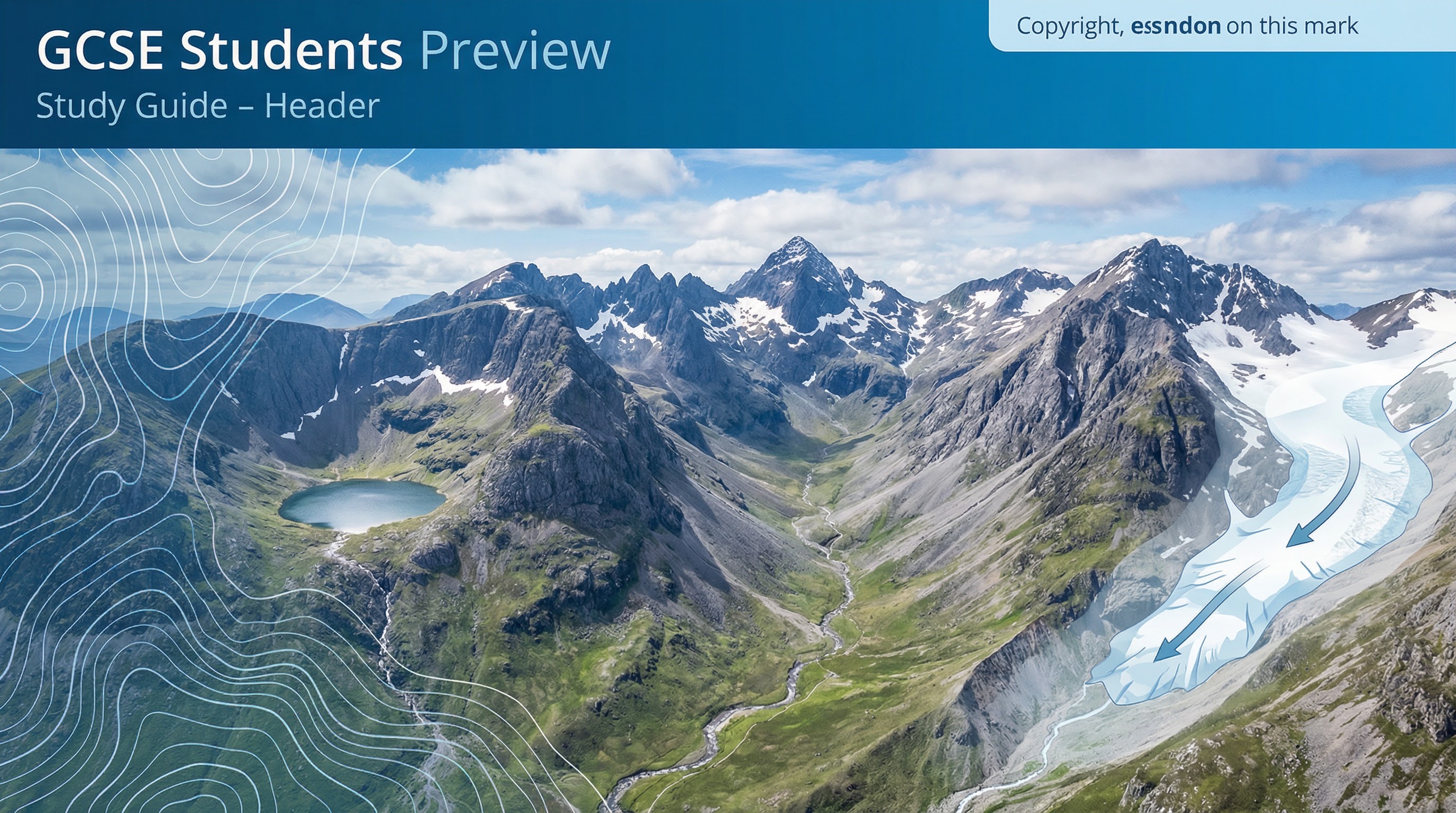
This topic explores the formation of distinctive glaciated landscapes in the United Kingdom, focusing on the legacy of the Pleistocene ice ages. For the OCR examination, candidates are expected to demonstrate a rigorous understanding of the key physical processes of glacial erosion and weathering, the resultant landforms, and the ability to interpret these features on Ordnance Survey (OS) maps. A significant portion of marks are also awarded for evaluating the conflicts that arise from modern human activity in these fragile, relict environments. This guide will provide the specific knowledge required, from the sequencing of geomorphic processes to the analysis of a named UK case study, ensuring you can construct high-level responses that meet the demands of the assessment objectives.
{{asset:glacial_landscapes_podcast.mp3}}
## Key Glacial Processes
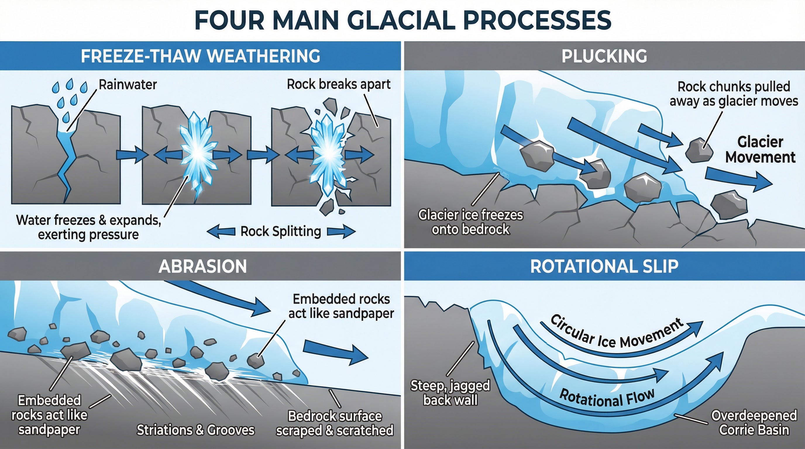
Examiners award significant credit for demonstrating a clear understanding of the sequence and interaction of glacial processes. It is vital to distinguish between weathering (the in-situ breakdown of rock) and erosion (the wearing away and removal of rock by a moving force).
### Freeze-Thaw Weathering
**What happens**: This is a mechanical weathering process. Water enters cracks and joints in the rock. When temperatures drop below 0°C, the water freezes and expands by approximately 9%, exerting immense pressure on the surrounding rock. Repeated cycles of freezing and thawing widen the cracks, eventually causing fragments of rock (scree) to break off.
**Why it matters**: It provides the angular rock fragments that are used by the glacier for abrasion and also contributes to the shattering of rock on arêtes and pyramidal peaks.
### Plucking
**What happens**: As the glacier moves, the pressure can cause basal ice to melt and then refreeze around rock fragments on the valley floor and sides. As the glacier continues its advance, it pulls or 'plucks' these frozen-in fragments away from the bedrock.
**Why it matters**: This is a key erosional process, particularly responsible for steepening the back walls of corries and creating a jagged, rocky landscape.
### Abrasion
**What happens**: This is the 'sandpaper' or scouring effect. The rock fragments embedded in the base and sides of the glacier are dragged over the underlying bedrock, grinding it down. This process smooths the bedrock and can carve long scratches, known as striations, which indicate the direction of ice movement.
**Why it matters**: Abrasion is responsible for the over-deepening of glacial troughs and the characteristic smooth, polished appearance of some rock surfaces (roches moutonnées).
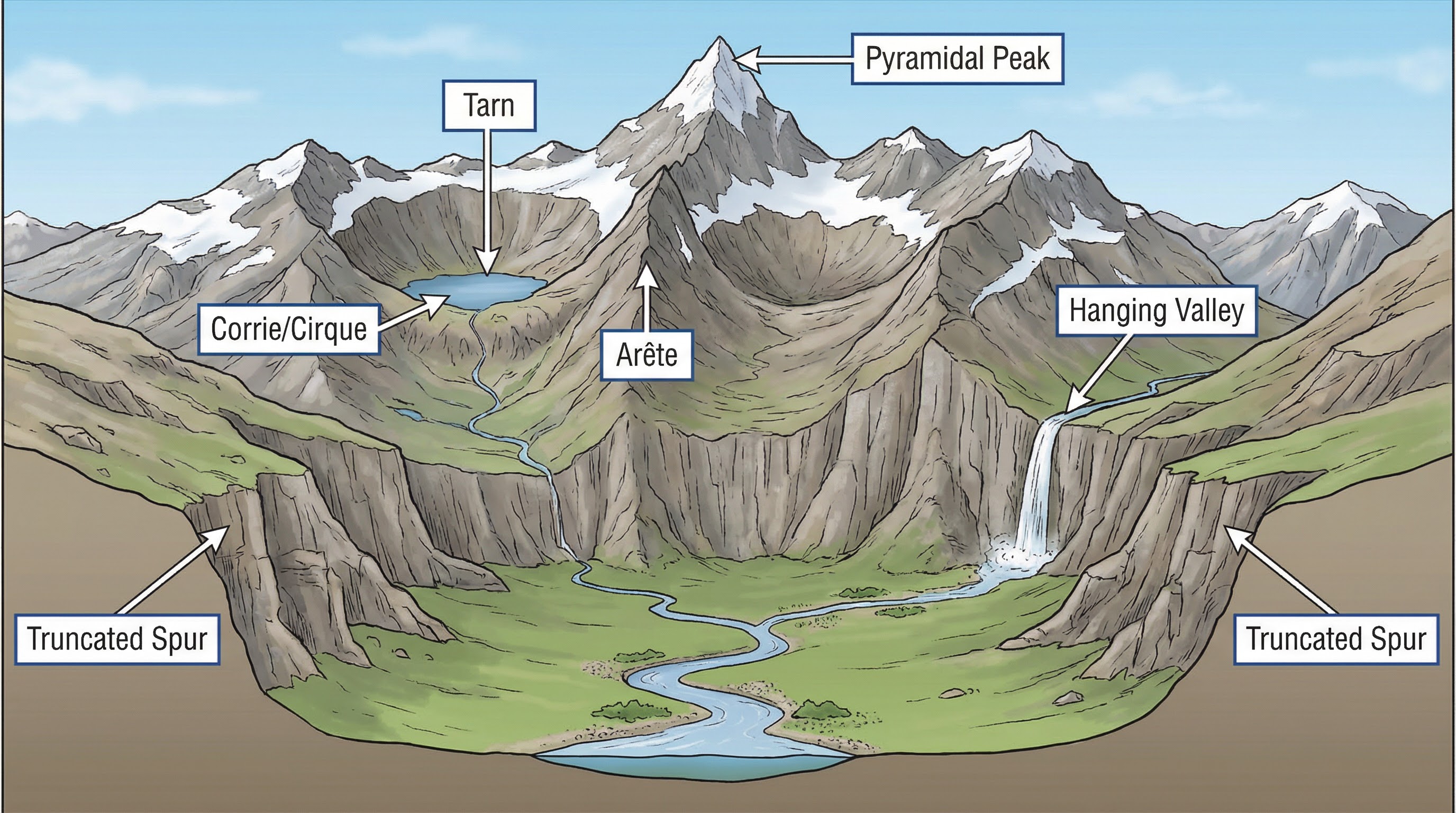
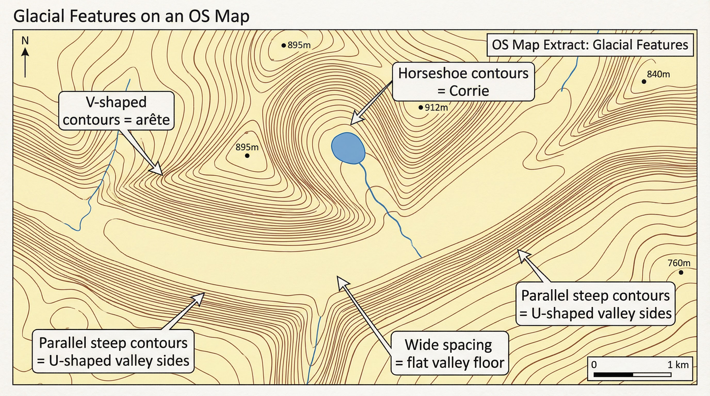
## Erosional Landforms & OS Map Skills
Candidates must be able to identify and explain the formation of a range of erosional landforms, and crucially, recognise their distinctive signatures on an OS map.
| Landform | Formation Process | OS Map Identification |
|---|---|---|
| **Corrie (Cirque)** | Snow accumulates in a hollow, compresses to ice. **Rotational slip** (a circular movement of the ice) deepens the hollow through **abrasion**, while **plucking** and **freeze-thaw** steepen the back wall. A rock lip is often left at the front. | A distinct armchair-shaped hollow with very steep back wall shown by tightly packed, horseshoe-shaped contour lines. A small lake, or **tarn**, may be present, shown as a blue circle. |
| **Arête** | A narrow, knife-edge ridge formed when two corries erode back-to-back. The ridge is sharpened by **freeze-thaw weathering**. | A very narrow ridge with steep slopes on both sides. Contour lines will be very close together, often with spot heights along the crest. |
| **Pyramidal Peak** | A pointed peak formed where three or more corries erode backwards into the same mountain. | A mountain peak with several arêtes leading off it. Indicated by a high spot height and contour lines falling away steeply in multiple directions. |
| **Glacial Trough (U-Shaped Valley)** | A pre-existing river valley is widened and deepened by a powerful valley glacier. The glacier truncates interlocking spurs, creating steep, straight sides and a flat floor. | Very steep sides shown by closely packed, parallel contour lines, with a wide, flat valley floor where contours are very far apart. |
| **Hanging Valley** | A smaller, tributary valley that enters the main glacial trough at a higher level. The smaller glacier had less erosive power than the main glacier. | A smaller valley joining the main trough high up on the side. Often marked by a waterfall where a river now flows over the edge. |
## Case Study: Human Activity in the Lake District
OCR requires a named UK case study of a glaciated upland area to illustrate the conflicts between different land uses and the attempts to manage them.
| Land Use | Economic/Social Benefits | Environmental Conflicts | Management Strategies |
|---|---|---|---|
| **Tourism** | Employs 16,000 people, contributes £1.5bn to the local economy annually. Provides recreation and improves well-being. | 19 million annual visitors cause traffic congestion, footpath erosion (e.g., on Helvellyn), and visual/air pollution. Second-home ownership (20% of properties) prices out locals. | **Fix the Fells**: repairs and maintains mountain paths using stone pitching. **Traffic Management**: Park-and-ride schemes (e.g., in Ambleside), speed limits on Windermere. **Zoning**: National Park Authority designates quiet zones to protect sensitive areas. |
| **Farming** | Traditional sheep farming (e.g., Herdwick sheep) helps maintain the cultural landscape and provides local produce. | Overgrazing can lead to soil erosion. Farm waste and fertilisers can cause water pollution (eutrophication) in lakes. | **Environmental Stewardship Schemes**: Government grants paid to farmers for protecting wildlife habitats, planting trees, and reducing stocking densities. |
| **Forestry** | The Forestry Commission manages large coniferous plantations (e.g., Grizedale Forest) for timber production. Provides employment and recreational opportunities (Go Ape). | Large, non-native conifer plantations can reduce biodiversity and create a uniform, unnatural appearance, impacting the landscape's aesthetic value. | **Sustainable Forest Management**: Felling in smaller blocks, replanting with a mix of native broadleaf species to improve biodiversity and visual appeal. |
| **Water Management** | Thirlmere Reservoir provides water for the city of Manchester. Reservoirs can be used for recreational activities like sailing. | Construction of reservoirs and dams is visually intrusive and floods large areas of farmland and natural habitat. | **Landscape Restoration**: Planting trees and landscaping around reservoirs to help them blend into the environment. Promoting conservation and recreation. |
## Fieldwork Techniques
- **Footpath Erosion Transect**: Use a tape measure and ruler to systematically measure the width and depth of a footpath at regular intervals away from a central point (e.g., a car park) to investigate the impact of tourism.
- **Environmental Quality Survey (EQS)**: Select several sites and score them on a scale (e.g., -3 to +3) for criteria like litter, noise, traffic, and building appearance to assess the impact of human activity.
- **Land Use Mapping**: Walk a designated route and use a base map to shade in different areas according to their primary land use (e.g., tourism, farming, residential).