Pearson Edexcel · A-Level · Geography
Course version: Pearson-A-Level-Geography · Version from Mar 2026
The Water Cycle and Water Insecurity
This study guide covers the vital topic of the global hydrological cycle and the drainage basin system. It explores how water moves across the Earth, how human activities disrupt these natural flows, and why water insecurity is a growing global challenge.
- 5 min read
- 3 worked examples
- 5 practice questions
- 6 key terms
Check what you remember
Read the wording for your board, then hide it and explain Closed System in your own words. Rough notes are fine. This is a self-check, with no mark or grade.
Reference: Pearson Edexcel
A system where energy transfers across boundaries, but matter does not (e.g., the global hydrological cycle).
Study Notes
Overview
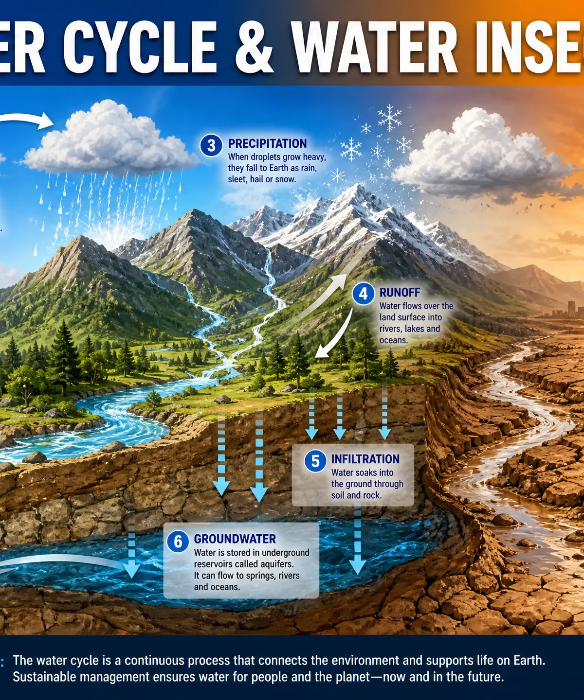
The Water Cycle and Water Insecurity is a foundational topic in GCSE Geography. It explores the journey of water through the global hydrological cycle—a closed system driven by solar and gravitational energy—and the local drainage basin, which operates as an open system. Understanding the distinction between these two systems is critical for examiners. You will also need to grasp how physical factors (like climate and geology) and human activities (like deforestation and urbanisation) influence water movement, river regimes, and storm hydrographs. With climate change and population growth, managing water insecurity is one of the most pressing challenges of the 21st century.
Key Concepts & Systems
The Global Hydrological Cycle
System Type: Closed System
What happens: Water moves continuously between the oceans, atmosphere, cryosphere, biosphere, and lithosphere. No water is added or lost from the Earth as a whole.
Why it matters: It maintains the global balance of water. Understanding residence times (how long water stays in a store) is crucial—for example, groundwater can stay in an aquifer for 10,000 years, making over-abstraction highly unsustainable.
Specific Knowledge:
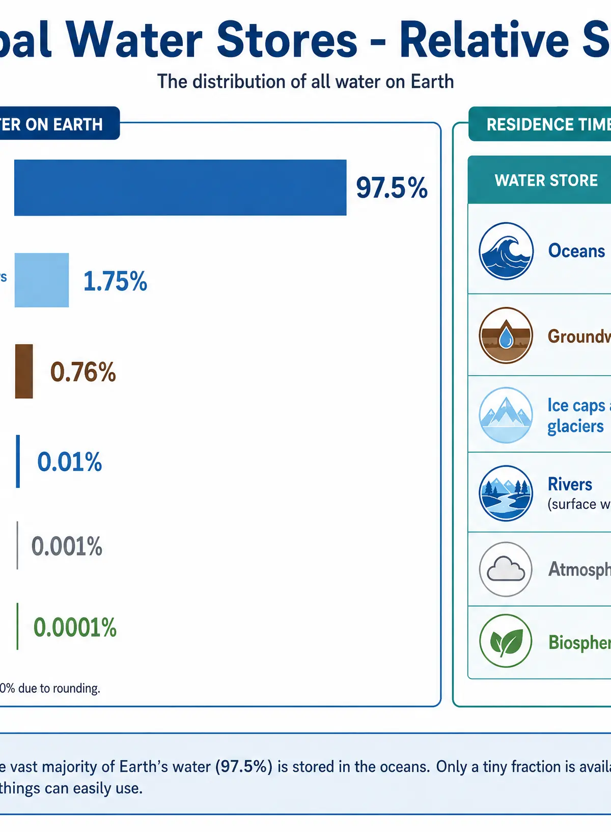
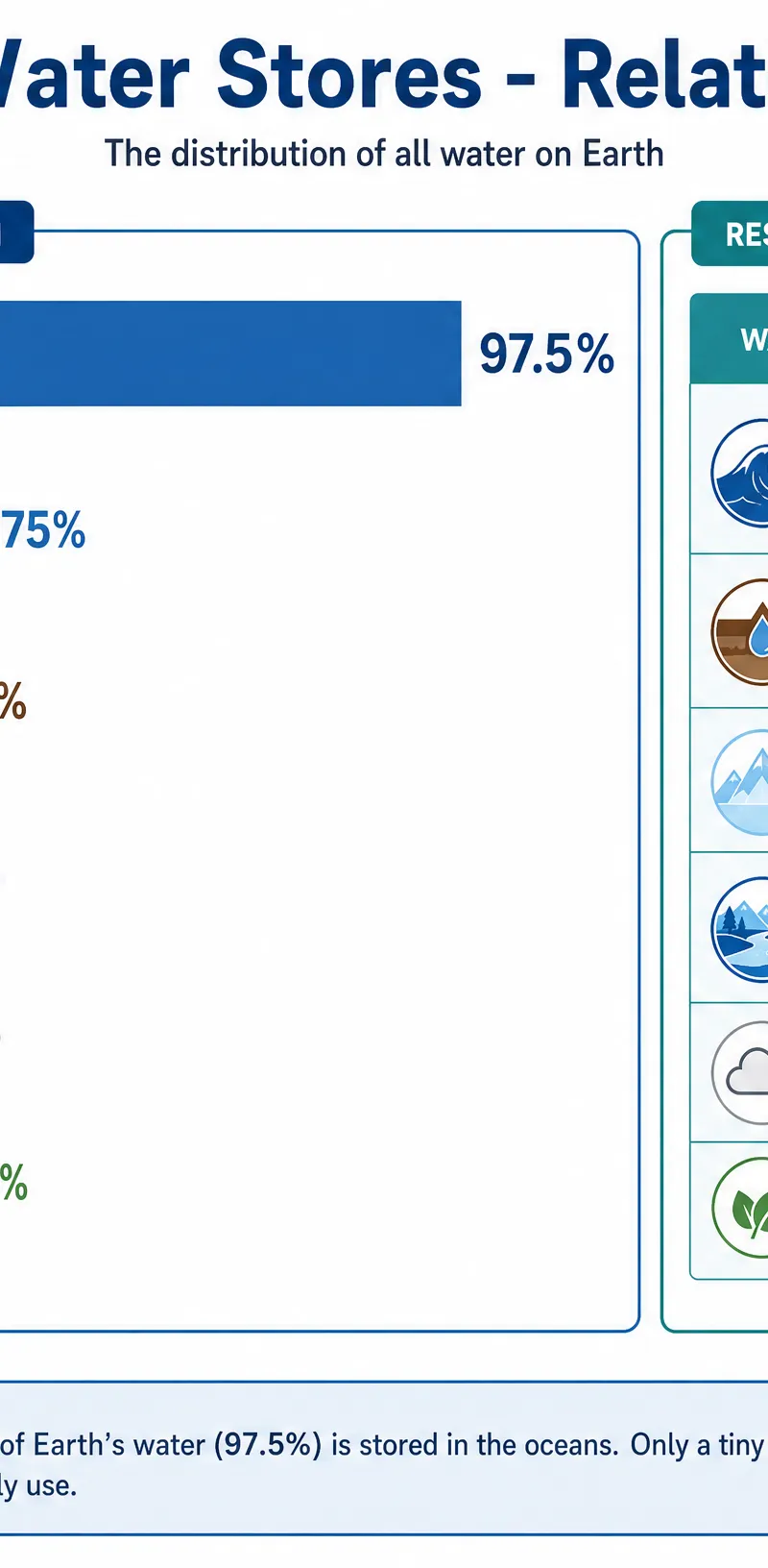
- Oceans hold 97.5% of global water.
- Cryosphere holds ~1.75%.
- Groundwater holds ~0.76%.
- Surface water holds just 0.01%.
The Drainage Basin System
System Type: Open System
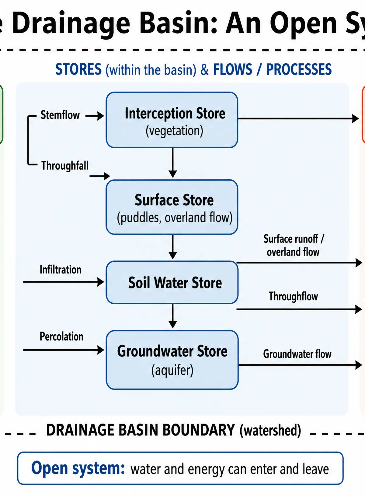
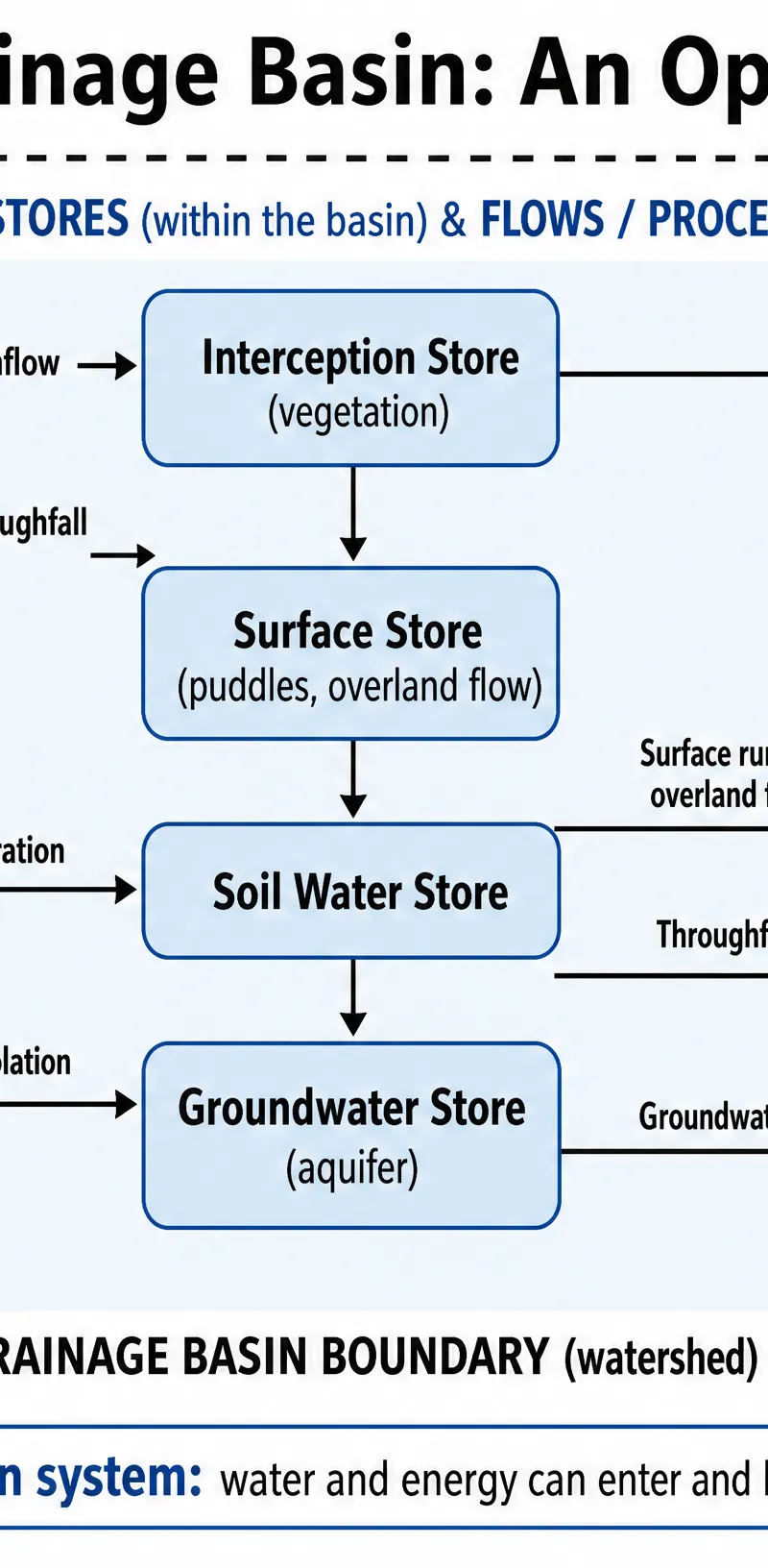
What happens: The area of land drained by a river and its tributaries. Water enters as precipitation (input) and leaves via evapotranspiration and river discharge (outputs).
Why it matters: This is the scale at which local flooding and water management occur. Human activities directly impact the flows within this boundary.
Specific Knowledge: Key stores include interception (vegetation), surface (puddles), soil water, and groundwater. Key flows include stemflow, infiltration, throughflow, percolation, and overland flow.
Human Disruption
Deforestation
Role: Removing trees for agriculture, logging, or settlement.
Key Actions: Reduces the interception store and transpiration. Roots no longer bind the soil, leading to decreased infiltration.
Impact: Increases surface runoff, shortens lag times on hydrographs, and significantly raises the risk of downstream flooding. (Case Study: Amazon Basin).
Urbanisation
Role: Replacing natural land with built environments.
Key Actions: Creates impermeable surfaces (tarmac, concrete) and installs artificial drainage systems.
Impact: Drastically reduces infiltration and increases overland flow. Water reaches the river channel much faster, creating flashy storm hydrographs and increasing urban flood risk.
Second-Order Concepts
Causation
Flooding and water insecurity are rarely caused by a single factor. They result from a combination of physical causes (intense precipitation, impermeable geology, steep relief) and human triggers (urbanisation, deforestation, over-abstraction).
Consequence
Disrupting the water cycle has immediate effects (flash flooding, soil erosion) and long-term consequences (aquifer depletion, desertification, conflict over water resources).
Change & Continuity
While the total volume of water in the global cycle remains constant (continuity), the distribution of that water and the speed at which it moves through drainage basins is rapidly changing due to human interference and climate change.
Significance
Water is the fundamental resource for life, agriculture, and industry. Understanding its movement is essential for sustainable management and mitigating the impacts of droughts and floods.
River Regimes and Storm Hydrographs
River Regimes
A river regime describes the annual variation in a river's discharge. It is influenced by climate (temperature and precipitation patterns), geology, and vegetation. For example, the River Yukon has a massive peak in spring due to snowmelt, while the River Indus peaks in summer due to both snowmelt and monsoon rains.
Storm Hydrographs
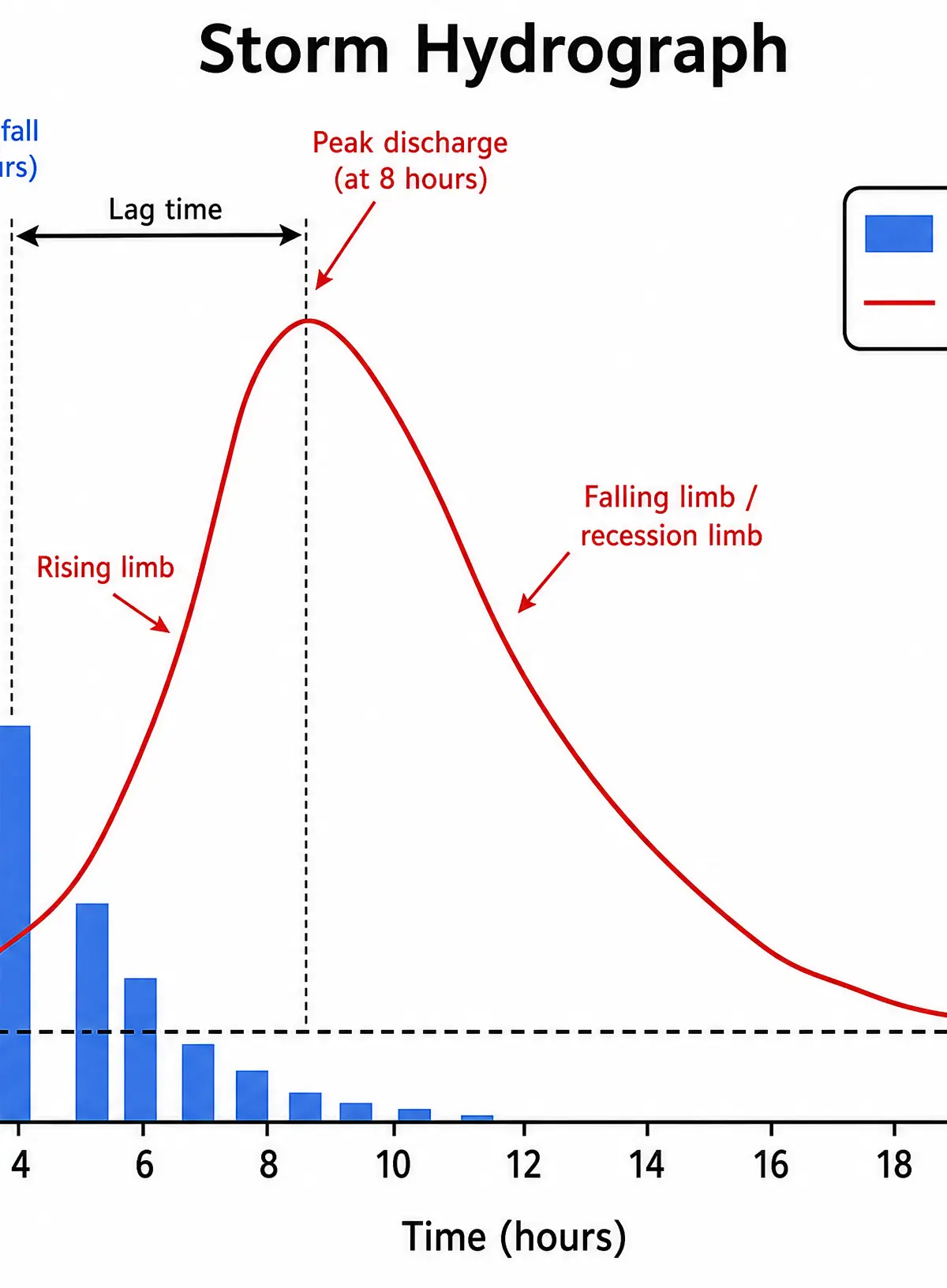
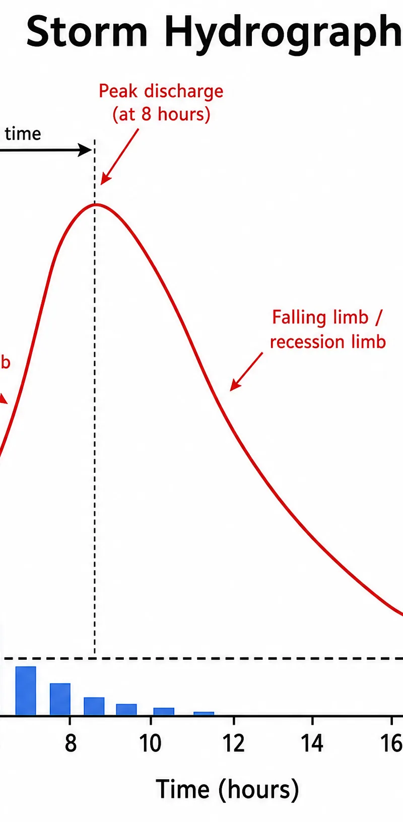
A storm hydrograph shows a river's response to a specific rainfall event.
- Flashy Hydrograph: Short lag time, high peak discharge, steep rising limb. Caused by impermeable rock, steep slopes, heavy rain, and urbanisation.
- Subdued Hydrograph: Long lag time, low peak discharge, gentle rising limb. Caused by permeable rock, gentle slopes, light rain, and forested areas.
Visual Resources
3 diagrams and illustrations
Interactive Diagrams
1 interactive diagram to visualise key concepts
Conceptual Flow Outline
Flowchart showing water movement through a drainage basin
Worked Examples
3 worked examples — open one to explore the question and available guidance.
Practice Questions
Try the question, then reveal an answer plan or example response
Study Figure 1 (a storm hydrograph). Describe the relationship between rainfall and river discharge. (3 marks)
Hint: Look at the timing of the peaks. State the pattern and use numbers from the axes.
Explain how the geology of a drainage basin affects the shape of a storm hydrograph. (4 marks)
Hint: Think about permeable vs impermeable rocks and how they affect infiltration.
Assess the impact of deforestation on the water cycle. (6 marks)
Hint: Consider impacts on interception, infiltration, and evapotranspiration.
Explain why groundwater is considered a more vulnerable water store than the atmosphere. (4 marks)
Hint: Think about residence times.
Outline the concept of a water budget. (3 marks)
Hint: What are the inputs and outputs? What is the formula?
Exam technique
How to turn what you know into marks
How to approach the question
Always check if the question is asking about the GLOBAL cycle or the LOCAL drainage basin. Read the axes of any hydrograph carefully.
How to structure your answer
- Essay questions
- Brief intro defining terms. Two paragraphs agreeing with the statement, one paragraph disagreeing. A strong conclusion weighing up the most important factor.
- Source questions
- Extract data directly from the provided graph or map (e.g., 'Peak discharge is 80 cumecs at 12 hours') before explaining it.
- Explain questions
- Make a point, give geographical evidence, explain the process using connective words (because, therefore, leading to), and link back to the question.
Timing
Approximately 1 minute per mark. Spend 1-2 minutes planning 8+ mark questions.
Common pitfalls
- Confusing the global hydrological cycle (closed) with the drainage basin (open).
- Confusing a river regime (annual) with a storm hydrograph (single event).
- Using vague terms like 'water goes into the ground' instead of 'infiltration' or 'percolation'.
What the command words want
- Assess
- Weigh up the relative importance of different factors.
- Describe
- Say what you see. Do not give reasons. Use data if a figure is provided.
- Explain why
- Give geographical reasons for a pattern or process. Use connective language.
- How far do you agree
- Provide a balanced argument with evidence on both sides, then make a clear judgement in the conclusion.
Watch or listen (optional)
Test your understanding of The Water Cycle and Water Insecurity
Active recall beats re-reading. Take an instant quiz now to test what you’ve learned and lock it into long-term memory.
7 days Premium · Then the free plan continues · No card, no charge