AQA · A-Level · Geography
Course version: 7037 · Version from Sept 2018
Urban precipitation, surfaces and catchment characteristics; impacts on…
Full specification wording
Urban drainage: Urban precipitation, surfaces and catchment characteristics; impacts on drainage basin storage areas; urban water cycle: water movement through urban catchments as measured by hydrographs.
Urban areas significantly alter the local water cycle.
Checked against the AQA 7037 specification (opens in a new tab) on .
- Point 1 of 2
- 4 key terms
Study notes
From the checked teaching notes for this specification point.
The idea
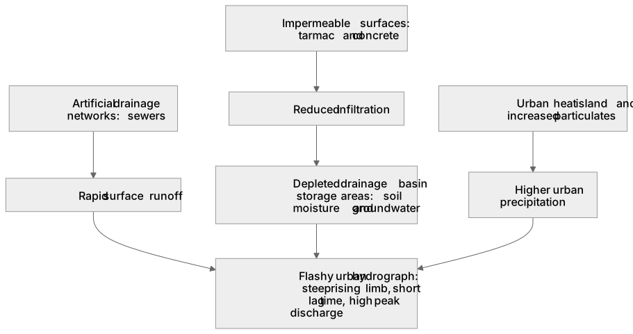
Urban areas significantly alter the local water cycle. Urban precipitation is often higher due to the urban heat island effect and increased particulate matter acting as condensation nuclei. Catchment characteristics change dramatically as natural vegetation is replaced by impermeable surfaces like tarmac and concrete, alongside artificial drainage networks (sewers). These surfaces severely reduce infiltration, leading to depleted drainage basin storage areas, such as soil moisture and groundwater aquifers. Consequently, the urban water cycle is dominated by rapid surface runoff rather than slow subsurface flows. When measured by hydrographs, water movement through urban catchments exhibits a 'flashy' response: a steep rising limb, a significantly shortened lag time, and a much higher peak discharge compared to rural catchments, increasing the local flood risk.
What earns the marks
- Explain how the urban heat island effect and increased atmospheric particulates lead to higher localized urban precipitation.
- Describe how impermeable surfaces (tarmac, concrete) and artificial drainage networks reduce infiltration and increase surface runoff.
- Analyse the reduction in drainage basin storage areas, specifically noting lower soil moisture and depleted groundwater stores.
- Interpret urban hydrographs, identifying characteristics such as a steep rising limb, high peak discharge, and short lag time.
Common mistakes and how to put them right
Stating that urban areas only affect the ground surface.
Put it right: Acknowledge that urban areas also alter atmospheric processes, often increasing local precipitation through the urban heat island effect.
Confusing lag time with the duration of the rainfall event.
Put it right: Define lag time specifically as the time difference between peak rainfall and peak discharge on a hydrograph.
Assuming groundwater storage increases due to leaking pipes.
Put it right: While leaks occur, the dominant overall impact of urbanisation is a significant reduction in groundwater storage due to impermeable surfaces preventing infiltration.
Exam tips
- When comparing urban and rural hydrographs, explicitly use terms like 'flashy', 'steep rising limb', and 'short lag time' to secure marks for hydrograph analysis.
- Link the physical characteristics of the catchment (e.g., high drainage density from sewers) directly to the speed of water movement shown on the hydrograph.
- Remember to discuss changes to storage areas (like soil moisture) as well as flows (like surface runoff) when evaluating the urban water cycle.
Try the lesson
The start of the Urban drainage: Urban precipitation, surfaces and catchment characteristics; impacts on drainage basin storage areas; urban water cycle: water movement through urban catchments as measured by hydrographs. lesson, made from checked teaching notes for this specification point.
Have a go first
How do impermeable urban surfaces typically alter the shape of a storm hydrograph compared to a rural catchment?
Listen
Urban areas significantly alter the local water cycle. Urban precipitation is often higher due to the urban heat island effect and increased particulate matter acting as condensation nuclei. Catchment characteristics change dramatically as natural vegetation is replaced by impermeable surfaces like tarmac and concrete, alongside artificial drainage networks (sewers). These surfaces severely reduce infiltration, leading to depleted drainage basin storage areas, such as soil moisture and groundwater aquifers. Consequently, the urban water cycle is dominated by rapid surface runoff rather than slow subsurface flows. When measured by hydrographs, water movement through urban catchments exhibits a 'flashy' response: a steep rising limb, a significantly shortened lag time, and a much higher peak discharge compared to rural catchments, increasing the local flood risk. A strong answer earns marks for these points. Explain how the urban heat island effect and increased atmospheric particulates lead to higher localized urban precipitation. Describe how impermeable surfaces (tarmac, concrete) and artificial drainage networks reduce infiltration and increase surface runoff. Analyse the reduction in drainage basin storage areas, specifically noting lower soil moisture and depleted groundwater stores. Interpret urban hydrographs, identifying characteristics such as a steep rising limb, high peak discharge, and short lag time. A common slip: Stating that urban areas only affect the ground surface. Instead, Acknowledge that urban areas also alter atmospheric processes, often increasing local precipitation through the urban heat island effect. Exam tip: When comparing urban and rural hydrographs, explicitly use terms like 'flashy', 'steep rising limb', and 'short lag time' to secure marks for hydrograph analysis.
See it
Key words
Say what each word means before you turn the card.
Urban water cycle
Try answering aloud or in your head before turning the card.
Drainage basin storage areas
Try answering aloud or in your head before turning the card.
Impermeable surfaces
Try answering aloud or in your head before turning the card.
Lag time
Try answering aloud or in your head before turning the card.
See every definition
- Urban water cycle
- Water movement through urban catchments as measured by hydrographs, dominated by rapid surface runoff rather than slow subsurface flows.
- Drainage basin storage areas
- Stores such as soil moisture and groundwater aquifers, which are depleted when impermeable surfaces severely reduce infiltration.
- Impermeable surfaces
- Surfaces like tarmac and concrete that replace natural vegetation and severely reduce infiltration, increasing surface runoff.
- Lag time
- The time difference between peak rainfall and peak discharge on a hydrograph, significantly shortened in urban catchments.
Label the diagram
Some boxes have lost their names. Pick the right name for each number.
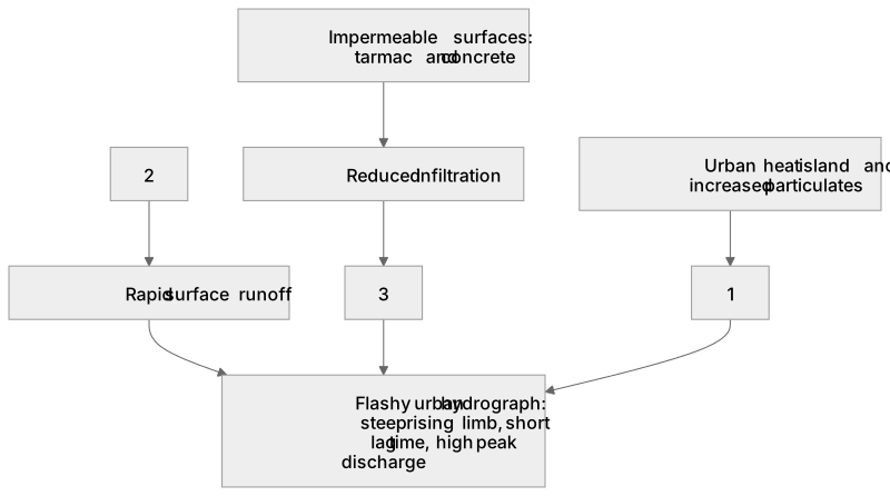
1Box 1
2Box 2
3Box 3
There is more to this lesson
The full lesson goes on to check your understanding and help you earn the marks. Create a free account to carry on, with your progress saved.
A week of Premium from your first lesson · Then the free plan continues · No card, no charge
Test your understanding of Urban drainage: Urban precipitation, surfaces and catchment characteristics; impacts on drainage basin storage areas; urban water cycle: water movement through urban catchments as measured by hydrographs.
Active recall beats re-reading. Take an instant quiz now to test what you’ve learned and lock it into long-term memory.
A week of Premium from your first lesson · Then the free plan continues · No card, no charge