AQA · A-Level · Geography
Course version: 7037 · Version from Sept 2018
Periglacial landforms: patterned ground, ice wedges, pingos, blockfields,…
Full specification wording
Glaciated landscape development: Periglacial landforms: patterned ground, ice wedges, pingos, blockfields, solifluction, lobes, terracettes, thermokarst. Characteristic periglacial landscapes.
Periglacial landscapes are shaped by intense frost action and permafrost dynamics.
Checked against the AQA 7037 specification (opens in a new tab) on .
- Point 4 of 4
Study notes
From the checked teaching notes for this specification point.
The idea
Periglacial landscapes are shaped by intense frost action and permafrost dynamics. Frost heave sorts sediments to form patterned ground, while thermal contraction creates cracks that fill with meltwater, freezing to form ice wedges. Groundwater freezing creates ice-cored mounds called pingos. Extensive freeze-thaw weathering shatters exposed rock, generating expansive blockfields. During summer, the active layer thaws and slides over impermeable permafrost via solifluction, creating solifluction lobes and step-like terracettes on slopes. When permafrost melts, ground subsidence forms water-filled depressions known as thermokarst. Together, these landforms create characteristic periglacial landscapes, such as the Mackenzie Delta, dominated by tundra, ground ice, and mass movement.
What earns the marks
- Explain frost heave and the sorting of sediments in the formation of patterned ground, such as stone polygons.
- Describe the role of thermal contraction and repeated seasonal freezing in the development of ice wedges.
- Differentiate between the formation of open-system pingos (e.g., East Greenland) and closed-system pingos (e.g., Mackenzie Delta).
- Explain solifluction as the slow downslope movement of the saturated active layer, resulting in lobes and terracettes.
- Link the melting of ground ice to ground subsidence and the formation of thermokarst landscapes.
Common mistakes and how to put them right
Confusing pingos with drumlins.
Put it right: Pingos are ice-cored mounds formed by groundwater freezing, whereas drumlins are subglacial depositional features.
Stating that solifluction occurs in winter.
Put it right: It actually occurs in summer when the active layer thaws and becomes saturated above the impermeable permafrost.
Assuming blockfields are deposited by glaciers.
Put it right: They are formed in situ by intense freeze-thaw weathering of exposed bedrock.
Exam tips
- Use specific examples of periglacial landscapes, such as the Mackenzie Delta, to illustrate the spatial distribution of pingos and thermokarst.
- When explaining patterned ground, clearly sequence the process of frost heave pushing larger stones to the surface and radially outwards.
- Link the formation of thermokarst directly to climate change and the degradation of permafrost in modern contexts.
Try the lesson
The start of the Glaciated landscape development: Periglacial landforms: patterned ground, ice wedges, pingos, blockfields, solifluction, lobes, terracettes, thermokarst. Characteristic periglacial landscapes. lesson, made from checked teaching notes for this specification point.
Have a go first
Which of the following best describes the formation of a closed-system pingo?
Listen
Periglacial landscapes are shaped by intense frost action and permafrost dynamics. Frost heave sorts sediments to form patterned ground, while thermal contraction creates cracks that fill with meltwater, freezing to form ice wedges. Groundwater freezing creates ice-cored mounds called pingos. Extensive freeze-thaw weathering shatters exposed rock, generating expansive blockfields. During summer, the active layer thaws and slides over impermeable permafrost via solifluction, creating solifluction lobes and step-like terracettes on slopes. When permafrost melts, ground subsidence forms water-filled depressions known as thermokarst. Together, these landforms create characteristic periglacial landscapes, such as the Mackenzie Delta, dominated by tundra, ground ice, and mass movement. A strong answer earns marks for these points. Explain frost heave and the sorting of sediments in the formation of patterned ground, such as stone polygons. Describe the role of thermal contraction and repeated seasonal freezing in the development of ice wedges. Differentiate between the formation of open-system pingos (e.g., East Greenland) and closed-system pingos (e.g., Mackenzie Delta). Explain solifluction as the slow downslope movement of the saturated active layer, resulting in lobes and terracettes. Exam tip: Use specific examples of periglacial landscapes, such as the Mackenzie Delta, to illustrate the spatial distribution of pingos and thermokarst.
See it
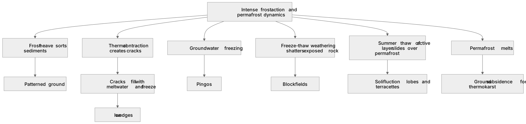
Label the diagram
Some boxes have lost their names. Pick the right name for each number.
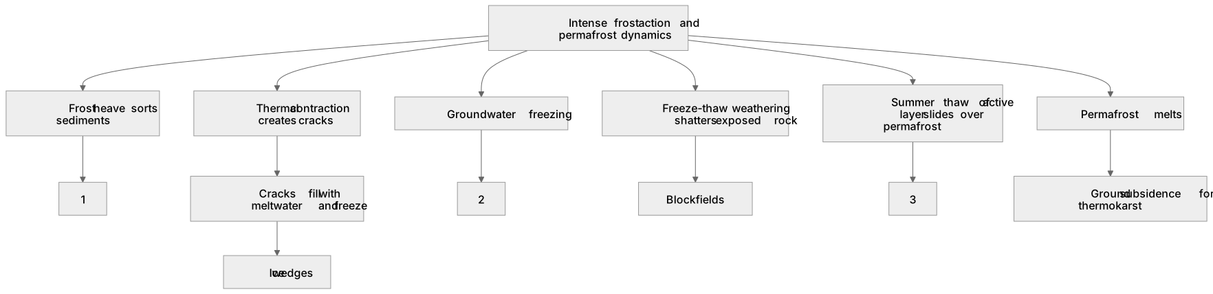
1Box 1
2Box 2
3Box 3
There is more to this lesson
The full lesson goes on to check your understanding and help you earn the marks. Create a free account to carry on, with your progress saved.
A week of Premium from your first lesson · Then the free plan continues · No card, no charge
Test your understanding of Glaciated landscape development: Periglacial landforms: patterned ground, ice wedges, pingos, blockfields, solifluction, lobes, terracettes, thermokarst. Characteristic periglacial landscapes.
Active recall beats re-reading. Take an instant quiz now to test what you’ve learned and lock it into long-term memory.
A week of Premium from your first lesson · Then the free plan continues · No card, no charge