AQA · A-Level · Geography
Course version: 7037 · Version from Sept 2018
Fluvioglacial landforms of erosion and deposition: meltwater channels,…
Full specification wording
Glaciated landscape development: Fluvioglacial landforms of erosion and deposition: meltwater channels, kames, eskers, outwash plains. Characteristic fluvioglacial landscapes.
Fluvioglacial landforms are created by glacial meltwater.
Checked against the AQA 7037 specification (opens in a new tab) on .
- Point 3 of 4
- 4 key terms
Study notes
From the checked teaching notes for this specification point.
The idea
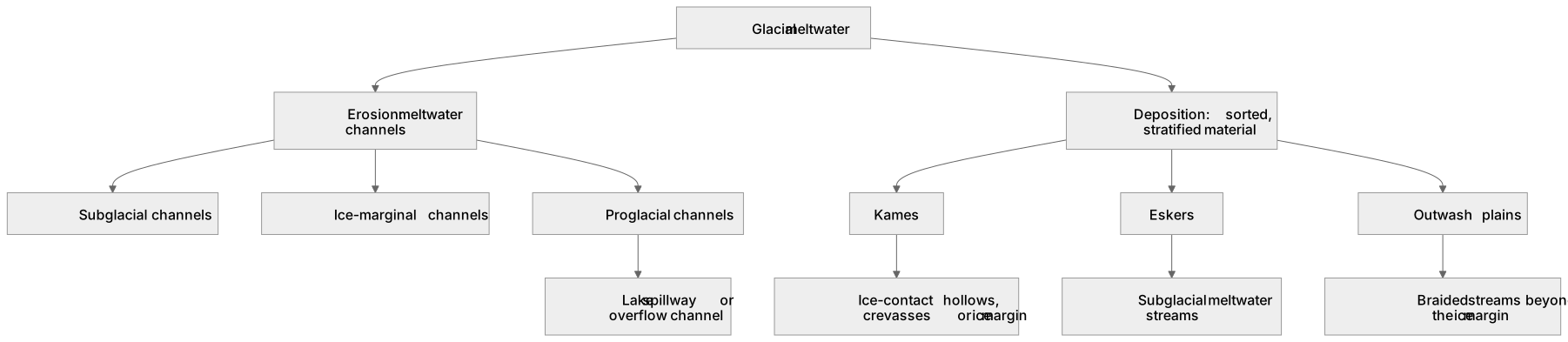
Fluvioglacial landforms are created by glacial meltwater. Meltwater channels can be subglacial, ice-marginal or proglacial; their form reflects water route, discharge, sediment load and pressure. Newtondale in North Yorkshire is a proglacial lake spillway or overflow channel, while some other channels were cut beneath ice under high hydrostatic pressure. Depositional landforms consist mainly of sorted, stratified material. Kames are mounds or terraces of sand and gravel deposited in ice-contact hollows, crevasses or at the ice margin. Eskers are long, sinuous ridges deposited by subglacial meltwater streams. Outwash plains (sandurs) are extensive areas deposited by braided streams beyond the ice margin. Together these features record changing meltwater routes during glacial retreat.
What earns the marks
- Explain how high meltwater discharge, sediment load and, for subglacial routes, hydrostatic pressure can erode meltwater channels, while recognising marginal and proglacial channels such as lake spillways.
- Describe the formation of kames as ice-contact depositional features formed in crevasses or proglacial lakes.
- Explain how eskers form from the deposition of sorted sand and gravel in subglacial meltwater tunnels.
- Detail the formation of outwash plains by braided streams depositing sediment beyond the terminal moraine.
- Identify the key characteristics of fluvioglacial deposits, noting they are sorted, stratified, and rounded compared to glacial till.
Common mistakes and how to put them right
Confusing eskers with moraines.
Put it right: Eskers are sinuous ridges of sorted fluvioglacial deposits, whereas moraines are ridges of unsorted glacial till.
Stating that every meltwater channel formed beneath the ice.
Put it right: Distinguish subglacial channels from ice-marginal and proglacial or overflow channels, including Newtondale as a proglacial lake spillway.
Describing outwash plain deposits as unsorted.
Put it right: Outwash deposits are sorted by meltwater, with larger materials dropped first and finer sediments carried further away.
Exam tips
- Always emphasise the sorted and stratified nature of fluvioglacial deposits when distinguishing them from direct glacial deposition.
- Use annotated diagrams to show the subglacial formation of eskers and how they are revealed after ice retreat.
- Reference specific characteristic landscapes, such as the outwash plains of Iceland (sandurs), to demonstrate real-world application.
Try the lesson
The start of the Glaciated landscape development: Fluvioglacial landforms of erosion and deposition: meltwater channels, kames, eskers, outwash plains. Characteristic fluvioglacial landscapes. lesson, made from checked teaching notes for this specification point.
Have a go first
Which of the following landforms is created by fluvioglacial deposition within a subglacial meltwater channel?
Listen
Fluvioglacial landforms are created by glacial meltwater. Meltwater channels can be subglacial, ice-marginal or proglacial; their form reflects water route, discharge, sediment load and pressure. Newtondale in North Yorkshire is a proglacial lake spillway or overflow channel, while some other channels were cut beneath ice under high hydrostatic pressure. Depositional landforms consist mainly of sorted, stratified material. Kames are mounds or terraces of sand and gravel deposited in ice-contact hollows, crevasses or at the ice margin. Eskers are long, sinuous ridges deposited by subglacial meltwater streams. Outwash plains (sandurs) are extensive areas deposited by braided streams beyond the ice margin. Together these features record changing meltwater routes during glacial retreat. A strong answer earns marks for these points. Explain how high meltwater discharge, sediment load and, for subglacial routes, hydrostatic pressure can erode meltwater channels, while recognising marginal and proglacial channels such as lake spillways. Describe the formation of kames as ice-contact depositional features formed in crevasses or proglacial lakes. Explain how eskers form from the deposition of sorted sand and gravel in subglacial meltwater tunnels. Detail the formation of outwash plains by braided streams depositing sediment beyond the terminal moraine. Exam tip: Always emphasise the sorted and stratified nature of fluvioglacial deposits when distinguishing them from direct glacial deposition.
See it
Key words
Say what each word means before you turn the card.
Fluvioglacial processes
Try answering aloud or in your head before turning the card.
Meltwater channels
Try answering aloud or in your head before turning the card.
Kames
Try answering aloud or in your head before turning the card.
Eskers
Try answering aloud or in your head before turning the card.
See every definition
- Fluvioglacial processes
- Processes creating landforms of erosion and deposition through glacial meltwater, including meltwater channels, kames, eskers and outwash plains.
- Meltwater channels
- Channels that can be subglacial, ice-marginal or proglacial, with their form reflecting water route, discharge, sediment load and pressure.
- Kames
- Mounds or terraces of sand and gravel deposited in ice-contact hollows, crevasses or at the ice margin.
- Eskers
- Long, sinuous ridges deposited by subglacial meltwater streams.
Label the diagram
Some boxes have lost their names. Pick the right name for each number.
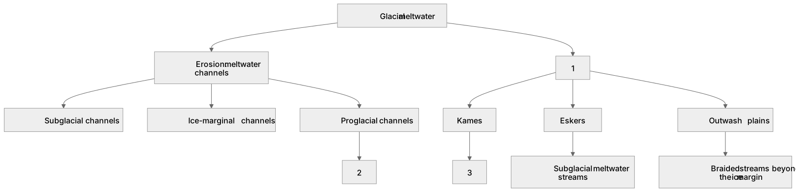
1Box 1
2Box 2
3Box 3
There is more to this lesson
The full lesson goes on to check your understanding and help you earn the marks. Create a free account to carry on, with your progress saved.
A week of Premium from your first lesson · Then the free plan continues · No card, no charge
Test your understanding of Glaciated landscape development: Fluvioglacial landforms of erosion and deposition: meltwater channels, kames, eskers, outwash plains. Characteristic fluvioglacial landscapes.
Active recall beats re-reading. Take an instant quiz now to test what you’ve learned and lock it into long-term memory.
A week of Premium from your first lesson · Then the free plan continues · No card, no charge