AQA · A-Level · Geography
Course version: 7037 · Version from Sept 2018
Use of ICT to generate evidence of many of the skills provided above such…
Full specification wording
ICT skills: Use of ICT to generate evidence of many of the skills provided above such as producing maps, graphs and statistical calculations.
Information and Communication Technology (ICT) is essential for processing and presenting geographical data accurately.
Checked against the AQA 7037 specification (opens in a new tab) on .
- Point 4 of 4
- 2 key terms
Study notes
From the checked teaching notes for this specification point.
The idea
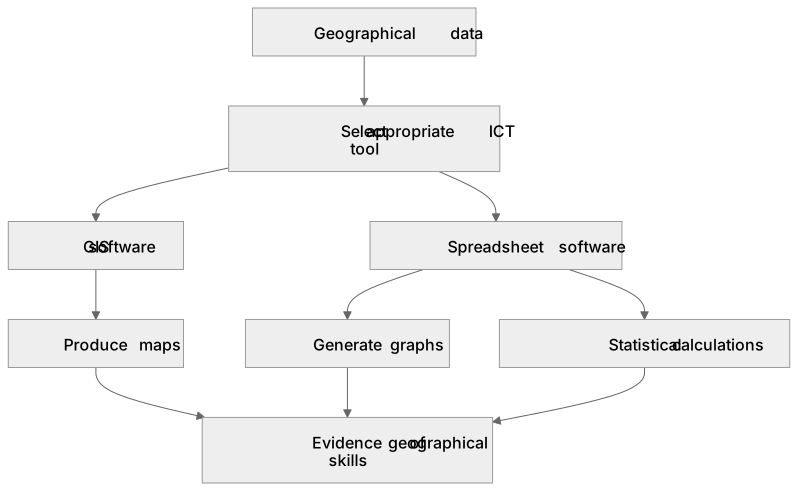
Information and Communication Technology (ICT) is essential for processing and presenting geographical data accurately. Geographic Information Systems (GIS) are used to produce layered maps, such as choropleth maps, linking spatial data to locations. Spreadsheet software is invaluable for creating complex graphs like scatter plots, allowing for rapid visual analysis. Furthermore, these programs facilitate complex statistical calculations, such as computing Spearman's rank correlation coefficient or standard deviation, reducing human error and handling large datasets that would be impractical to process manually.
What earns the marks
- Demonstrate the ability to select appropriate ICT tools, such as GIS or spreadsheets, for specific geographical data processing tasks.
- Produce accurate and appropriately scaled maps using GIS software, ensuring all standard map conventions are applied.
- Generate clear, accurately labelled graphs using spreadsheet software to represent complex geographical datasets.
- Execute statistical calculations using software functions to analyse data relationships, such as correlation or dispersion.
Common mistakes and how to put them right
Relying entirely on software defaults for graph axes and titles, resulting in missing units or unclear labels.
Put it right: Manually format ICT-generated graphs to include specific, descriptive titles and axis labels with correct units.
Using inappropriate map types in GIS, such as creating a choropleth map for discrete, absolute data.
Put it right: Select map types based on data characteristics, using proportional symbols for absolute values and choropleths for densities or percentages.
Accepting the output of a statistical calculation without checking if the data meets the requirements for that specific test.
Put it right: Verify that the dataset meets the assumptions of the statistical test before using software to calculate the result.
Exam tips
- When evaluating data presentation methods, explicitly mention the advantages of using ICT, such as the ability to easily update data or overlay multiple variables.
- Be prepared to interpret maps and graphs that have clearly been generated using GIS or spreadsheet software, paying close attention to computer-generated legends.
- Remember that while ICT reduces calculation errors in statistics, you must still be able to interpret the geographical significance of the generated p-value or correlation coefficient.
Try the lesson
The start of the ICT skills: Use of ICT to generate evidence of many of the skills provided above such as producing maps, graphs and statistical calculations. lesson, made from checked teaching notes for this specification point.
Have a go first
A student is using ICT to generate evidence for a geographical investigation. Which software type is most appropriate for analysing the spatial relationship between multiple georeferenced datasets to produce a choropleth map?
Listen
Information and Communication Technology (ICT) is essential for processing and presenting geographical data accurately. Geographic Information Systems (GIS) are used to produce layered maps, such as choropleth maps, linking spatial data to locations. Spreadsheet software is invaluable for creating complex graphs like scatter plots, allowing for rapid visual analysis. Furthermore, these programs facilitate complex statistical calculations, such as computing Spearman's rank correlation coefficient or standard deviation, reducing human error and handling large datasets that would be impractical to process manually. A strong answer earns marks for these points. Demonstrate the ability to select appropriate ICT tools, such as GIS or spreadsheets, for specific geographical data processing tasks. Produce accurate and appropriately scaled maps using GIS software, ensuring all standard map conventions are applied. Generate clear, accurately labelled graphs using spreadsheet software to represent complex geographical datasets. Execute statistical calculations using software functions to analyse data relationships, such as correlation or dispersion. Exam tip: When evaluating data presentation methods, explicitly mention the advantages of using ICT, such as the ability to easily update data or overlay multiple variables.
See it
Key words
Say what each word means before you turn the card.
Geographic Information Systems (GIS)
Try answering aloud or in your head before turning the card.
Statistical analysis
Try answering aloud or in your head before turning the card.
See every definition
- Geographic Information Systems (GIS)
- Software used to produce layered maps, such as choropleth maps, linking spatial data to locations.
- Statistical analysis
- Using software functions to perform complex statistical calculations, such as computing Spearman's rank correlation coefficient or standard deviation, reducing human error and handling large datasets.
Label the diagram
Some boxes have lost their names. Pick the right name for each number.
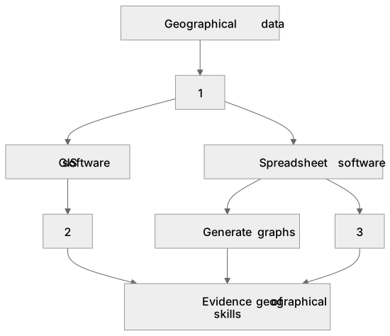
1Box 1
2Box 2
3Box 3
There is more to this lesson
The full lesson goes on to check your understanding and help you earn the marks. Create a free account to carry on, with your progress saved.
A week of Premium from your first lesson · Then the free plan continues · No card, no charge
Test your understanding of ICT skills: Use of ICT to generate evidence of many of the skills provided above such as producing maps, graphs and statistical calculations.
Active recall beats re-reading. Take an instant quiz now to test what you’ve learned and lock it into long-term memory.
A week of Premium from your first lesson · Then the free plan continues · No card, no charge