AQA · A-Level · Geography
Course version: 7037 · Version from Sept 2018
Relationship of energy supply (volume and quality) to key aspects of…
Full specification wording
Energy security: Relationship of energy supply (volume and quality) to key aspects of physical geography – climate, geology and drainage.
Physical geography dictates the volume and quality of a region's domestic energy supply.
Checked against the AQA 7037 specification (opens in a new tab) on .
- Point 2 of 7
Study notes
From the checked teaching notes for this specification point.
The idea
Physical geography dictates the volume and quality of a region's domestic energy supply. Geology determines the presence of high-quality, energy-dense fossil fuels; sedimentary basins trap oil and gas, while tectonic boundaries offer geothermal potential. Climate controls the viability of renewable supplies; high insolation levels in arid regions provide reliable solar volume, whereas consistent prevailing winds are essential for wind power. Drainage patterns directly influence hydroelectric power (HEP) capacity. A steep river gradient combined with high, reliable discharge in a large drainage basin ensures a high-volume, continuous energy supply. Understanding these physical constraints explains why energy security varies globally, as nations are bound by their natural endowments.
What earns the marks
- Explain how geological structures, such as sedimentary basins, control the volume and accessibility of fossil fuel reserves.
- Assess how climatic factors, including insolation and wind speed, determine the reliability and volume of renewable energy supplies.
- Link drainage basin characteristics, such as river discharge and gradient, to the potential volume of hydroelectric power generation.
- Evaluate the concept of energy 'quality' in relation to physical geography, such as the high energy density of geologically formed anthracite coal versus lower-quality lignite.
Common mistakes and how to put them right
Ignoring the 'quality' aspect of the specification.
Put it right: Explicitly discuss energy density or reliability alongside total volume.
Failing to link drainage to specific physical parameters.
Put it right: Refer to river discharge, velocity, and valley cross-profiles rather than just stating that water is needed for HEP.
Overlooking the role of geology in renewables.
Put it right: Geology also dictates geothermal energy potential and the availability of uranium for nuclear power.
Exam tips
- Structure essays on this topic by dedicating distinct paragraphs to climate, geology, and drainage to ensure full coverage of the specification.
- Use specific geographical examples, such as the geology of the Middle East for oil or the drainage of the Amazon basin for HEP, to illustrate physical relationships.
- Explicitly use the terms 'volume' and 'quality' when evaluating how physical geography impacts a nation's energy supply.
Try the lesson
The start of the Energy security: Relationship of energy supply (volume and quality) to key aspects of physical geography – climate, geology and drainage. lesson, made from checked teaching notes for this specification point.
Have a go first
Which aspect of physical geography is the primary determinant for the location and volume of fossil fuel reserves such as coal and oil?
Listen
Physical geography dictates the volume and quality of a region's domestic energy supply. Geology determines the presence of high-quality, energy-dense fossil fuels; sedimentary basins trap oil and gas, while tectonic boundaries offer geothermal potential. Climate controls the viability of renewable supplies; high insolation levels in arid regions provide reliable solar volume, whereas consistent prevailing winds are essential for wind power. Drainage patterns directly influence hydroelectric power (HEP) capacity. A steep river gradient combined with high, reliable discharge in a large drainage basin ensures a high-volume, continuous energy supply. Understanding these physical constraints explains why energy security varies globally, as nations are bound by their natural endowments. A strong answer earns marks for these points. Explain how geological structures, such as sedimentary basins, control the volume and accessibility of fossil fuel reserves. Assess how climatic factors, including insolation and wind speed, determine the reliability and volume of renewable energy supplies. Link drainage basin characteristics, such as river discharge and gradient, to the potential volume of hydroelectric power generation. Evaluate the concept of energy 'quality' in relation to physical geography, such as the high energy density of geologically formed anthracite coal versus lower-quality lignite. A common slip: Ignoring the 'quality' aspect of the specification. Instead, explicitly discuss energy density or reliability alongside total volume. Exam tip: Structure essays on this topic by dedicating distinct paragraphs to climate, geology, and drainage to ensure full coverage of the specification.
See it

Label the diagram
Some boxes have lost their names. Pick the right name for each number.
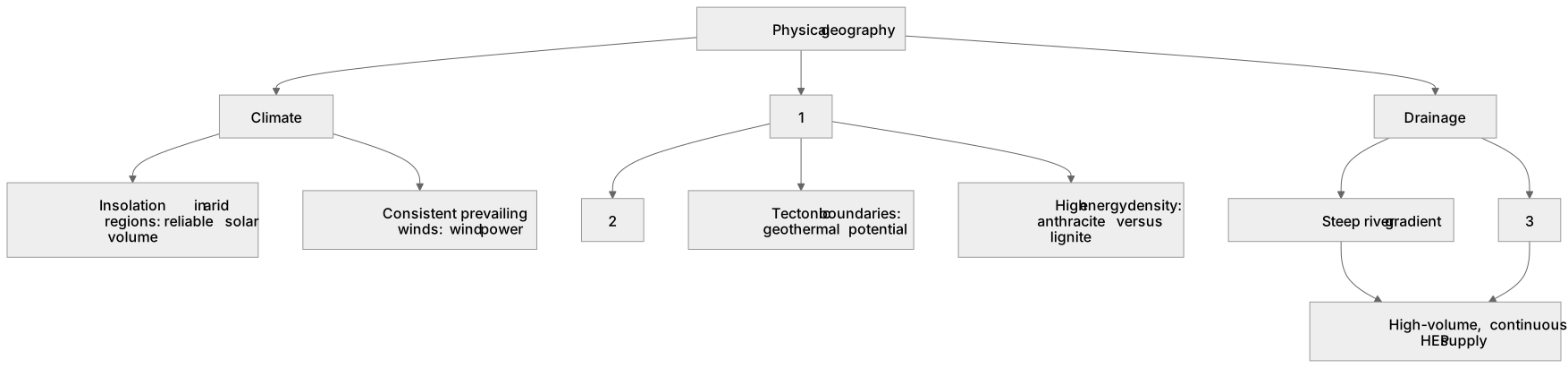
1Box 1
2Box 2
3Box 3
There is more to this lesson
The full lesson goes on to check your understanding and help you earn the marks. Create a free account to carry on, with your progress saved.
A week of Premium from your first lesson · Then the free plan continues · No card, no charge
Test your understanding of Energy security: Relationship of energy supply (volume and quality) to key aspects of physical geography – climate, geology and drainage.
Active recall beats re-reading. Take an instant quiz now to test what you’ve learned and lock it into long-term memory.
A week of Premium from your first lesson · Then the free plan continues · No card, no charge