AQA · A-Level · Geography
Course version: 7037 · Version from Sept 2018
Origin and development of landforms and landscapes of glacial deposition:…
Full specification wording
Glaciated landscape development: Origin and development of landforms and landscapes of glacial deposition: drumlins, erratics, moraines, till plains. Characteristic glaciated landscapes.
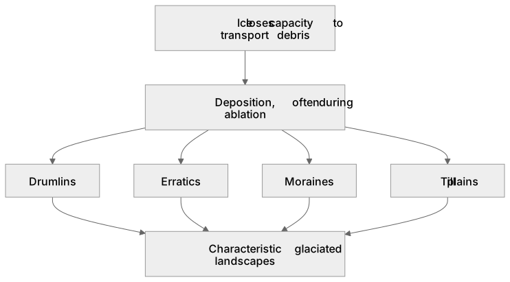
Glacial deposition occurs when ice loses capacity to transport debris, often during ablation.
Checked against the AQA 7037 specification (opens in a new tab) on .
- Point 2 of 4
- 4 key terms
Study notes
From the checked teaching notes for this specification point.
The idea
Glacial deposition occurs when ice loses capacity to transport debris, often during ablation. Drumlins are streamlined mounds of till formed by subglacial deformation or deposition around an obstacle, indicating ice flow direction. Erratics are boulders transported by ice and deposited on differing geology, like the Silurian grit erratics on carboniferous limestone in the Yorkshire Dales. Moraines (terminal, lateral, medial, recessional) are ridges of unsorted till marking ice margins or debris pathways. Till plains form when a large ice sheet retreats, depositing a vast, flat layer of basal till. Together, these landforms create characteristic glaciated landscapes, such as the Ribble Valley, reflecting the complex interplay of ice movement, sediment supply, and climate change over time.
What earns the marks
- Explain the formation of drumlins using theories of subglacial deformation or obstacle deposition.
- Describe how erratics provide evidence of past ice movement directions and source regions.
- Differentiate between types of moraine (lateral, medial, terminal, recessional) based on their position and formation mechanisms.
- Explain the formation of till plains through the widespread deposition of basal till during ice sheet retreat.
- Synthesise how individual depositional landforms combine to form characteristic glaciated landscapes.
Common mistakes and how to put them right
Confusing the steep (stoss) and gentle (lee) sides of a drumlin.
Put it right: The stoss side faces up-glacier, while the lee side points in the direction of ice flow.
Describing glacial till as sorted and stratified.
Put it right: Till is characteristically unsorted and unstratified because ice drops all sediment sizes simultaneously upon melting.
Assuming erratics are formed by fluvial processes.
Put it right: Erratics are transported exclusively by glacial ice and deposited on contrasting bedrock.
Exam tips
- Use specific examples of characteristic landscapes, such as the drumlin swarms in the Ribble Valley or erratics in the Yorkshire Dales, to support your explanations.
- When discussing moraines, clearly link the type of moraine to the specific glacial process, such as terminal moraines marking the maximum extent of ice advance.
- Draw annotated diagrams to illustrate the formation of drumlins and the different types of moraines, ensuring you label the ice flow direction.
Try the lesson
The start of the Glaciated landscape development: Origin and development of landforms and landscapes of glacial deposition: drumlins, erratics, moraines, till plains. Characteristic glaciated landscapes. lesson, made from checked teaching notes for this specification point.
Have a go first
Which of the following best describes the origin of a glacial erratic?
Listen
Glacial deposition occurs when ice loses capacity to transport debris, often during ablation. Drumlins are streamlined mounds of till formed by subglacial deformation or deposition around an obstacle, indicating ice flow direction. Erratics are boulders transported by ice and deposited on differing geology, like the Silurian grit erratics on carboniferous limestone in the Yorkshire Dales. Moraines (terminal, lateral, medial, recessional) are ridges of unsorted till marking ice margins or debris pathways. Till plains form when a large ice sheet retreats, depositing a vast, flat layer of basal till. Together, these landforms create characteristic glaciated landscapes, such as the Ribble Valley, reflecting the complex interplay of ice movement, sediment supply, and climate change over time. A strong answer earns marks for these points. Explain the formation of drumlins using theories of subglacial deformation or obstacle deposition. Describe how erratics provide evidence of past ice movement directions and source regions. Differentiate between types of moraine (lateral, medial, terminal, recessional) based on their position and formation mechanisms. Explain the formation of till plains through the widespread deposition of basal till during ice sheet retreat. Exam tip: Use specific examples of characteristic landscapes, such as the drumlin swarms in the Ribble Valley or erratics in the Yorkshire Dales, to support your explanations.
See it
Key words
Say what each word means before you turn the card.
Glacial deposition
Try answering aloud or in your head before turning the card.
Drumlins
Try answering aloud or in your head before turning the card.
Erratics
Try answering aloud or in your head before turning the card.
Till plains
Try answering aloud or in your head before turning the card.
See every definition
- Glacial deposition
- Occurs when ice loses capacity to transport debris, often during ablation.
- Drumlins
- Streamlined mounds of till formed by subglacial deformation or deposition around an obstacle, indicating ice flow direction.
- Erratics
- Boulders transported by ice and deposited on differing geology, like the Silurian grit erratics on carboniferous limestone in the Yorkshire Dales.
- Till plains
- Form when a large ice sheet retreats, depositing a vast, flat layer of basal till.
Label the diagram
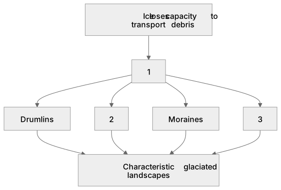
Some boxes have lost their names. Pick the right name for each number.
1Box 1
2Box 2
3Box 3
There is more to this lesson
The full lesson goes on to check your understanding and help you earn the marks. Create a free account to carry on, with your progress saved.
A week of Premium from your first lesson · Then the free plan continues · No card, no charge
Test your understanding of Glaciated landscape development: Origin and development of landforms and landscapes of glacial deposition: drumlins, erratics, moraines, till plains. Characteristic glaciated landscapes.
Active recall beats re-reading. Take an instant quiz now to test what you’ve learned and lock it into long-term memory.
A week of Premium from your first lesson · Then the free plan continues · No card, no charge