AQA · A-Level · Geography
Course version: 7037 · Version from Sept 2018
An ability to collect and use digital and geo-located data, and understand…
Full specification wording
Qualitative skills and quantitative skills: an ability to collect and use digital and geo-located data, and understand a range of approaches to use and analyse such data
Digital and geo-located data are fundamental to modern geographical enquiry.
Checked against the AQA 7037 specification (opens in a new tab) on .
- Point 5 of 6
- 2 key terms
Study notes
From the checked teaching notes for this specification point.
The idea
Digital and geo-located data are fundamental to modern geographical enquiry. Collecting this data involves using GPS devices, smartphone applications (like Survey123), or downloading secondary datasets (such as census data or satellite imagery) that possess spatial coordinates. Using this data requires Geographic Information Systems (GIS) like ArcGIS or QGIS to map and visualise spatial patterns. To analyse geo-located data, geographers employ approaches such as overlay analysis to identify relationships between variables (e.g., flood risk zones and population density), proximity analysis (buffering), and spatial interpolation. Understanding these approaches allows you to transform raw digital coordinates into meaningful geographical conclusions, evaluating spatial distributions and trends effectively.
What earns the marks
- Identify appropriate methods for collecting primary geo-located data, such as using GPS receivers or mobile mapping applications during fieldwork.
- Explain how secondary digital datasets, including satellite imagery and government databases, can be integrated into geographical investigations.
- Describe analytical approaches within GIS, such as buffering, overlay analysis, and heat mapping, to interpret spatial relationships.
- Evaluate the limitations of digital data collection, including GPS accuracy errors, signal loss, and the reliability of secondary digital sources.
Common mistakes and how to put them right
Confusing digital data collection with simple internet research.
Put it right: Specify that geo-located digital data must include spatial coordinates (latitude and longitude) for mapping.
Stating that GIS only creates maps.
Put it right: Explain that GIS is an analytical tool used to interrogate data, such as performing overlay analysis to find spatial correlations.
Ignoring the scale and resolution of digital data.
Put it right: Consider how the spatial resolution of a dataset (e.g., pixel size in satellite imagery) affects the accuracy of the analysis.
Exam tips
- When proposing a fieldwork methodology, explicitly name the digital tools or apps you would use to collect geo-located data.
- Use specific GIS terminology, such as 'data layers', 'polygons', and 'spatial analysis', when describing how you would process digital data.
- Always link the choice of digital data analysis approach back to the original geographical aim or hypothesis of the investigation.
Try the lesson
The start of the Qualitative skills and quantitative skills: an ability to collect and use digital and geo-located data, and understand a range of approaches to use and analyse such data lesson, made from checked teaching notes for this specification point.
Have a go first
Which of the following describes the primary function of a Global Positioning System (GPS) device when collecting primary field data?
Listen
Digital and geo-located data are fundamental to modern geographical enquiry. Collecting this data involves using GPS devices, smartphone applications (like Survey123), or downloading secondary datasets (such as census data or satellite imagery) that possess spatial coordinates. Using this data requires Geographic Information Systems (GIS) like ArcGIS or QGIS to map and visualise spatial patterns. To analyse geo-located data, geographers employ approaches such as overlay analysis to identify relationships between variables (e.g., flood risk zones and population density), proximity analysis (buffering), and spatial interpolation. Understanding these approaches allows you to transform raw digital coordinates into meaningful geographical conclusions, evaluating spatial distributions and trends effectively. A strong answer earns marks for these points. Identify appropriate methods for collecting primary geo-located data, such as using GPS receivers or mobile mapping applications during fieldwork. Explain how secondary digital datasets, including satellite imagery and government databases, can be integrated into geographical investigations. Describe analytical approaches within GIS, such as buffering, overlay analysis, and heat mapping, to interpret spatial relationships. Evaluate the limitations of digital data collection, including GPS accuracy errors, signal loss, and the reliability of secondary digital sources. A common slip: Confusing digital data collection with simple internet research. Instead, specify that geo-located digital data must include spatial coordinates (latitude and longitude) for mapping. Exam tip: When proposing a fieldwork methodology, explicitly name the digital tools or apps you would use to collect geo-located data.
See it
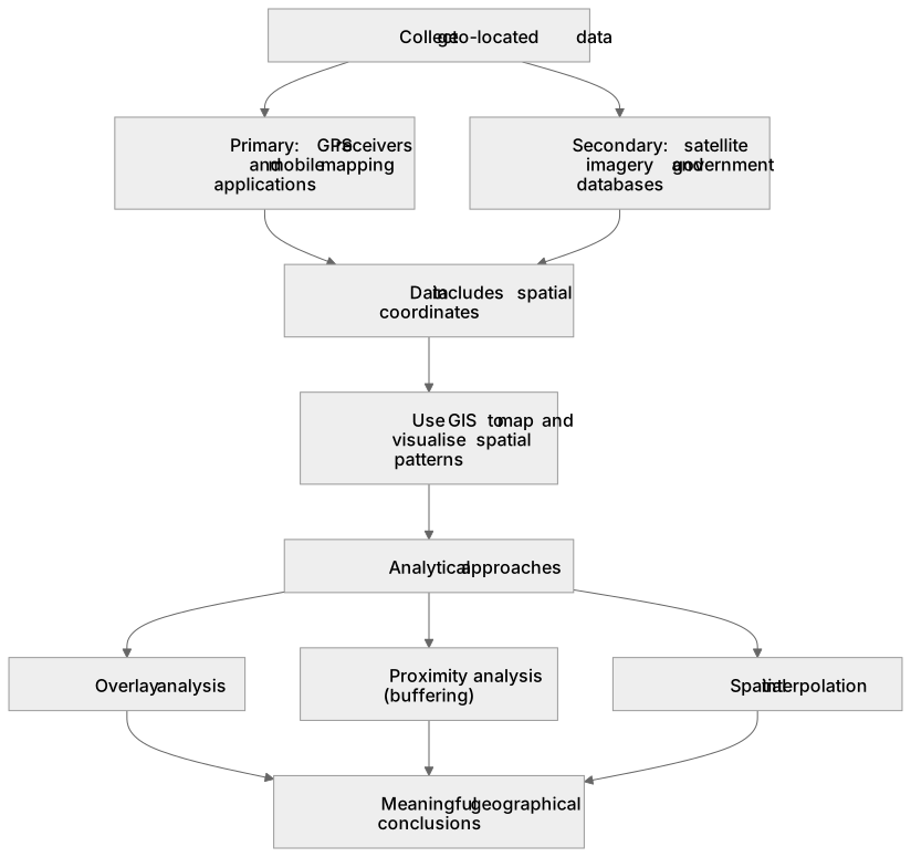
Key words
Say what each word means before you turn the card.
Geographic Information Systems (GIS)
Try answering aloud or in your head before turning the card.
Spatial Analysis
Try answering aloud or in your head before turning the card.
See every definition
- Geographic Information Systems (GIS)
- Systems used to map and visualise spatial patterns in geo-located data.
- Spatial Analysis
- Analytical approaches such as overlay analysis, proximity analysis (buffering) and spatial interpolation used to interpret spatial relationships.
Label the diagram
Some boxes have lost their names. Pick the right name for each number.
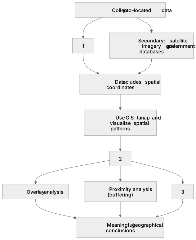
1Box 1
2Box 2
3Box 3
There is more to this lesson
The full lesson goes on to check your understanding and help you earn the marks. Create a free account to carry on, with your progress saved.
A week of Premium from your first lesson · Then the free plan continues · No card, no charge
Test your understanding of Qualitative skills and quantitative skills: an ability to collect and use digital and geo-located data, and understand a range of approaches to use and analyse such data
Active recall beats re-reading. Take an instant quiz now to test what you’ve learned and lock it into long-term memory.
A week of Premium from your first lesson · Then the free plan continues · No card, no charge