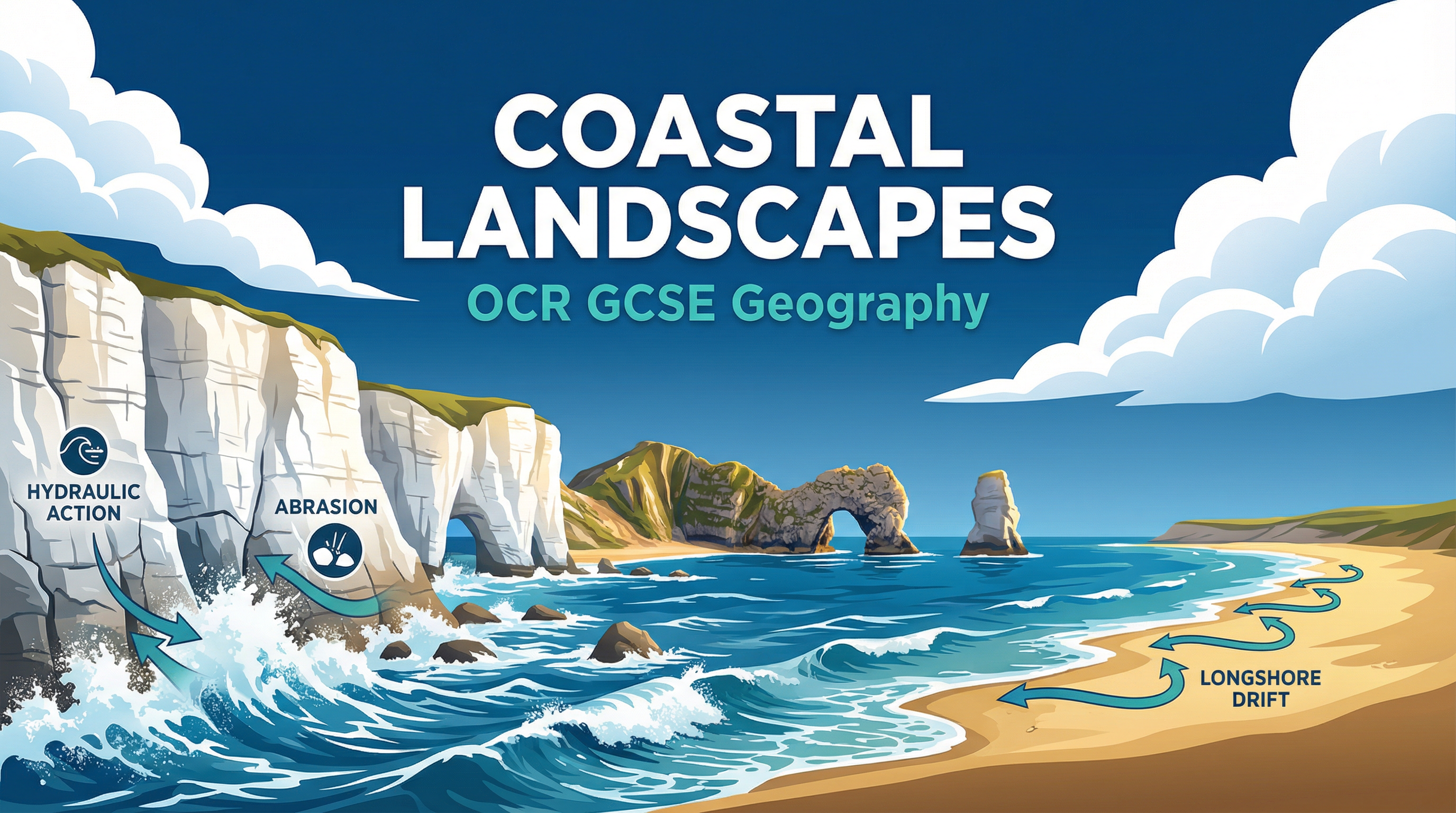
Coastal Landscapes Revision Notes
Subject: Geography | Level: GCSE | Exam Board: OCR
This study guide provides a comprehensive, exam-focused breakdown of Coastal Landscapes for OCR GCSE Geography. It explores the dynamic processes that shape our coastlines, the distinctive landforms created, and the complex challenges of coastal management, equipping candidates with the precise knowledge and skills needed to achieve top marks.
Revision Notes & Key Concepts
## Overview
Coastal landscapes are one of the most dynamic and rapidly changing environments studied in GCSE Geography. This topic, a core component of the 'Landscapes of the UK' paper, requires candidates to adopt a systems-based approach, understanding the intricate relationships between wave energy, geological structure, and geomorphic processes. Examiners expect to see a clear grasp of how erosion, transport, and deposition work together to create a variety of distinctive landforms, from towering cliffs and wave-cut platforms to spits and bars. Furthermore, a detailed understanding of a specific UK coastal landscape case study is essential for accessing higher-level marks. This guide will focus on the Holderness Coast, providing the specific data and evaluative points required. Success in this topic hinges on moving beyond simple descriptions to provide sequenced, process-based explanations and nuanced evaluations of coastal management strategies.

## Key Concepts: Geomorphic Processes
### Wave Types
**Constructive Waves**: These are low-energy waves with a strong swash and weak backwash. They carry material up the beach and deposit it, building up the beach profile. They are characterised by a long wavelength and low frequency (6-8 per minute).
**Destructive Waves**: These are high-energy waves with a weak swash and a powerful backwash. They erode material from the beach and carry it offshore. They have a short wavelength and high frequency (12-14 per minute).
### Processes of Coastal Erosion
**Hydraulic Action**: The sheer force of the water crashing against the coastline. When waves strike a cliff, air is trapped and compressed in cracks and joints. As the wave retreats, the pressure is released explosively, weakening the rock over time.
**Abrasion (or Corrasion)**: This is the 'sandpaper' effect. It occurs when rocks and other sediment carried by the waves are thrown against the cliff face, scouring and grinding it away. This is often the most significant erosional process.
**Attrition**: This process does not directly erode the coast, but instead wears down the sediment itself. Rocks and pebbles being transported by the sea repeatedly knock into each other, becoming smaller, smoother, and more rounded.
**Solution (or Corrosion)**: The chemical erosion of the coastline. Seawater is slightly acidic, and it can dissolve certain types of rock, most notably limestone and chalk.
### Coastal Transportation
**Longshore Drift (LSD)**: This is the primary process for moving sediment along the coastline. Waves, driven by the prevailing wind, approach the beach at an angle. The swash carries sediment up the beach at this angle. The backwash then pulls the material straight back down the beach at a right angle due to gravity. This continuous zigzag movement transports vast quantities of sand and shingle along the coast.
## Landform Formation
### Erosional Landforms
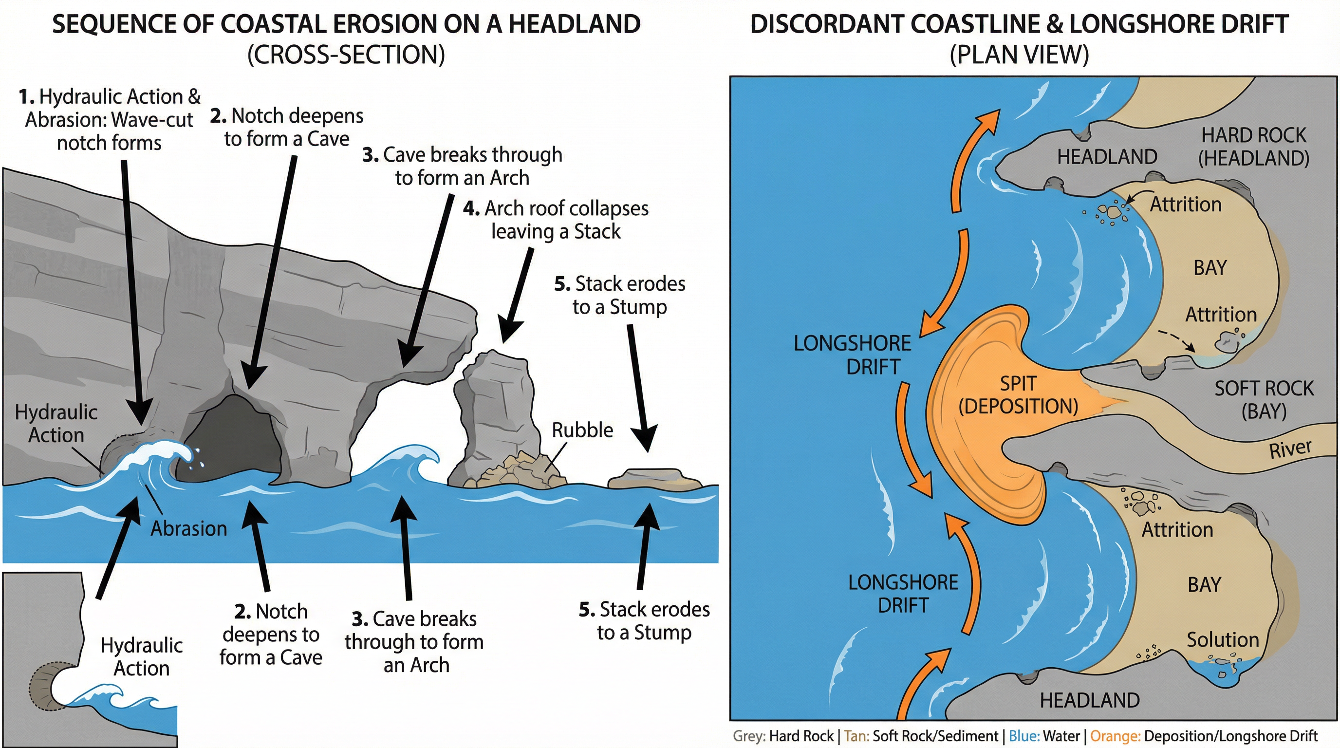
**Headlands and Bays**: These form on discordant coastlines, where bands of hard and soft rock are perpendicular to the coast. The less resistant soft rock (e.g., clay) is eroded more quickly to form bays, while the more resistant hard rock (e.g., chalk) is left jutting out into the sea as headlands.
**Cliffs and Wave-Cut Platforms**: Destructive waves attack the base of a cliff through hydraulic action and abrasion, forming a wave-cut notch. As the notch deepens, the overlying rock becomes unstable and collapses. This process repeats, causing the cliff to retreat and leaving behind a gently sloping rocky surface called a wave-cut platform, which is visible at low tide.
**Caves, Arches, Stacks, and Stumps**: This is a classic sequence of erosion occurring on a headland.
1. **Cave**: Weaknesses in the headland are exploited by erosion, widening to form a cave.
2. **Arch**: If the cave erodes through to the other side of the headland, an arch is formed.
3. **Stack**: The roof of the arch is weakened by weathering and eventually collapses, leaving a detached pillar of rock known as a stack (e.g., Old Harry in Dorset).
4. **Stump**: The stack is eroded at its base by the sea and eventually collapses to form a stump, which is often only visible at low tide.
### Depositional Landforms
**Beaches**: The accumulation of sand and shingle deposited by constructive waves between the high and low water marks.
**Spits**: A long, narrow finger of sand or shingle that extends from the land out into the sea or across an estuary. Spits form where the coastline changes direction and longshore drift continues to deposit material in the same direction. The end of the spit is often curved by secondary winds and waves, forming a recurved end. A salt marsh often develops in the sheltered, low-energy zone behind the spit. Spurn Head on the Holderness Coast is a classic example.
**Bars**: A bar is a ridge of sand or shingle that has grown across the mouth of a bay, cutting off the sea and forming a lagoon behind it. This can happen if a spit continues to grow across a bay.
## Coastal Management
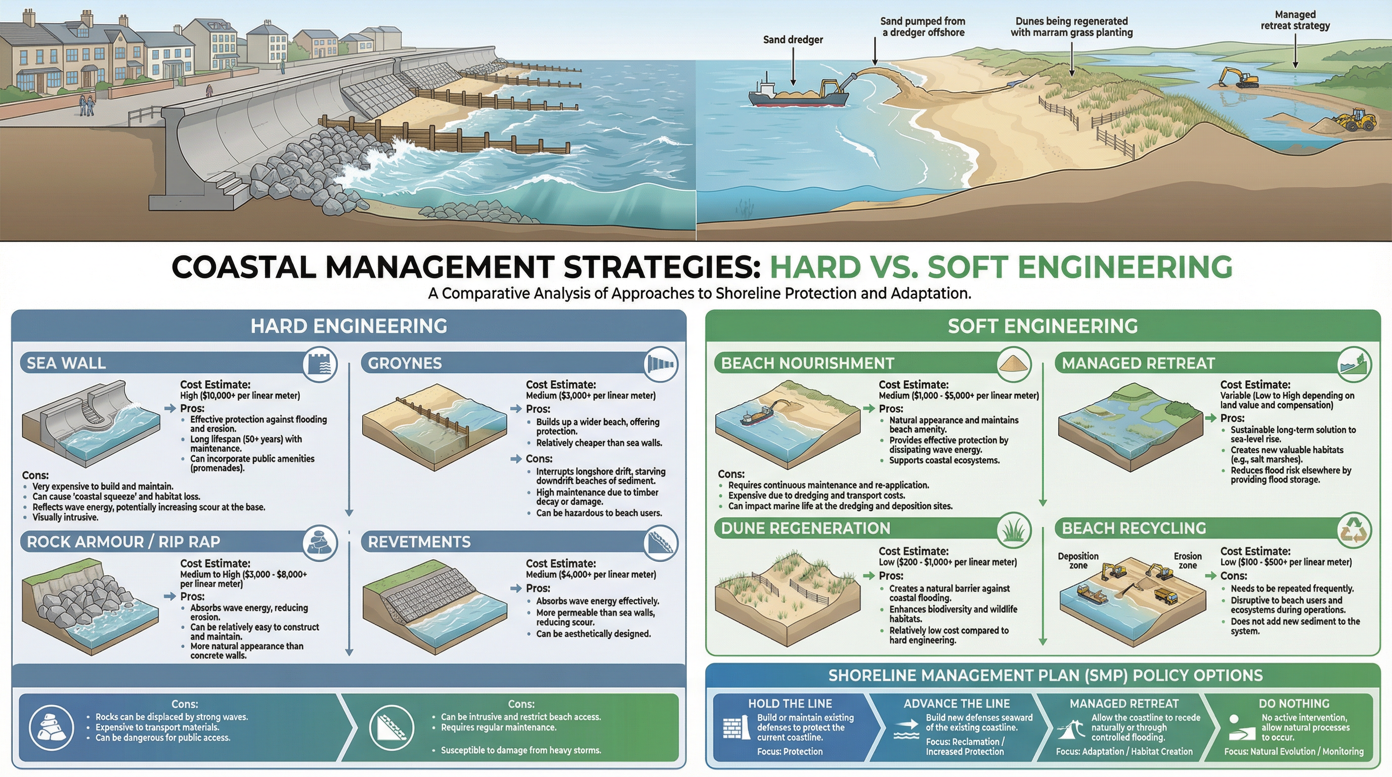
Coastal management strategies are divided into two main types: hard engineering and soft engineering.
### Hard Engineering
These are artificial structures designed to control natural processes. They are often expensive, visually intrusive, and can have negative knock-on effects.
* **Sea Walls**: Concrete or stone walls at the foot of a cliff or top of a beach. They are very expensive but provide excellent protection. Their curved shape reflects wave energy, but this can scour the beach at the base of the wall.
* **Groynes**: Timber or rock structures built at right angles to the coast. They trap sediment being moved by longshore drift, building up the beach. However, by trapping sediment, they starve beaches further down the coast, increasing erosion there. This is a key point for evaluation.
* **Rock Armour (Rip-Rap)**: Large boulders piled up at the base of a cliff. They absorb wave energy effectively and are cheaper than sea walls, but can be unsightly.
### Soft Engineering
These strategies work with natural processes to manage erosion. They are often more sustainable and less visually intrusive.
* **Beach Nourishment**: Adding large quantities of sand or shingle to a beach. This creates a wide, natural-looking beach that absorbs wave energy. It is expensive and needs to be repeated regularly.
* **Dune Regeneration**: Planting marram grass to stabilise dunes. The roots of the grass bind the sand together, and the dunes provide a natural barrier to the sea. This is a low-cost, sustainable option.
* **Managed Retreat**: Allowing the coastline to erode and flood in a controlled way. This is a very controversial but sustainable long-term strategy, creating salt marsh habitats. It is only used in areas of low-value land.
## Named Example Bank: Holderness Coast
* **Location**: East Yorkshire, North East England. Extends for 61km from Flamborough Head to Spurn Head.
* **Geology**: Predominantly soft, unconsolidated boulder clay (till), which offers very little resistance to erosion.
* **Erosion Rate**: The fastest eroding coastline in Europe, retreating at an average of 1.8 metres per year. This results in the loss of around 2 million tonnes of material annually.
* **Mappleton Case Study**: A small village on the Holderness Coast. In 1991, £2 million was spent on two rock groynes and a rock revetment to protect the village and the B1242 coastal road. The scheme has been successful in protecting Mappleton, but has caused sediment starvation downdrift, leading to increased erosion at Great Cowden, where farms and businesses have been lost.
* **Spurn Head**: A classic recurved spit at the southern end of the Holderness Coast, formed by the deposition of sediment transported by longshore drift.
Revision Podcast Transcript
Welcome to GeoRevise — your GCSE Geography podcast. I'm your tutor, and today we're diving deep into one of the most dynamic and visually spectacular topics on the OCR specification: Coastal Landscapes. Whether you're revising for the first time or doing a final check before your exam, this episode has everything you need. We'll cover the key processes, the landforms they create, how humans manage the coast, and — crucially — exactly what your examiner wants to see in your answers. Let's get started.
SECTION ONE: CORE CONCEPTS — COASTAL PROCESSES
The coast is best understood as a system. Inputs include wave energy, sediment, and weathering. Outputs include erosion, transportation, and deposition. Your examiner loves it when you use systems language — it signals geographical thinking rather than just description.
Let's start with waves. Waves are generated by wind blowing across the sea surface. The key distinction you must know is between constructive and destructive waves. Constructive waves have a strong swash and a weak backwash — they build beaches up. Destructive waves have a weak swash and a powerful backwash — they erode material away. Destructive waves are typically high-energy, steep waves associated with exposed coastlines. Remember: Destructive waves Destroy; Constructive waves Construct. Simple, but it works.
Now, erosion. There are four processes, and you must know all four precisely. First, hydraulic action — this is where the sheer force of water, and the compression of air trapped in cracks, breaks apart the rock. Think of it as the wave literally punching the cliff. Second, abrasion — sometimes called corrasion — this is where rock fragments carried by the wave are hurled against the cliff face, acting like sandpaper. This is the most powerful erosional process. Third, attrition — this is where rocks and pebbles carried by the sea knock against each other, becoming smaller and more rounded over time. Notice the difference: abrasion is rock against cliff; attrition is rock against rock. This is one of the most commonly confused pairs in the exam, so fix that distinction in your mind right now. Fourth, solution — also called corrosion — where slightly acidic seawater dissolves soluble minerals in rocks like limestone and chalk.
Moving on to transportation. Sediment is moved along the coast by a process called longshore drift. Waves approach the beach at an angle — the swash carries material up the beach at that angle — but the backwash pulls material straight back down the beach due to gravity. Over many repetitions, material zigzags along the coast in the direction of the prevailing wind. This is absolutely fundamental to understanding depositional landforms like spits and bars.
SECTION TWO: LANDFORMS — EROSIONAL AND DEPOSITIONAL
Let's talk about how these processes create the landforms you need to know.
Erosional landforms. The classic sequence on a headland is: wave-cut notch, cave, arch, stack, stump. Here's the sequence in full. Hydraulic action and abrasion attack the base of a cliff, exploiting weaknesses like joints and bedding planes, to form a wave-cut notch. The notch deepens, the rock above becomes unsupported, and the cliff collapses, retreating landward and leaving a wave-cut platform — the flat rocky area you see at low tide. If the cliff has a weakness on both sides of a headland, two caves form. The caves erode backwards until they meet, forming an arch. The roof of the arch is continually attacked by weathering — freeze-thaw, salt crystallisation — and eventually collapses, leaving an isolated pillar of rock called a stack. The stack is then eroded at its base until it collapses to form a low, flat stump, visible only at low tide.
Your examiner will credit precise sequencing. Don't just say "a stack forms" — explain the process that led to each stage. Use the phrase "Process, Sequence, Result" to structure your answers.
Now, geology matters enormously. A discordant coastline has alternating bands of hard and soft rock running perpendicular to the sea. The soft rock erodes faster, forming bays, while the hard rock resists, forming headlands. This creates the classic headland-and-bay morphology. A concordant coastline has rock bands running parallel to the coast. The outer band of hard rock protects the softer rock behind — until the hard rock is breached, at which point rapid erosion of the soft rock creates a cove. Lulworth Cove in Dorset is the textbook example of this.
Depositional landforms. A spit is a long, narrow ridge of sand or shingle extending from the land into the sea, formed where longshore drift continues past a change in the direction of the coastline — typically at a river mouth or bay. The end of the spit is often curved — a recurved end — caused by secondary wave action from a different direction. Spurn Head on the Holderness Coast is an excellent named example. A bar forms when a spit extends all the way across a bay, enclosing a lagoon behind it. Chesil Beach in Dorset is a famous example of a barrier beach.
SECTION THREE: CASE STUDY — HOLDERNESS COAST
You must have a detailed UK case study. The Holderness Coast in East Yorkshire is the most commonly used and the one OCR examiners expect you to know in detail.
Key facts: The Holderness Coast is the fastest eroding coastline in Europe, retreating at an average rate of approximately 1.7 to 2 metres per year. The soft boulder clay cliffs offer little resistance to wave attack. Since Roman times, over 30 villages have been lost to the sea. The town of Mappleton lost significant land until sea defences were installed in 1991 at a cost of approximately 2 million pounds. These defences — rock groynes and a rock revetment — successfully protected Mappleton, but caused sediment starvation downdrift, accelerating erosion at Great Cowden and other settlements to the south. This is a critical evaluation point: hard engineering in one location can create problems elsewhere.
At the southern end of the Holderness Coast, longshore drift has deposited sediment to form Spurn Head — a recurved spit extending approximately 5.5 kilometres into the Humber Estuary.
Management at Holderness follows a Shoreline Management Plan. The four policy options are: Hold the Line — maintain existing defences; Advance the Line — build new defences seaward; Managed Retreat — allow the coastline to recede; and Do Nothing — no active intervention. At Mappleton, the policy is Hold the Line. At many rural stretches, the policy is Do Nothing or Managed Retreat, as the cost of defence exceeds the value of the land at risk.
SECTION FOUR: EXAM TIPS AND COMMON MISTAKES
Right, this is where we get tactical. Let's talk about exactly how to pick up marks.
Command words. When you see "Describe" — give two or three developed features with supporting evidence. Don't explain, just describe what you see or know. When you see "Explain" — you must give reasons. Use connective language: "this is because", "this leads to", "as a result". When you see "Evaluate" — you must weigh up evidence on both sides and reach a clear, justified conclusion. Never sit on the fence. Your conclusion must state which factor or strategy is more significant and why.
The most common mistakes. Number one: confusing abrasion and attrition. Fix this now — abrasion is rock against cliff; attrition is rock against rock. Number two: giving generic case study information. Don't write "a town on the coast" — write "Mappleton on the Holderness Coast, where 2 million pounds was spent on rock groynes in 1991." Specific data gets you into Level 3. Number three: describing where a landform is rather than explaining how it formed. The examiner wants process, not location. Number four: in management evaluation questions, only saying "it protects homes." You need to discuss sustainability, cost-effectiveness, sediment starvation downdrift, stakeholder conflict between residents, farmers, and environmental groups, and the long-term impact of sea level rise.
For 8 and 12-mark questions, always structure your answer with an introduction that sets up your argument, developed paragraphs with specific evidence, a counter-argument, and a conclusion that directly answers the question with a clear judgement. The examiner is looking for AO2 application and AO3 analysis — not just AO1 knowledge.
SECTION FIVE: QUICK-FIRE RECALL QUIZ
Cover your notes and try these. I'll give you a few seconds for each.
Question one: What is the difference between abrasion and attrition? Pause now. Answer: Abrasion is rock fragments carried by the wave scraping against the cliff face. Attrition is rock fragments colliding with each other in the water, becoming smaller and rounder.
Question two: Name the sequence of erosional landforms on a headland, in order. Pause. Answer: Wave-cut notch, cave, arch, stack, stump.
Question three: What is longshore drift and what does it create? Pause. Answer: Longshore drift is the zigzag movement of sediment along the coast caused by waves approaching at an angle. It creates depositional landforms including spits, bars, and tombolos.
Question four: Give two specific facts about the Holderness Coast. Pause. Answer: It erodes at approximately 1.7 to 2 metres per year — the fastest in Europe. Mappleton was protected by rock groynes in 1991 at a cost of 2 million pounds, but this caused increased erosion downdrift.
Question five: What are the four Shoreline Management Plan policy options? Pause. Answer: Hold the Line, Advance the Line, Managed Retreat, Do Nothing.
SECTION SIX: SUMMARY AND SIGN-OFF
Let's bring it all together. Coastal Landscapes is a topic that rewards students who can do three things: first, explain processes precisely — not just name them; second, use specific case study data — Holderness, Mappleton, Spurn Head, 1.7 metres per year, 2 million pounds; and third, evaluate management critically — going beyond "it protects homes" to discuss sustainability, sediment budgets, stakeholder conflict, and the challenges of sea level rise.
The key memory hook for erosion processes is HASH — Hydraulic action, Abrasion, Solution, attrition with an H for "hitting each other." And for the headland sequence: Never Can A Seal Swim — Notch, Cave, Arch, Stack, Stump.
For your exam, remember: Process leads to Sequence leads to Result. Every explanation answer should follow that structure. And in evaluation questions, always conclude with a clear, justified judgement.
Thank you for listening to GeoRevise. Good luck in your exam — you've got this. Keep revising, keep recalling, and remember: specific knowledge is what separates a Grade 4 from a Grade 8. See you next time.
Key Terms & Definitions
- Discordant Coastline
- A coastline where the geology alternates between bands of hard rock and soft rock which are perpendicular to the coast.
- Concordant Coastline
- A coastline where the rock type runs parallel to the coast. The outer rock is typically more resistant and protects softer rocks inland.
- Sediment Cell
- A largely self-contained stretch of coastline. Sediment is sourced, transported and deposited within the cell, with little movement between adjacent cells.
- Shoreline Management Plan (SMP)
- A large-scale report that assesses the risks associated with coastal processes and sets out a policy to manage those risks for a stretch of coastline.
- Fetch
- The distance of open water over which a wind blows to generate waves.
- Weathering
- The breakdown of rock in situ (without being moved). Key types on the coast are mechanical (e.g., freeze-thaw, salt crystallisation) and chemical (e.g., carbonation).
Worked Examples
-
Worked Example
Question: Explain the formation of a spit. (6 marks)
Solution: **Introduction**: A spit is a depositional landform, created by the process of longshore drift.
**Paragraph 1 - Longshore Drift**: Longshore drift is the process that transports sediment along the coast. The prevailing wind causes waves to approach the beach at an angle. The swash carries material up the beach at this angle. The backwash then pulls material directly back down the beach due to gravity. This results in a net zigzag movement of sediment along the coast.
**Paragraph 2 - Change in Coastline & Deposition**: A spit begins to form where there is an abrupt change in the direction of the coastline, such as at the mouth of an estuary. Longshore drift continues to transport material in its original direction, depositing it out into the open water. Over time, this ridge of deposited sand and shingle builds up and extends further out to sea.
**Paragraph 3 - Recurved End & Salt Marsh**: The end of the spit is often curved inwards towards the land. This is known as a recurved end and is caused by the action of secondary or less dominant waves and winds. In the sheltered, low-energy water behind the spit, mud and silt are deposited, allowing a salt marsh to develop.
-
Worked Example
Question: Using a named example, evaluate the strategies used to manage a coastline. (12 marks)
Solution: **Introduction**: Coastal management involves a range of strategies to protect coastlines from erosion. These can be hard or soft engineering. The Holderness Coast in East Yorkshire provides a clear example of the effectiveness and conflicts associated with these strategies.
**Paragraph 1 - Hard Engineering at Mappleton**: At the village of Mappleton, hard engineering was implemented in 1991 at a cost of £2 million. Two rock groynes and a rock revetment were built to protect the village and a key coastal road. This has been successful in 'holding the line', preventing further erosion and property loss in Mappleton itself. This demonstrates the effectiveness of hard engineering in achieving a specific, local objective.
**Paragraph 2 - Negative Impacts of Hard Engineering**: However, this success came at a cost. The groynes at Mappleton trapped sediment, starving the coast further south. This process, known as terminal groyne syndrome, has significantly increased erosion rates at locations like Great Cowden. Farms and businesses there have been lost to the sea, demonstrating that hard engineering often just moves the problem elsewhere, creating conflict between different stakeholders.
**Paragraph 3 - Soft Engineering & SMPs**: In other areas of the Holderness Coast, a policy of 'Do Nothing' or 'Managed Retreat' is in place, as the cost of protecting low-value agricultural land is not seen as economically viable. This represents a more holistic approach under the Shoreline Management Plan (SMP). While unpopular with those who lose land, it is a more sustainable long-term strategy that allows natural processes to continue and avoids the high cost and negative downstream impacts of hard engineering.
**Conclusion**: In conclusion, the strategies at Holderness show that while hard engineering can be effective in protecting a specific location, it is not a sustainable solution for an entire coastline. It creates significant negative environmental and economic impacts downdrift. Soft engineering and policies like managed retreat, while politically difficult, are more sustainable and work with natural systems. Therefore, the most successful management involves a carefully considered mix of strategies based on land use, value, and an understanding of the entire coastal system, not just isolated locations.
-
Worked Example
Question: Study the OS map extract. Identify the four-figure grid square containing the caravan park. (1 mark)
Solution: The candidate would need to locate the caravan park symbol on the provided (hypothetical) OS map and read the grid lines. For example, if the caravan park is in the square where the easting is 54 and the northing is 31, the answer would be 5431.
Practice Questions
-
Question: Explain how geological structure affects the morphology of a coastline. (6 marks)
Answer:
-
Question: Describe two types of soft engineering used to manage coastlines. (4 marks)
Answer:
-
Question: For a named coastal area you have studied, explain why it is eroding so rapidly. (8 marks)
Answer:
-
Question: ‘Hard engineering is the only way to protect our coasts.’ How far do you agree with this statement? (12 marks + 3 SPaG)
Answer:


