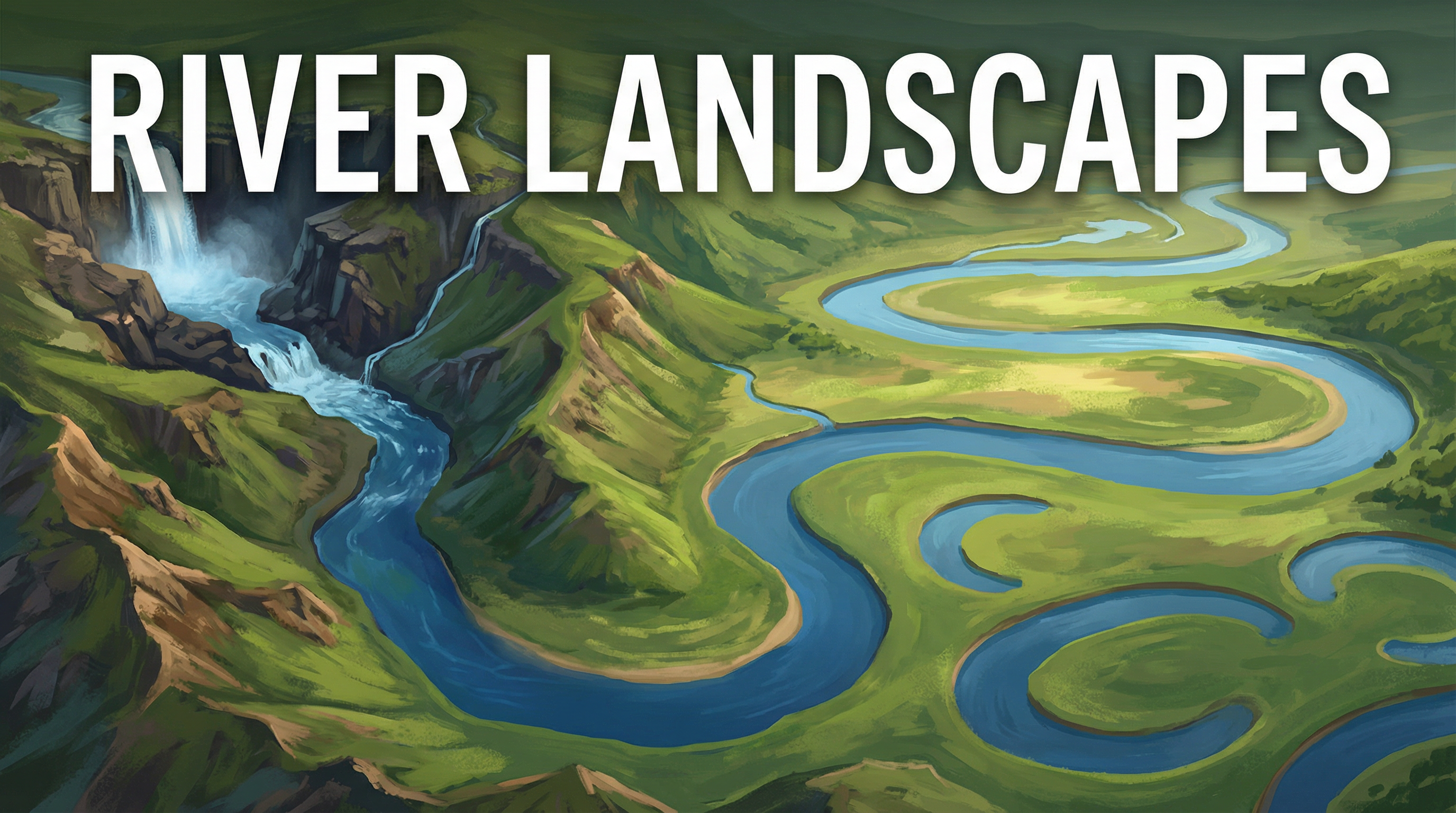
River Landscapes — OCR GCSE Study Guide
Exam Board: OCR | Level: GCSE
This study guide provides a comprehensive, exam-focused overview of River Landscapes for OCR GCSE Geography. It explores the geomorphic processes that shape the land, the resultant landforms, and the human strategies used to manage flood risk, all tailored to secure maximum marks.
## Overview
Welcome to your definitive guide to River Landscapes, a core component of the OCR GCSE Geography specification. This topic requires a systems-based approach, where you must understand the river as a dynamic system of inputs (like precipitation), processes (erosion, transportation, deposition), and outputs (landforms). Examiners expect candidates to link geomorphic processes to the formation of specific landforms in the upper, middle, and lower course of a river. Furthermore, a detailed understanding of a named UK river basin is essential for evaluating flood management strategies. This guide will break down these complex interactions, provide you with the specific knowledge needed for high-level responses, and show you how to apply that knowledge to exam-style questions. Credit is given for precise use of terminology and the integration of specific case study data, which are key differentiators for top-grade answers.
## Key Concepts & Landforms
### The Long Profile & Cross Profile
**What it is**: The long profile is a graph showing the change in the river's gradient from its source to its mouth. It is typically steep in the upper course, gentler in the middle course, and almost flat in the lower course. The cross profile shows a cross-section of the river valley at a certain point.
**Why it matters**: Understanding how these profiles change is fundamental. In the upper course, the cross profile is a narrow, steep-sided **V-shaped valley** due to vertical erosion and mass movement. In the middle course, it becomes wider and more open as lateral erosion dominates. By the lower course, the valley is a very wide, flat-bottomed valley with a large floodplain.
**Specific Knowledge**: Candidates must be able to draw and label these profiles, linking them to the dominant processes.
### Upper Course Landforms
**V-Shaped Valleys & Interlocking Spurs**: Formed by powerful vertical erosion as the river cuts down into its bed. The river lacks the power to erode laterally, so it winds around ridges of hard rock, creating interlocking spurs.
**Waterfalls & Gorges**: These are some of the most dramatic river features. 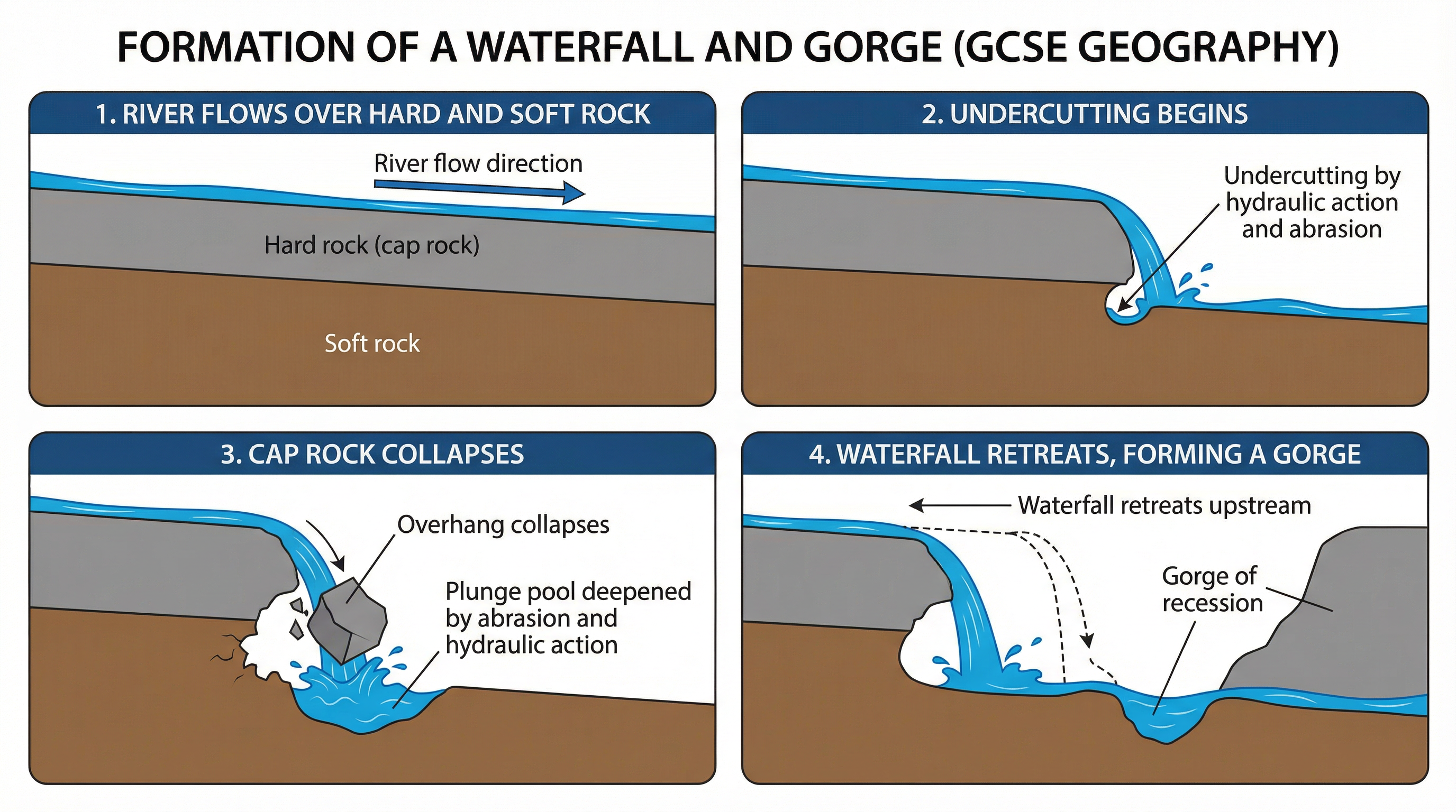 Their formation is a step-by-step process that you must be able to explain in detail.
1. A band of resistant hard rock (the cap rock) lies over a layer of softer, less resistant rock.
2. The river erodes the softer rock more quickly through processes like hydraulic action and abrasion, undercutting the hard rock.
3. This creates an overhang, which eventually collapses under its own weight into the plunge pool below.
4. The collapsed rock grinds away at the plunge pool, deepening it through abrasion.
5. This process repeats, causing the waterfall to retreat upstream, leaving a steep-sided gorge of recession.
**Named Example**: High Force on the River Tees is a 21-metre waterfall formed where the river flows over a resistant band of dolerite rock called the Whin Sill.
### Middle Course Landforms
**Meanders & Oxbow Lakes**: As the river's gradient decreases, lateral erosion becomes the dominant process, creating wide bends called meanders. 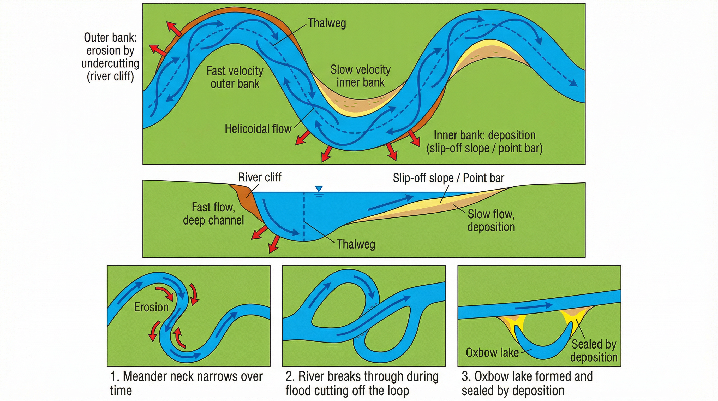
1. The line of fastest flow, the **thalweg**, swings towards the outer bank of a bend.
2. This creates high velocity and energy on the outer bank, leading to erosion (undercutting) and the formation of a steep **river cliff**.
3. On the inner bank, velocity is low, leading to deposition and the formation of a gently sloping **slip-off slope** or point bar.
4. Continued erosion on the outer banks and deposition on the inner banks makes the meander more sinuous (curvy).
5. The neck of the meander narrows over time until, during a flood, the river cuts straight across, abandoning the old loop.
6. Deposition seals off the old loop, forming a crescent-shaped **oxbow lake**.
### Lower Course Landforms
**Floodplains & Levees**: The floodplain is the wide, flat area of land on either side of the river, formed from layers of silt and alluvium deposited during floods. Levees are natural embankments formed along the edges of the river channel. During a flood, the river deposits its heaviest material closest to the channel, building up these banks over time.
**Estuaries**: These are transitional zones where the river meets the sea. They are tidal and contain a mix of fresh and salt water. The UK has many large estuaries, such as the Thames Estuary.
## Flood Management: A UK Case Study
Examiners require you to apply your knowledge to a specific UK river basin to assess flood management. The River Severn is an excellent case study.
### The River Severn
**Why it floods**: It has a large catchment area, impermeable geology in its upper course (Cambrian mountains), and several large urban areas (Shrewsbury, Tewkesbury) built on its floodplain.
**Management Strategies**: A mix of hard and soft engineering is used. 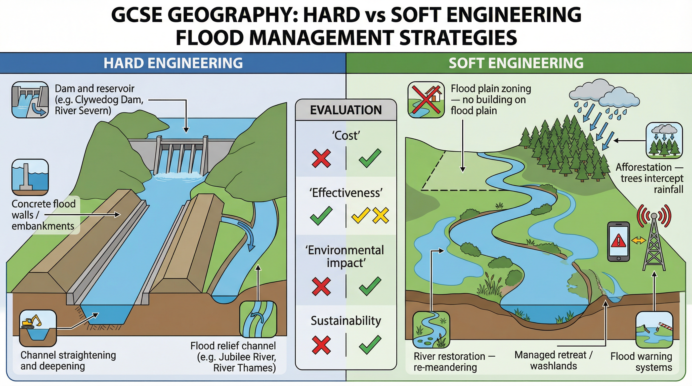
* **Hard Engineering**: The **Clywedog Dam and Reservoir**, built in 1968, stores winter rainfall to reduce flood peaks. In Shrewsbury, concrete flood walls and embankments have been built. These are effective but expensive and visually intrusive.
* **Soft Engineering**: In the upper catchment, **afforestation** schemes have been implemented to increase interception and lag time. **Floodplain zoning** is used to restrict development in high-risk areas. The Environment Agency also operates a sophisticated **flood warning system**.
**Evaluation**: The strategies provide significant protection, but major floods still occur (e.g., 2007, 2020). The debate continues over the cost-effectiveness and environmental impact of hard engineering versus the long-term sustainability of soft engineering.
