Pearson Edexcel · GCSE · Geography
A variety of physical processes interact to shape glaciated upland landscapes
Glaciated upland landscapes are some of the most dramatic and dynamic environments in the UK. This study guide explores how ancient ice rivers carved these relict landscapes, how physical processes continue to shape them today, and how human activities like farming, tourism, and development interact with this fragile environment.
- 6 min read
- 3 worked examples
- 5 practice questions
- 6 key terms
Study Notes
Overview
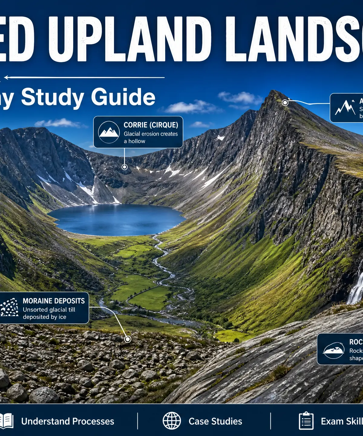
Glaciated upland landscapes in the UK—such as the Lake District, Snowdonia, and the Scottish Highlands—are spectacular 'relict' landscapes. This means they were shaped by massive glaciers during the last ice age, which ended around 10,000 years ago. Today, the ice is gone, but the dramatic landforms it carved remain. For GCSE Geography, examiners expect you to understand not only how these landforms were created by glacial erosion and deposition, but also how current physical processes (like freeze-thaw weathering) continue to modify them. Furthermore, you must evaluate how human activities—from farming and forestry to tourism and renewable energy—interact with these environments, using a specific UK case study (usually the Lake District) to support your answers.
Listen to the comprehensive revision podcast below to master the core concepts:

Key Glacial Processes
Understanding the four main processes is the foundation for explaining any landform:
1. Erosion
Glaciers erode the bedrock primarily through two mechanisms:
- Abrasion: The 'sandpaper' effect. Rocks and debris frozen into the base of the glacier grind against the bedrock as the ice moves, smoothing and scratching (striating) the surface.
- Plucking: Meltwater at the base of the glacier seeps into cracks in the bedrock, refreezes, and locks onto the rock. As the glacier moves, it tears chunks of rock away, leaving a jagged, rough surface.
2. Transport
Glaciers act like giant conveyor belts, moving material in three ways:
- Supraglacial: Material carried on top of the ice (often rockfall from freeze-thaw weathering).
- Englacial: Material carried within the ice.
- Subglacial: Material dragged underneath the ice.
3. Deposition
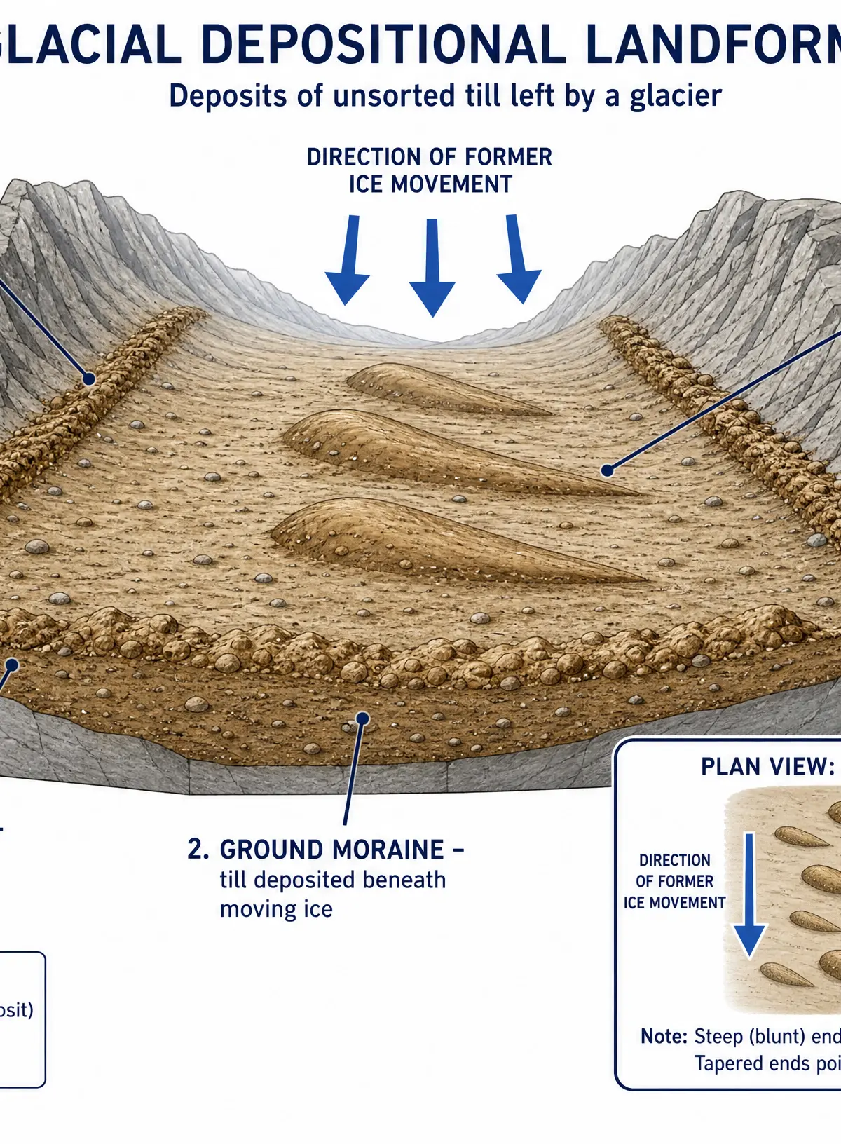
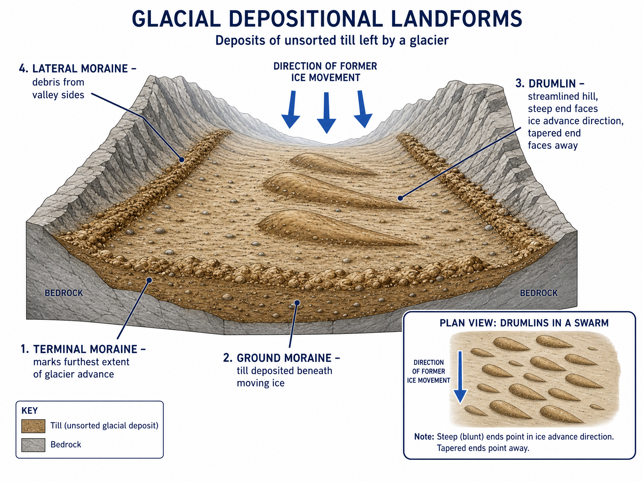
When a glacier melts or loses energy, it drops its load. Material deposited directly by ice is called till (or boulder clay). Crucially, glacial till is unsorted (a jumble of all sizes from clay to massive boulders) and unstratified (not in layers), unlike river deposits.
4. Current Physical Processes (Weathering & Mass Movement)
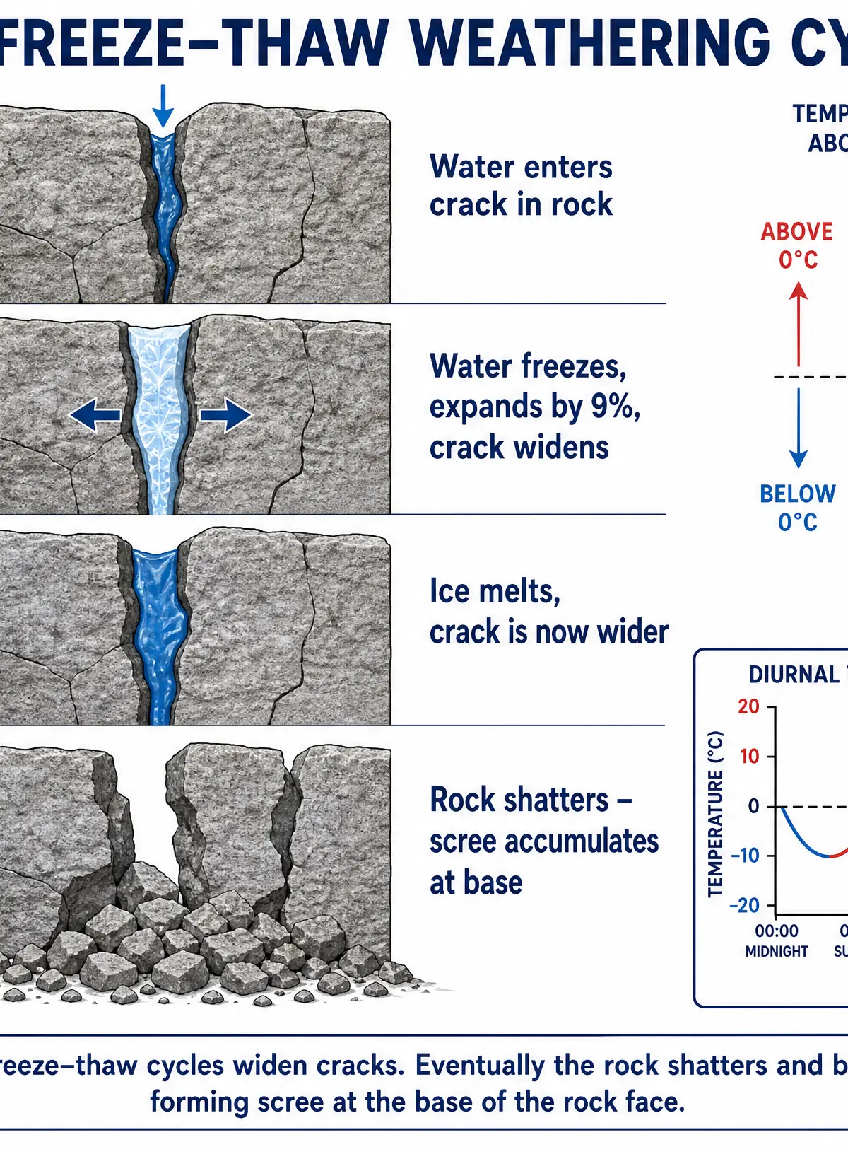
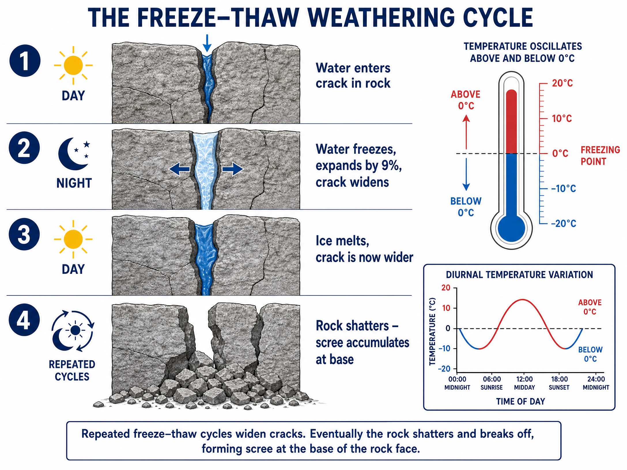
The landscape is still changing today. Freeze-thaw weathering (frost shattering) occurs when water enters cracks, freezes (expanding by 9%), and eventually shatters the rock, creating scree slopes. Mass movement, such as rockfalls and soil creep, continues to shape the steep valley sides.
Erosional Landforms
Erosional landforms are created where the glacier removes material from the landscape.
Corries (Cirques)
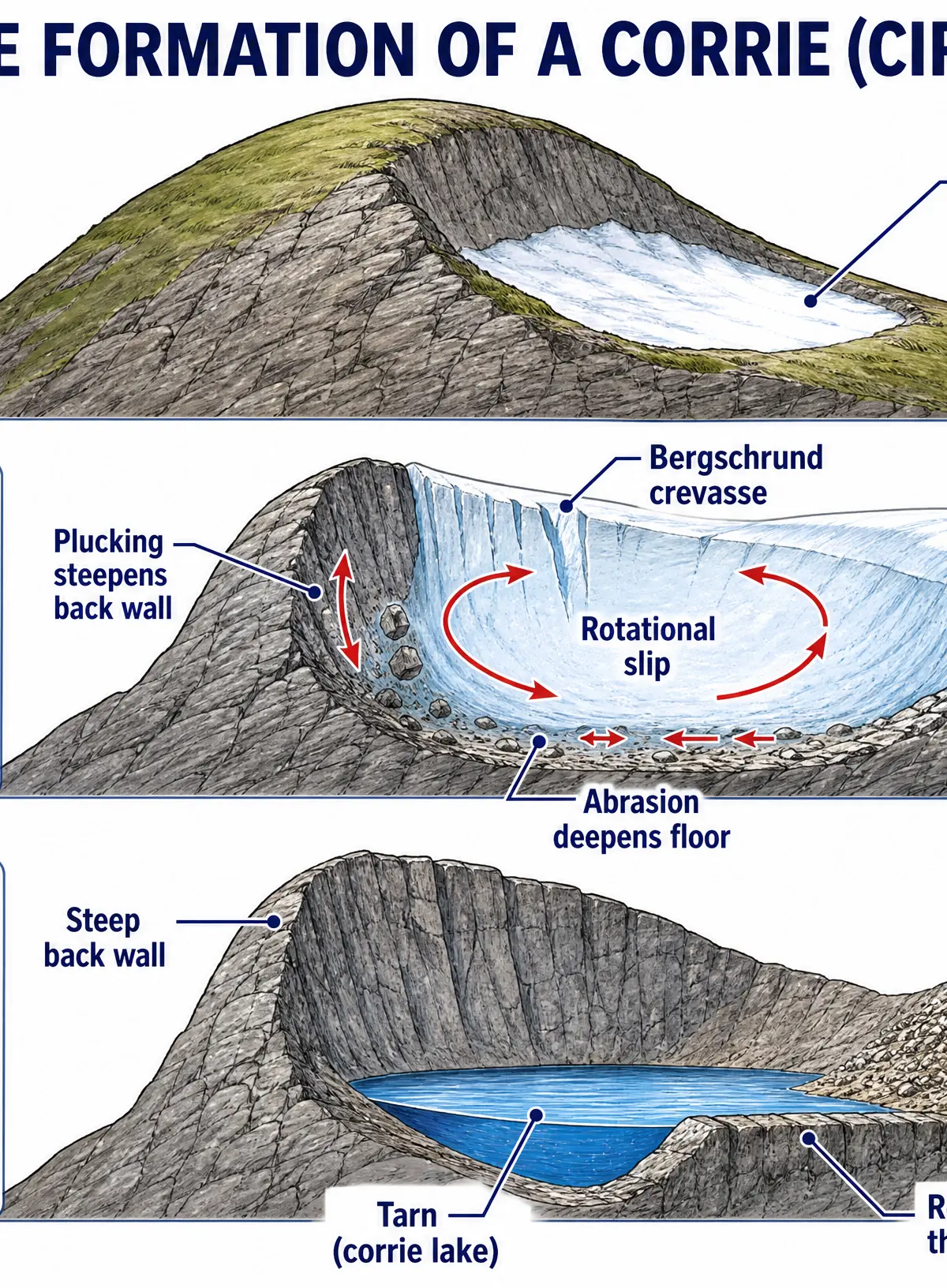
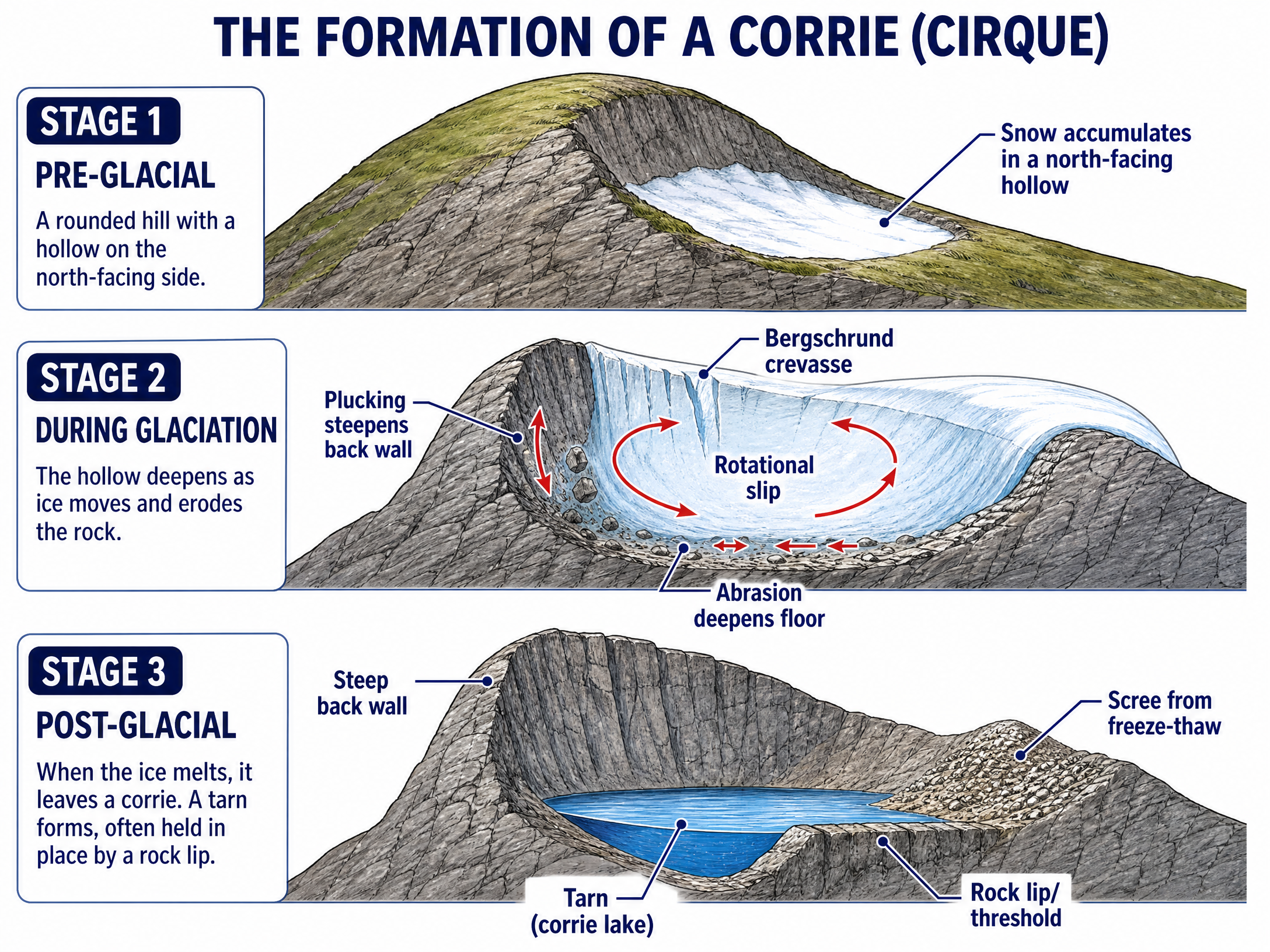
Armchair-shaped hollows high on mountainsides. Snow accumulates in north-facing hollows, compresses into ice, and moves via rotational slip. Abrasion deepens the floor while plucking steepens the back wall. When the ice melts, a small lake called a tarn is often left behind, held by a rock lip.
Arêtes and Pyramidal Peaks
- Arête: A sharp, knife-edged ridge formed when two corries erode back-to-back (e.g., Striding Edge).
- Pyramidal Peak: A sharp, pointed mountain summit formed when three or more corries erode back-to-back (e.g., Snowdon, the Matterhorn).
Glacial Troughs (U-Shaped Valleys)
Glaciers flow down pre-existing V-shaped river valleys. Because glaciers are massive and rigid, they bulldoze straight through, widening and deepening the valley to create a flat floor and steep sides (a U-shape). They cut off interlocking river spurs to create truncated spurs.
Hanging Valleys
Smaller tributary glaciers have less erosive power than the main valley glacier. When the ice melts, the tributary valley is left 'hanging' high above the main valley floor. Waterfalls (e.g., Aira Force) often plunge from these hanging valleys.
Roche Moutonnées
Asymmetrical mounds of resistant bedrock. The upstream (stoss) side is smoothed by abrasion, while the downstream (lee) side is steep and jagged due to plucking.
Depositional and Interaction Landforms
Moraines
Ridges of unsorted glacial till:
- Terminal Moraine: Found at the snout of the glacier, marking its maximum advance.
- Ground Moraine: Till spread across the valley floor as the glacier retreats.
- Lateral Moraine: Ridges of material along the sides of the valley, mostly from freeze-thaw rockfall.
Drumlins
Elongated, egg-shaped hills made of till. The steep (stoss) end faces the direction the ice came from, and the tapered (lee) end points in the direction of ice flow. They often occur in 'swarms' (e.g., Vale of Eden).
Crag and Tail
An interaction landform where a resistant rock outcrop (the crag) protects softer rock behind it from erosion, leaving a gently sloping tail (e.g., Edinburgh Castle).
Human Activity in Glaciated Uplands: The Lake District Case Study
The Lake District in Cumbria is a prime example of a glaciated landscape shaped by human activity.
Opportunities and Impacts
- Farming: Dominated by pastoral sheep farming (Herdwick sheep) on the steep fells. Impact: Overgrazing can cause soil erosion and increase flood risk.
- Forestry: Large conifer plantations (e.g., Grizedale Forest) provide timber. Impact: Non-native conifers reduce biodiversity and look unnatural.
- Water Supply: Deep glacial troughs are ideal for reservoirs (e.g., Thirlmere), supplying water to Manchester. Impact: Dam construction floods habitats and alters the landscape.
- Renewable Energy: Exposed uplands are ideal for wind farms. Impact: High visual pollution in a scenic area.
- Tourism: The biggest industry, attracting 19 million visitors annually and generating £1.2 billion. Impact: Brings jobs and income, but causes traffic congestion, footpath erosion, and high house prices for locals (second homes).
Management and Conservation
Organisations like the Lake District National Park Authority and the National Trust manage the area by repairing footpaths (using local stone), promoting public transport, and restricting controversial developments to protect the fragile environment.
Visual Resources
3 diagrams and illustrations
Interactive Diagrams
1 interactive diagram to visualise key concepts
Conceptual Flow Outline
Flowchart showing the sequence of corrie formation.
Worked Examples
3 worked examples — open one to explore the question and available guidance.
Practice Questions
Test your understanding — click to reveal model answers
Explain how physical processes are currently modifying relict glaciated landscapes. (4 marks)
Hint: Focus on processes happening *today*, not during the ice age. Think about weathering and mass movement.
Describe the characteristics of a drumlin. (3 marks)
Hint: Think about its shape, what it is made of, and how its ends differ.
To what extent do the advantages of tourism in glaciated upland areas outweigh the disadvantages? Use a named example. (9 marks)
Hint: Use the Lake District. Provide clear economic benefits versus environmental/social costs, and conclude with a judgement.
Explain the differences between glacial till and river deposits. (2 marks)
Hint: Think about sorting and shape.
Explain how a glacial trough (U-shaped valley) is formed. (4 marks)
Hint: Start with the pre-glacial landscape and explain how the glacier changes it.