Pearson Edexcel · GCSE · Geography
A variety of physical processes interact to shape river landscapes
Discover the dynamic physical processes that carve our landscape from source to sea. This comprehensive guide covers everything from the dramatic formation of waterfalls to the devastating impacts of flooding, providing you with the exact terminology and case studies examiners demand.
- 7 min read
- 3 worked examples
- 5 practice questions
- 6 key terms
Study Notes
Overview
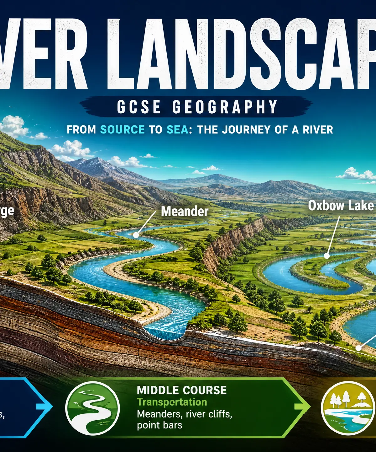
River landscapes are dynamic systems that continuously reshape the Earth's surface. From their source high in the mountains to their mouth at the sea, rivers are engines of change, driven by gravity and the water cycle. For GCSE Geography, understanding rivers is not just about memorising landforms; it's about mastering the physical processes—erosion, transportation, and deposition—that create them. Examiners consistently test your ability to explain how these processes interact over time and why landscapes vary between the upper, middle, and lower courses. Furthermore, you must understand how human activities, such as urbanisation and agriculture, alter river systems, often increasing flood risk, and evaluate the strategies we use to manage these risks. This topic requires precise geographical terminology and the confident use of named case studies, such as the River Tees.
Listen to the companion podcast for a complete audio revision session:

Key Physical Processes
Erosion
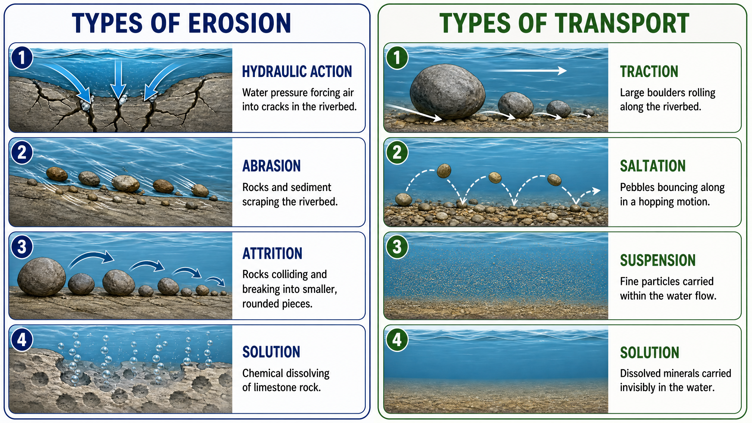
Erosion is the wearing away of rock and soil found along the river bed and banks. It dominates in the upper course where the river has high energy.
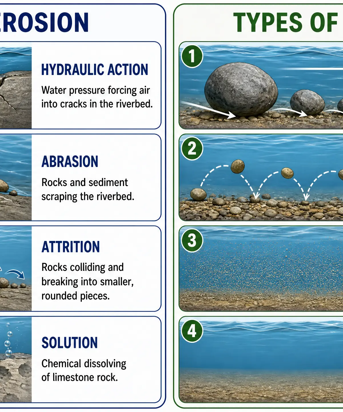
Hydraulic Action: The sheer force of the water crashing against the bed and banks. Air is forced into cracks; when the pressure releases, it acts like a tiny explosion, breaking the rock apart.
Abrasion (Corrasion): The river uses its load (rocks and sediment) as sandpaper, grinding and scraping along the bed and banks. This is the most powerful erosive force.
Attrition: Rocks and pebbles carried by the river collide with each other, breaking into smaller, smoother, and rounder pieces as they move downstream.
Solution (Corrosion): Slightly acidic river water chemically dissolves soluble rocks, such as limestone and chalk.
Transportation
Once material is eroded, the river transports it downstream. The method depends on the size of the particle and the river's energy.
Traction: Large boulders and rocks are rolled along the river bed.
Saltation: Small pebbles and stones bounce along the river bed in a hopping motion.
Suspension: Fine, light material (like silt and clay) is carried within the water, often making it look muddy.
Solution: Dissolved minerals are carried invisibly within the water.
Deposition
Deposition occurs when a river loses energy and drops its load. This typically happens when velocity decreases, such as on the inside of a meander, when the river enters a lake or the sea, or when discharge falls during a dry spell. The heaviest material is deposited first.
Landforms of the River Course
The Upper Course
In the upper course, the gradient is steep, and the channel is narrow and shallow. Vertical erosion dominates, cutting downwards into the landscape.
V-Shaped Valleys and Interlocking Spurs: The river cuts down rapidly, while weathering (like freeze-thaw) weakens the valley sides, causing material to collapse into the river. The river lacks the energy to erode laterally (sideways), so it winds around ridges of hard rock, creating interlocking spurs.
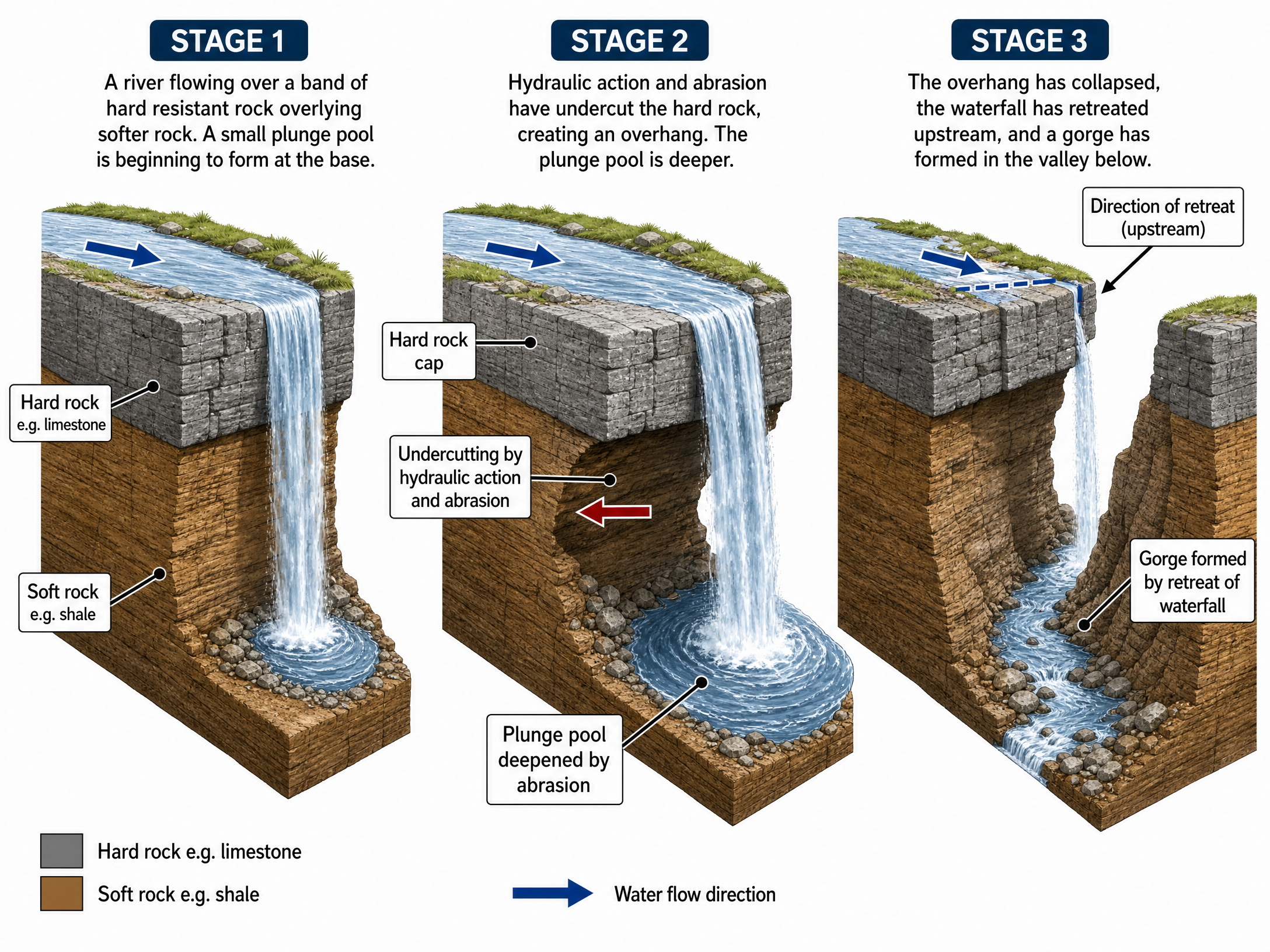
Waterfalls and Gorges:
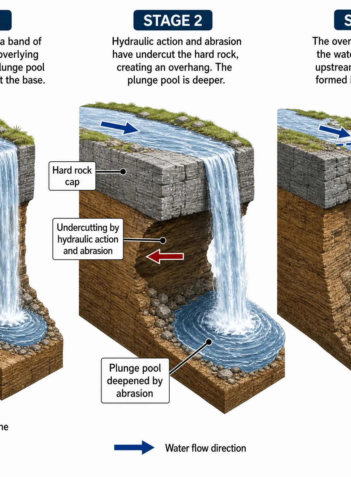
- A river flows over a band of hard, resistant rock overlying softer rock.
- The softer rock is eroded more quickly by hydraulic action and abrasion, undercutting the hard rock to form an overhang.
- A plunge pool develops at the base, deepened by abrasion.
- The unsupported hard rock collapses.
- The waterfall retreats upstream over time, leaving a steep-sided gorge.
The Middle Course
Here, the gradient becomes gentler, and the channel widens. Lateral (sideways) erosion begins to dominate, alongside transportation.
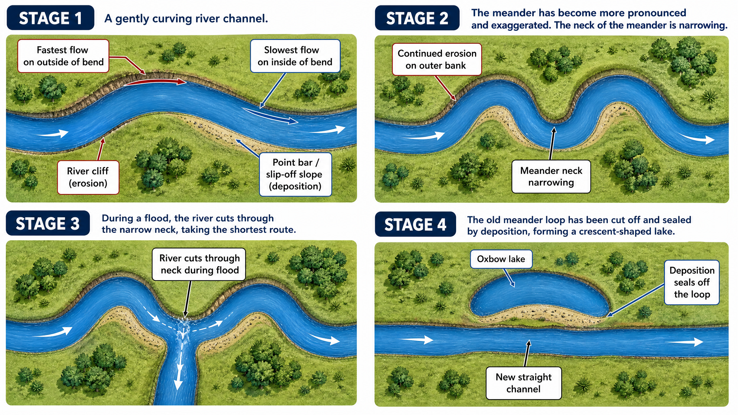
Meanders and Oxbow Lakes:
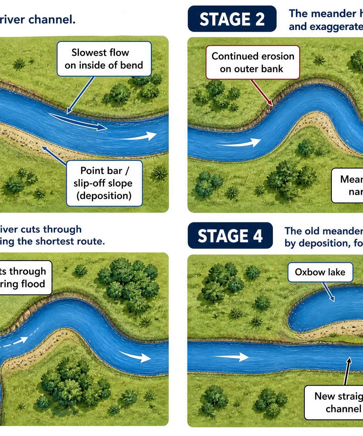
- The river flows faster on the outside of a bend, causing lateral erosion (abrasion and hydraulic action) and forming a river cliff.
- On the inside of the bend, flow is slower, causing deposition and forming a point bar (slip-off slope).
- Over time, the meander neck narrows.
- During a flood, the river cuts through the neck to take the shortest route.
- Deposition seals off the old loop, leaving a crescent-shaped oxbow lake.
The Lower Course
The gradient is almost flat, the channel is very wide and deep, and deposition is the dominant process.
Flood Plains: Wide, flat areas of land either side of the river. When the river floods, it loses velocity and deposits fine silt (alluvium), building up a fertile plain over thousands of years.
Levees: Natural embankments along the river banks. During a flood, the river drops its coarsest, heaviest sediment first (closest to the channel). Repeated flooding builds up these raised banks.
Human Impacts and Flood Management
Human activities often increase flood risk. Urbanisation replaces permeable soil with impermeable concrete and tarmac, increasing rapid surface runoff and decreasing lag time on a hydrograph. Deforestation removes trees that would otherwise intercept rainfall and take up water via transpiration.
Hard Engineering: Artificial structures to control rivers.
- Dams and Reservoirs: Store water to regulate flow (e.g., Kielder Water). Highly effective but expensive and floods land.
- Channelisation: Straightening the channel speeds up flow, moving water away quickly, but increases flood risk downstream.
Soft Engineering: Working with natural processes.
- Flood Plain Zoning: Restricting building on flood-prone land. Cheap and sustainable, but difficult to implement in already developed areas.
- Afforestation: Planting trees to increase interception. Environmentally friendly but takes years to become effective.
Case Study: The River Tees
The River Tees in northeast England is a classic example of a UK river landscape.
- Source: Cross Fell in the Pennines (893m above sea level).
- Upper Course: Features the dramatic High Force waterfall, dropping 21m over the hard Whin Sill rock into a gorge.
- Middle Course: Features prominent meanders near Yarm.
- Lower Course/Mouth: Flows through the heavily industrialised Teesside area into the North Sea, where the channel has been heavily managed and straightened for shipping and flood protection.
Visual Resources
3 diagrams and illustrations
Interactive Diagrams
1 interactive diagram to visualise key concepts
Conceptual Flow Outline
Flowchart showing how human and physical factors combine to increase flood risk.
Worked Examples
3 worked examples — open one to explore the question and available guidance.
Practice Questions
Test your understanding — click to reveal model answers
Explain how physical processes cause a V-shaped valley to form. (4 marks)
Hint: Think about vertical erosion and what happens to the valley sides.
Using a named example, describe the landforms found in the upper course of a river valley. (6 marks)
Hint: Use the River Tees and name at least two specific features.
To what extent do you agree that soft engineering is a better flood management strategy than hard engineering? (9 marks + 3 SPaG)
Hint: You need to evaluate both, using examples, and come to a clear conclusion.
Explain how a river transports its load. (4 marks)
Hint: Remember the 4 types of transport (TSSS).
Explain why deposition occurs in the lower course of a river. (3 marks)
Hint: Think about gradient, velocity, and where the river is going.