Pearson Edexcel · GCSE · Geography
Distinctive river landscapes are the outcome of the interaction between physical and human processes
Master the dynamic forces shaping the UK's rivers. This study guide unpacks how physical erosion and human intervention interact to create distinctive upland and lowland landscapes, securing vital marks in your GCSE Geography exam.
- 5 min read
- 3 worked examples
- 5 practice questions
- 6 key terms
Study Notes

Overview
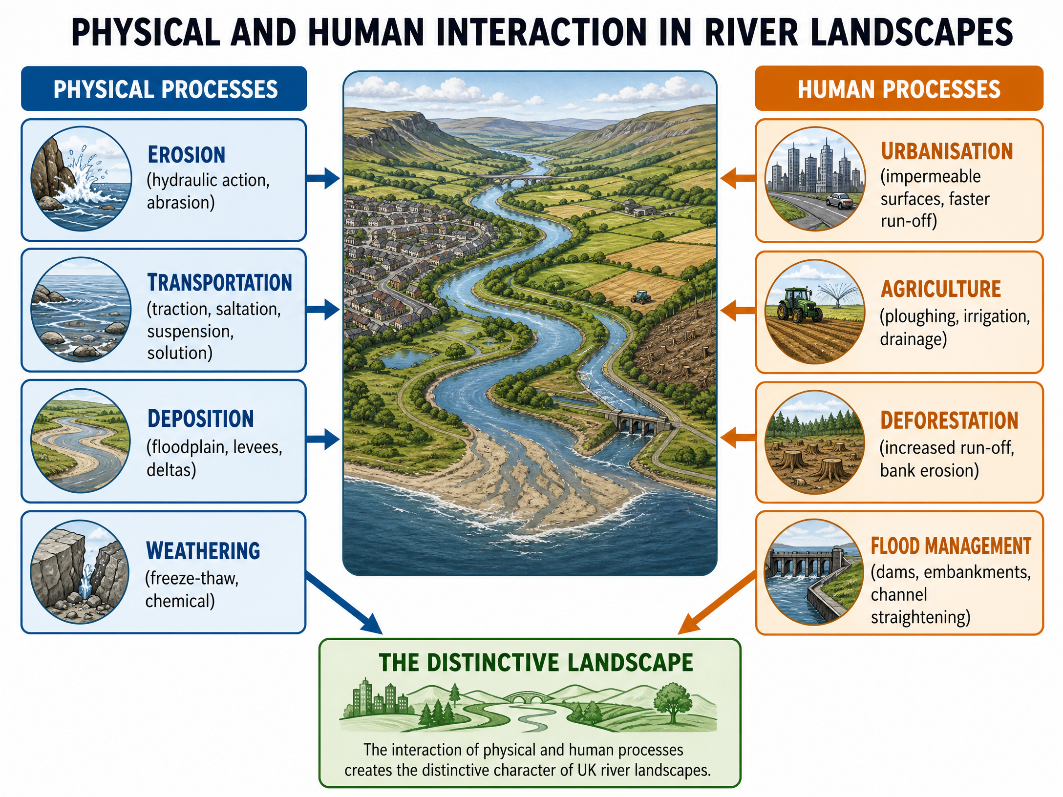
Distinctive river landscapes are formed by a complex interplay of physical processes (erosion, transportation, deposition) and human activities (urbanisation, agriculture, river management). For GCSE Geography, examiners expect candidates to do more than simply describe these processes in isolation; you must demonstrate how they interact to create specific, named landscapes in the UK. This topic is heavily assessed across all major exam boards, typically through extended writing questions (AO2/AO3) where named examples and balanced evaluation are critical for reaching Level 3 and Level 4 marks.
Listen to the Podcast

Physical Processes
Erosion
Erosion is the wearing away and removal of material by a moving force, such as a river. In the upper course, vertical erosion dominates, creating steep, V-shaped valleys.
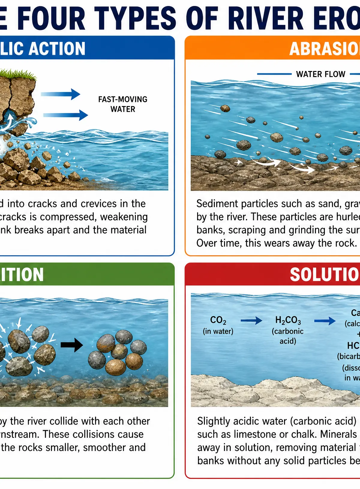
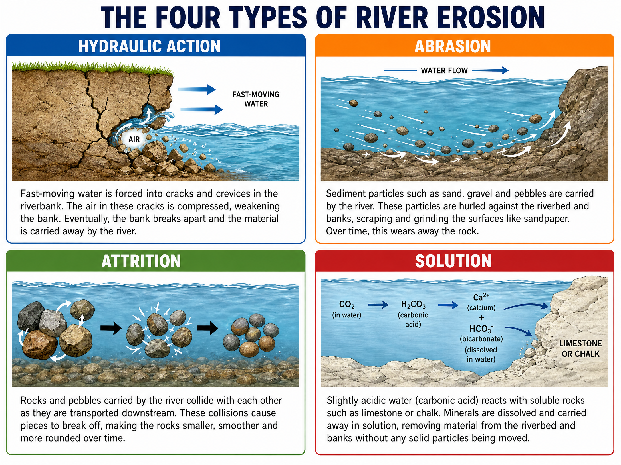
Hydraulic Action: The sheer force of fast-flowing water forces air into cracks in the riverbank. The air is compressed, weakening the bank until pieces break off.
Abrasion: Sand, gravel, and pebbles carried by the river scrape and grind against the riverbed and banks like sandpaper, wearing them away.
Attrition: Rocks and pebbles carried by the river collide with each other, breaking into smaller, smoother, and rounder pieces over time.
Solution: Slightly acidic river water reacts with soluble rocks, such as limestone or chalk, dissolving the minerals and carrying them away in solution.
Transportation
Once material is eroded, the river transports it downstream. The method depends on the size of the particle and the energy of the river.
Traction: Large boulders and rocks are rolled along the riverbed by the force of the water.
Saltation: Smaller pebbles and stones are bounced along the riverbed in a leap-frogging motion.
Suspension: Fine, light material (like silt and clay) is carried within the flow of the water, often making the river look muddy.
Solution: Dissolved minerals are carried invisibly within the water.
Deposition
Deposition occurs when a river loses energy and drops the material it is carrying. This happens when the river enters a lake or sea, when the channel widens or becomes shallower, or on the inside of a meander bend.
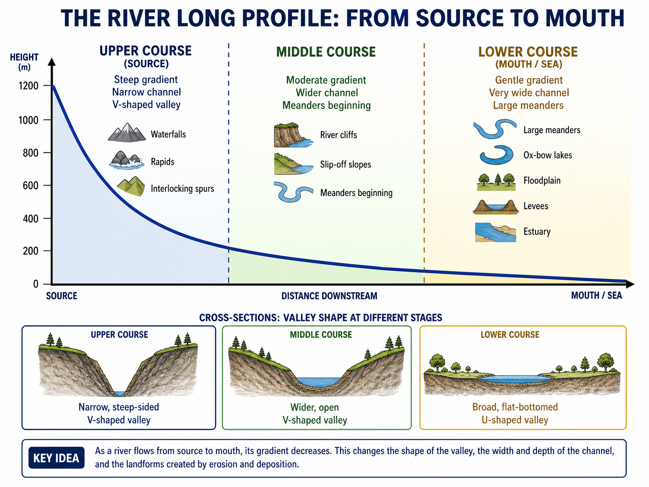
The River Long Profile
As a river flows from its source to its mouth, its gradient, channel shape, and valley shape change significantly. This is known as the long profile.
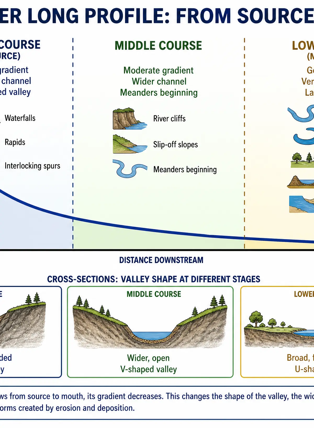
Upper Course: Steep gradient, narrow and shallow channel, V-shaped valley. Features include waterfalls, gorges, and interlocking spurs. (e.g., High Force on the River Tees).
Middle Course: Moderate gradient, wider and deeper channel, wider valley. Features include meanders and river cliffs.
Lower Course: Gentle gradient, very wide and deep channel, broad flat U-shaped valley. Features include large meanders, ox-bow lakes, floodplains, and levees. (e.g., the River Severn floodplain).
Human Interaction with the Landscape
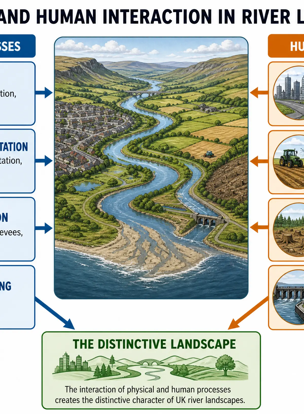
Examiners heavily reward candidates who can link physical processes to human activities.
Urbanisation
Building cities and towns on floodplains replaces natural, permeable surfaces (like soil and grass) with impermeable surfaces (like tarmac and concrete). Rainwater cannot infiltrate the ground, so surface run-off increases. Water reaches the river channel much faster, leading to a shorter lag time, higher peak discharge, and increased flood risk. This can accelerate bank erosion and alter the channel shape.
Agriculture
Farming practices significantly impact river landscapes. Overgrazing by sheep in upland areas (like the Pennines) removes vegetation cover. Without roots to bind the soil, surface run-off and soil erosion increase. This washes sediment into the river, increasing its load and altering deposition rates downstream. Furthermore, agricultural drainage schemes designed to dry out fields can artificially speed up the movement of water into the river system.
Deforestation
Removing trees in a river catchment reduces interception (rainwater caught by leaves) and root uptake. This means more water hits the ground directly and runs off into the river, increasing flood risk and soil erosion.
River Management
Hard engineering strategies physically alter the landscape. Channelisation (straightening the river) speeds up the flow of water to protect a specific area from flooding, but this transfers the flood risk and increased erosive power downstream. Dams and reservoirs (like Kielder Water) regulate river flow but trap sediment behind the dam. This starves the river downstream of its natural load, causing it to erode its own bed more aggressively (channel incision).
Visual Resources
3 diagrams and illustrations
Interactive Diagrams
1 interactive diagram to visualise key concepts
Conceptual Flow Outline
Step-by-step formation of a waterfall and gorge.
Worked Examples
3 worked examples — open one to explore the question and available guidance.
Practice Questions
Test your understanding — click to reveal model answers
Explain how the shape of a river valley changes downstream. (4 marks)
Hint: Think about the transition from the upper course to the lower course, and mention vertical vs lateral erosion.
Assess the extent to which human activities are the main cause of flooding in a named UK river valley. (9 marks)
Hint: You need a named example. Discuss human causes (urbanisation, deforestation), but balance this by assessing physical causes (heavy rainfall, geology). Reach a conclusion.
Describe the process of saltation. (2 marks)
Hint: This is a transportation process. Think about the size of the material and how it moves.
Explain the formation of an ox-bow lake. (4 marks)
Hint: Start with a meander, explain erosion and deposition, and mention what happens during a flood.
State one human cause and one physical cause of a river changing its course. (2 marks)
Hint: Think of a natural process and an artificial intervention.