Pearson Edexcel · GCSE · Geography
Erosion and deposition interacting with geology create distinctive landforms in river landscapes
Discover how rivers shape the landscape from source to mouth through erosion, transportation, and deposition. This essential GCSE Geography topic explains the formation of dramatic features like waterfalls and meanders, and how underlying geology controls their development.
- 5 min read
- 3 worked examples
- 5 practice questions
- 6 key terms
Study Notes
Overview
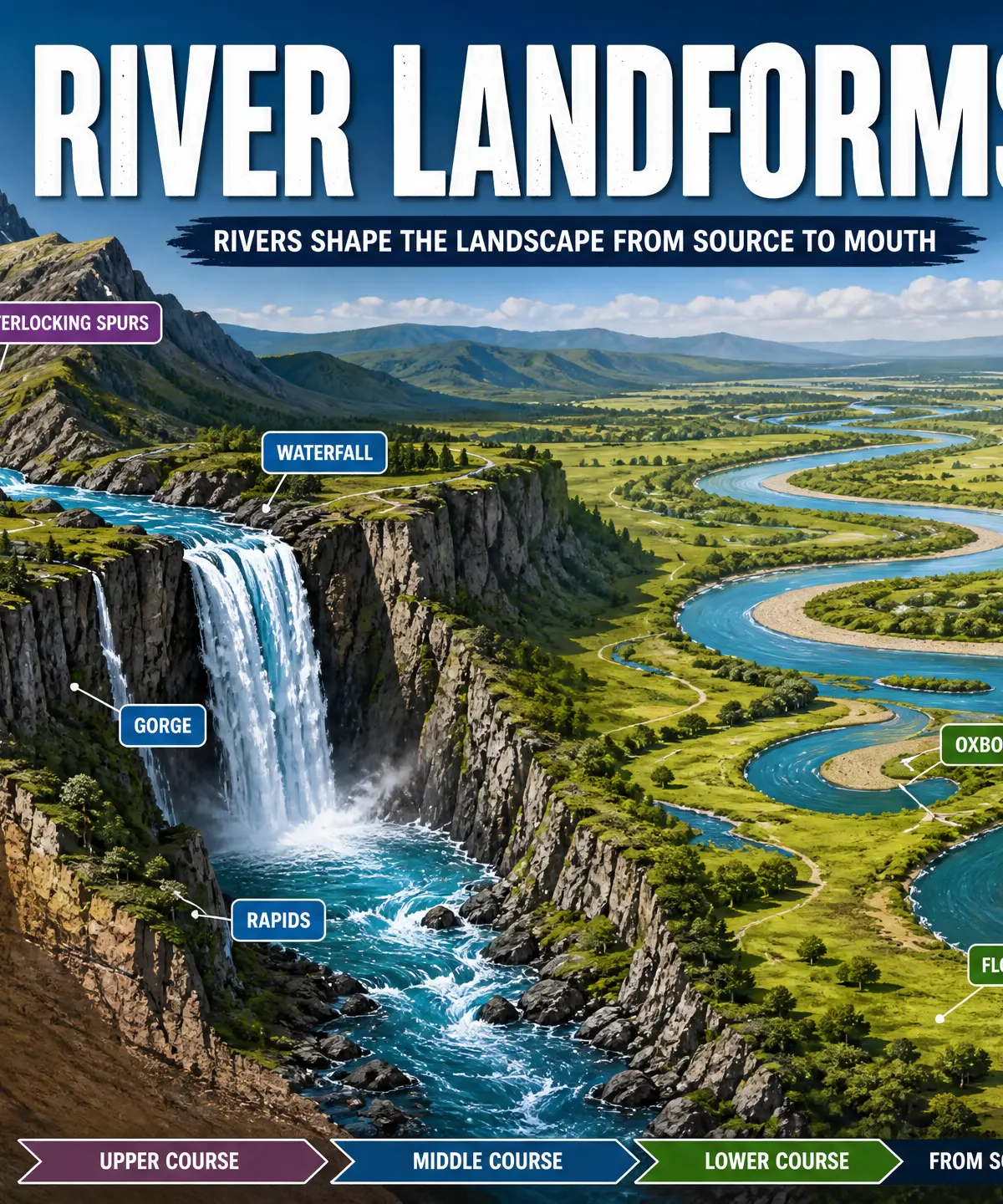
This study guide covers the dynamic processes that shape river landscapes. From the steep, energetic upper course to the wide, flat lower course, rivers are constantly at work eroding, transporting, and depositing material. Examiners expect candidates to not only describe the distinctive landforms created—such as waterfalls, gorges, meanders, and oxbow lakes—but to explain how and why they form. Crucially, you must understand the interaction between these river processes and the underlying geology. The contrast between hard, resistant rock and softer, easily eroded rock is the key to explaining features like interlocking spurs and waterfalls. This topic is heavily tested in GCSE Geography, often requiring annotated diagrams and specific named examples.
Key River Processes
Erosion
Definition: The wearing away of the river bed and banks.
Key Types:
- Hydraulic action: The sheer force of the water hitting the river banks, compressing air into cracks and breaking the rock apart.
- Abrasion: Sand and stones carried by the river scrape against the bed and banks like sandpaper.
- Attrition: Rocks and pebbles carried by the river crash into each other, becoming smaller and rounder.
- Solution: Slightly acidic river water dissolves soluble rocks like limestone and chalk.
Transportation
Definition: The movement of eroded material downstream.
Key Types:
- Traction: Large boulders roll along the river bed.
- Saltation: Smaller pebbles bounce along the river bed.
- Suspension: Fine, light material (silt and clay) is carried within the water.
- Solution: Dissolved minerals are carried invisibly in the water.
Deposition
Definition: The dropping of material when a river loses energy.
Why it happens: Deposition occurs when velocity drops—for example, on the inside of a meander bend, when the river overflows onto a flood plain, or when it enters the sea or a lake.
Landforms of the Upper Course
Interlocking Spurs
In the upper course, the river lacks the energy to erode laterally (sideways). It mainly erodes vertically, cutting a deep V-shaped valley. Because it cannot cut through areas of hard, resistant rock, the river winds around them, creating a series of alternating ridges that interlock like the teeth of a zip.
Waterfalls and Gorges
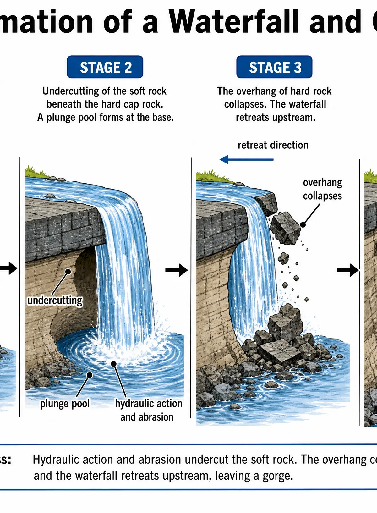
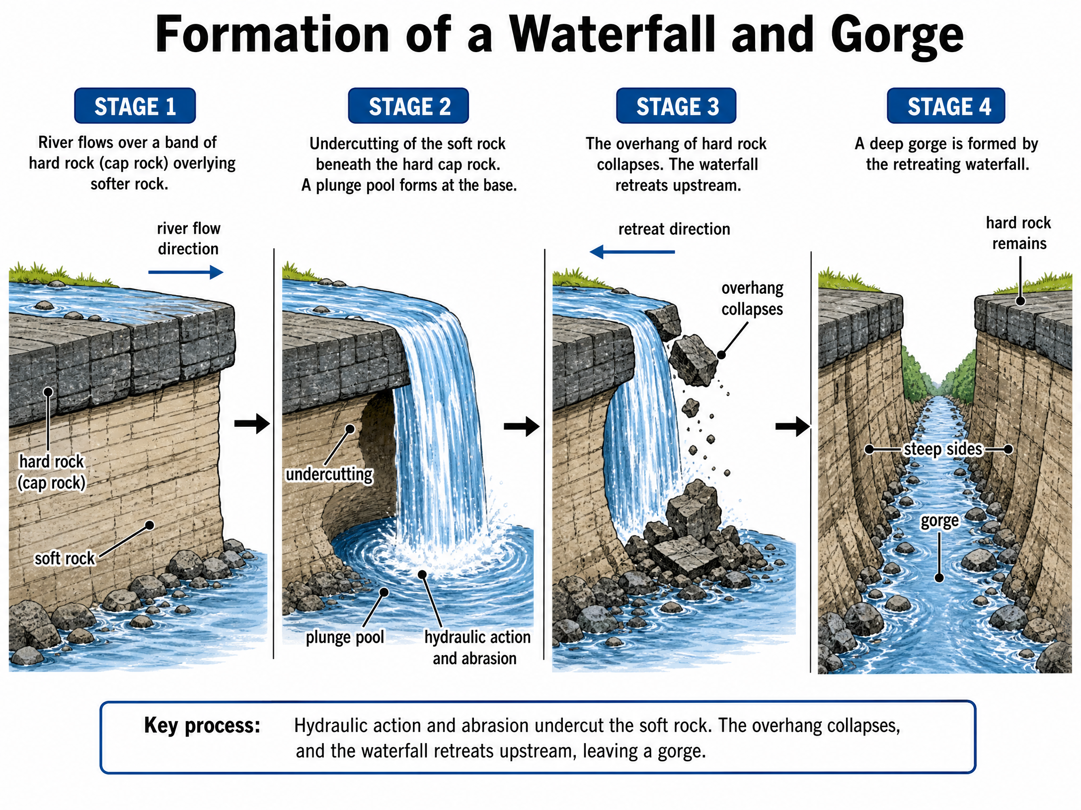
Waterfalls form where a river flows over an area of hard rock (cap rock) overlying softer rock. The soft rock is eroded more quickly by hydraulic action and abrasion, undercutting the hard rock and creating a plunge pool. The hard rock overhang eventually collapses. As this process repeats, the waterfall retreats upstream, leaving behind a steep-sided gorge.
Landforms of the Middle and Lower Course
Meanders and Oxbow Lakes
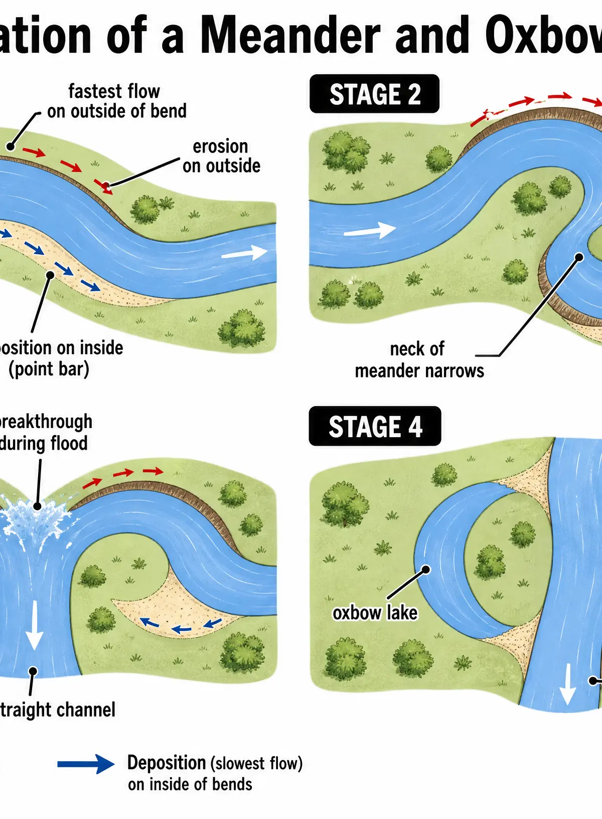
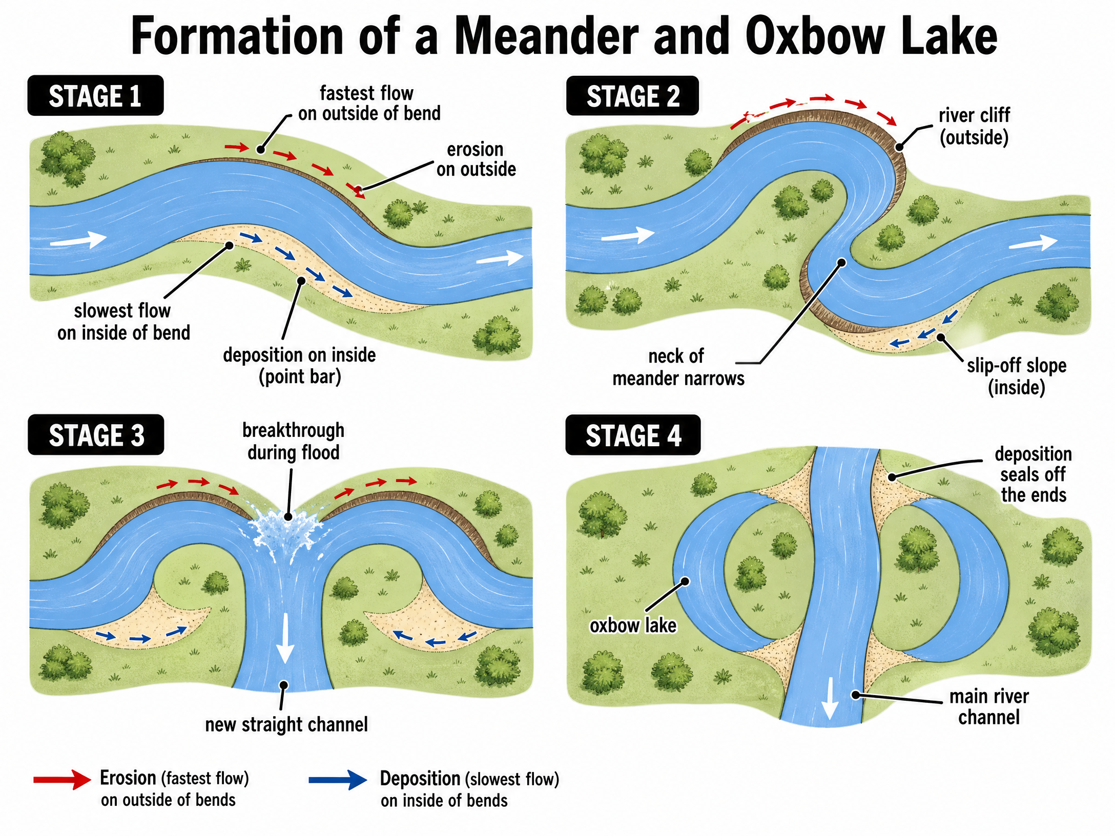
Meanders are sweeping bends in the river. Water flows fastest on the outside of the bend, causing lateral erosion (abrasion and hydraulic action) which forms a river cliff. Water flows slowest on the inside of the bend, causing deposition which forms a gently sloping slip-off slope (point bar). Over time, the neck of the meander narrows. During a flood, the river breaks through the neck, taking the shortest route. Deposition seals off the old loop, creating a horseshoe-shaped oxbow lake.
Flood Plains and Levees
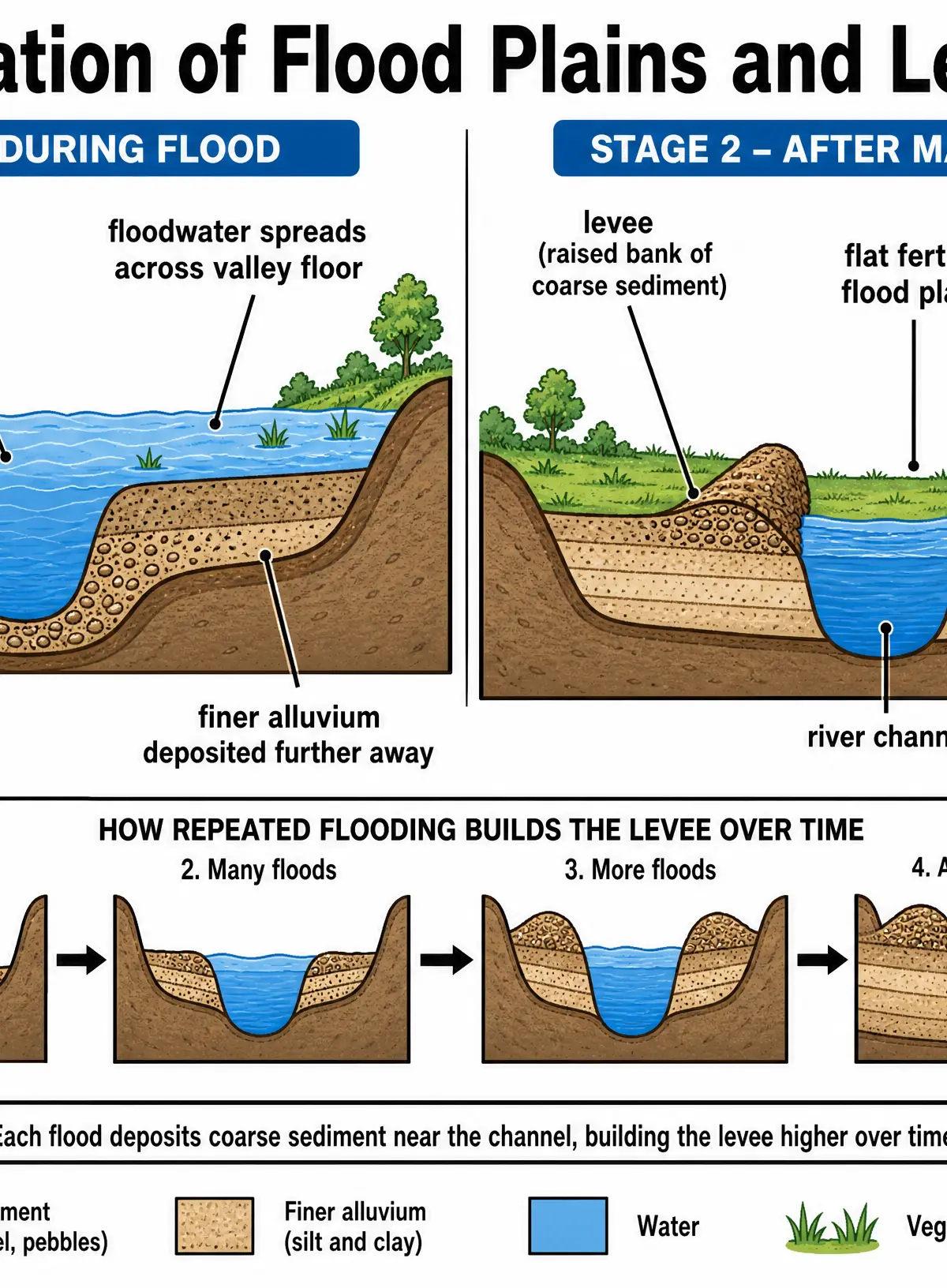
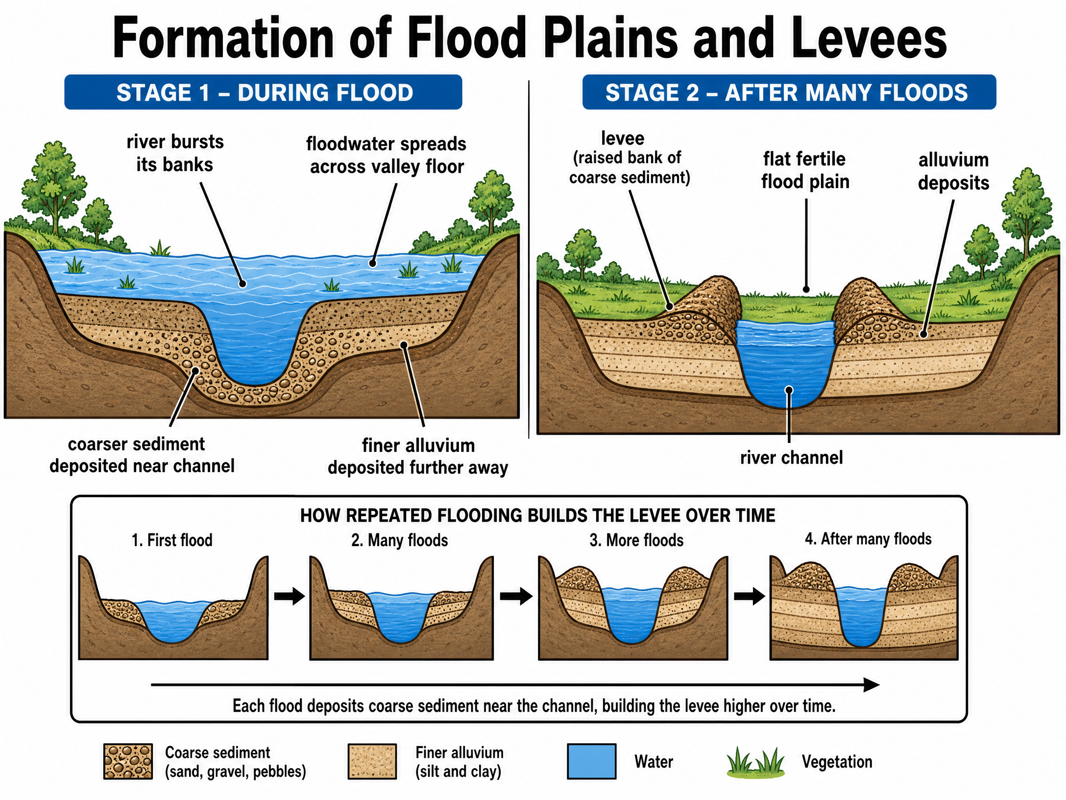
The flood plain is the wide, flat valley floor in the lower course, created by lateral erosion of meanders and the deposition of fine alluvium during floods. Levees are raised natural embankments along the river channel. When a river floods, it overflows its banks, loses velocity, and immediately deposits its heaviest, coarsest sediment close to the channel. Finer sediment is carried further away. Repeated flooding builds the levees higher over time.
Audio Revision
Listen to our 10-minute podcast episode covering all these concepts in detail, complete with exam tips and a quick-fire quiz:

Visual Resources
3 diagrams and illustrations
Interactive Diagrams
1 interactive diagram to visualise key concepts
Conceptual Flow Outline
Flowchart of Waterfall Formation
Worked Examples
3 worked examples — open one to explore the question and available guidance.
Practice Questions
Test your understanding — click to reveal model answers
Explain the formation of an oxbow lake. (6 marks)
Hint: Start with a meander. Mention where erosion and deposition happen, how the neck narrows, and what happens during a flood.
Using a named example, explain how geology influences the formation of a waterfall. (4 marks)
Hint: You must name a specific waterfall and the specific rock types involved.
Explain why interlocking spurs are found in the upper course of a river. (3 marks)
Hint: Think about the river's energy and what type of erosion is dominant near the source.
Describe two features of a flood plain. (2 marks)
Hint: Command word is 'describe', so just say what it looks like or what it's made of.
Explain how levees are formed. (4 marks)
Hint: Focus on what happens to velocity and sediment size when a river floods.