Pearson Edexcel · GCSE · Geography
Glacial erosion and deposition create distinctive landforms within glaciated upland landscapes
Discover how massive sheets of ice sculpted the dramatic peaks and deep valleys of the UK's glaciated uplands. This study guide covers the powerful processes of glacial erosion and deposition, the distinctive landforms they create, and how humans interact with these spectacular but fragile environments today.
- 10 min read
- 3 worked examples
- 5 practice questions
- 6 key terms
Study Notes
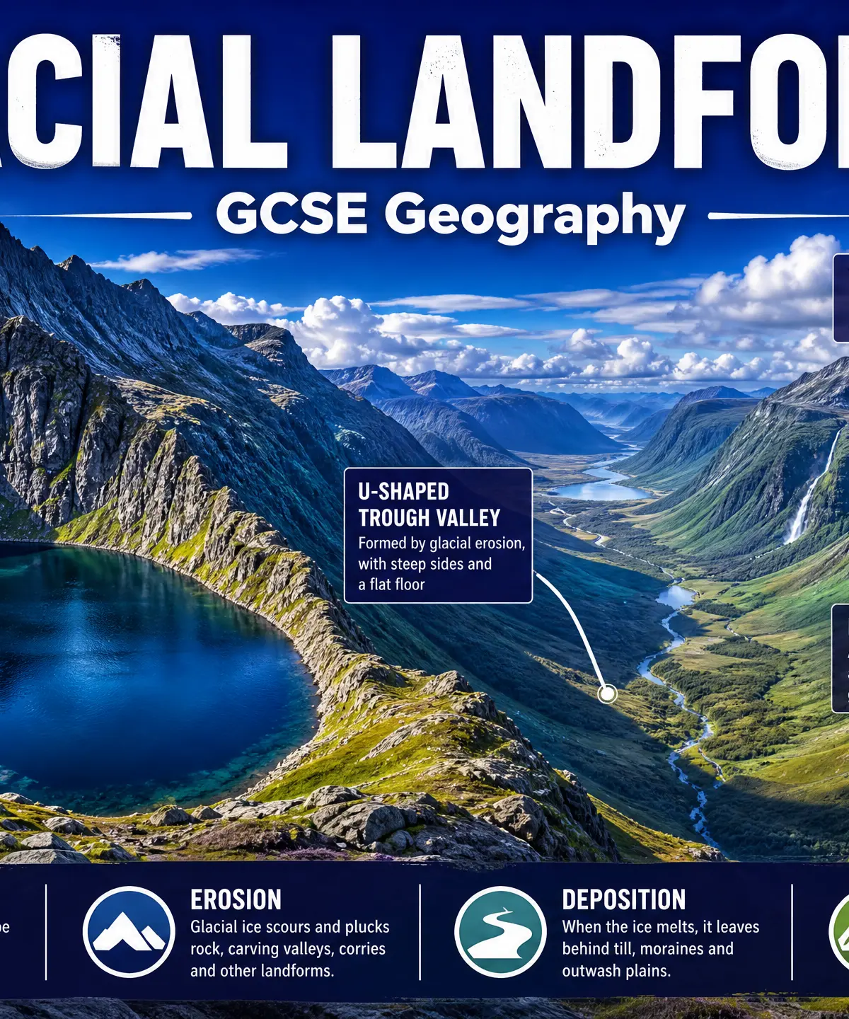
Overview
This study guide covers the incredible power of ice in shaping the landscape. During the last Ice Age, which ended approximately 10,000 years ago, much of the UK was covered by thick ice sheets and glaciers. These massive rivers of ice acted like giant bulldozers, carving out the dramatic glaciated upland landscapes we see today in places like the Lake District, Snowdonia, and the Scottish Highlands.
For your GCSE Geography exam, you need to understand the physical processes of glacial erosion (abrasion and plucking) and deposition, and how these processes create distinctive landforms. Examiners expect you to be able to explain the step-by-step formation of features like corries, arêtes, glacial troughs, and moraines. Furthermore, you must understand how human activities—such as farming, forestry, tourism, and water management—interact with these environments, bringing both economic benefits and environmental challenges.
Listen to our revision podcast to reinforce your learning:

Key Glacial Processes
Erosion Processes
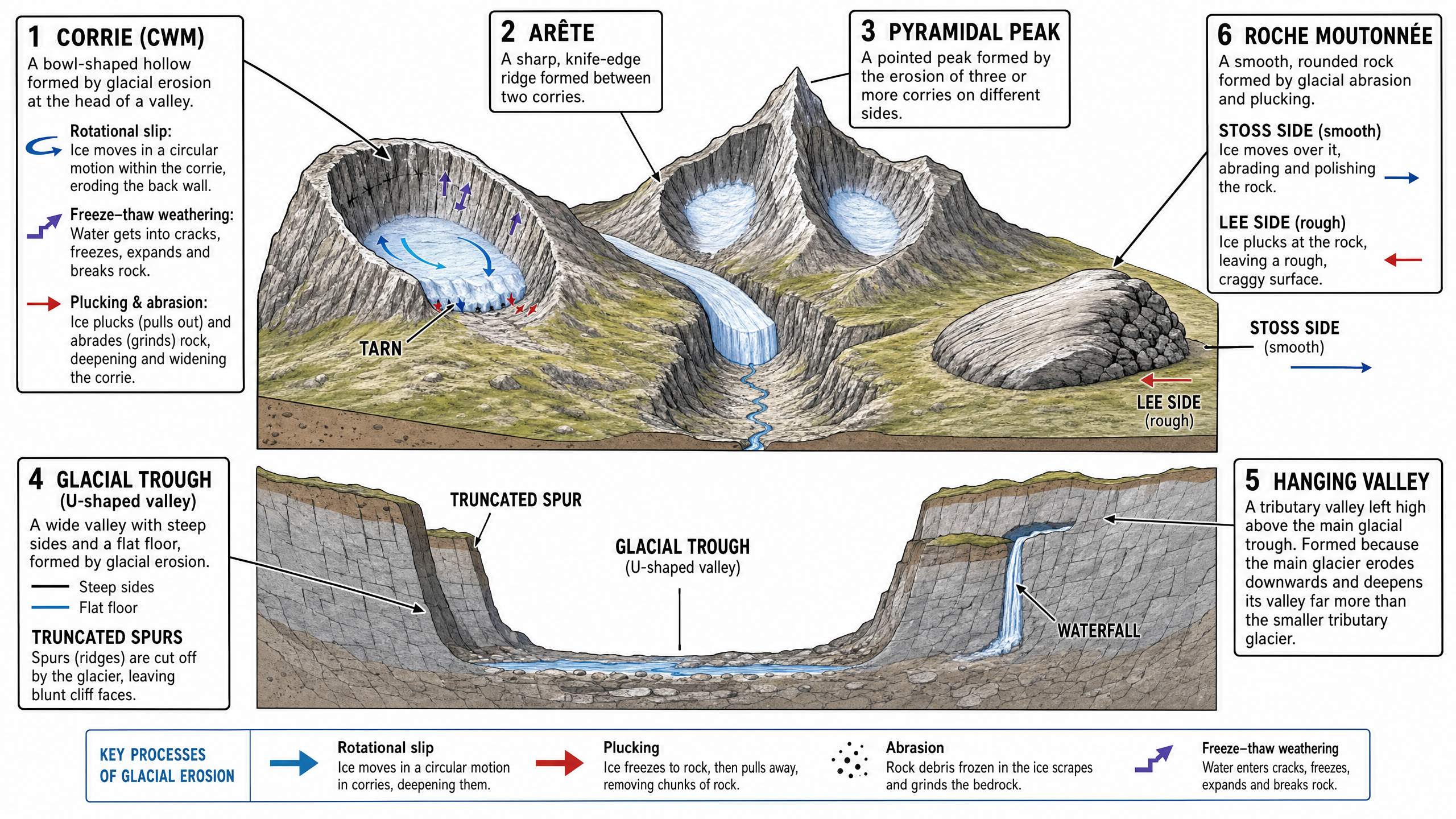
Abrasion: Think of this as the glacier acting like giant sandpaper. Rock fragments and debris become frozen into the base and sides of the glacier. As the heavy ice moves downhill, these fragments scrape, grind, and scour the bedrock below, wearing it away and leaving a smooth, polished surface often marked with deep scratches called striations.
Plucking (Quarrying): This occurs when meltwater at the base of the glacier seeps into cracks in the underlying bedrock. The water refreezes, bonding the ice to the rock. As the glacier moves forward, it literally rips or 'plucks' chunks of rock away from the bedrock. This creates a rough, jagged, and craggy surface.
Freeze-Thaw Weathering: While not strictly a glacial process, it operates in cold, mountainous environments. Water enters cracks in the rock during the day. At night, temperatures drop below freezing, causing the water to turn to ice and expand by about 9%. This expansion widens the crack. Repeated cycles of freezing and thawing eventually cause pieces of rock to break off entirely. This broken rock (scree) falls onto the glacier and provides the tools for abrasion.
Rotational Slip: This is the circular movement of ice in a corrie hollow. The ice pivots around a central point, causing severe erosion on the back wall and over-deepening the corrie floor.
Deposition Processes
When a glacier melts (often referred to as retreating), it loses its energy and drops the material it has been carrying. This material is called till (or boulder clay). Till is unsorted, meaning it contains a mixture of all sizes of material, from fine clay particles to massive boulders, dumped randomly together. It is also unstratified (not in layers) and the rocks are often angular because they haven't been smoothed by water action.
Distinctive Erosional Landforms
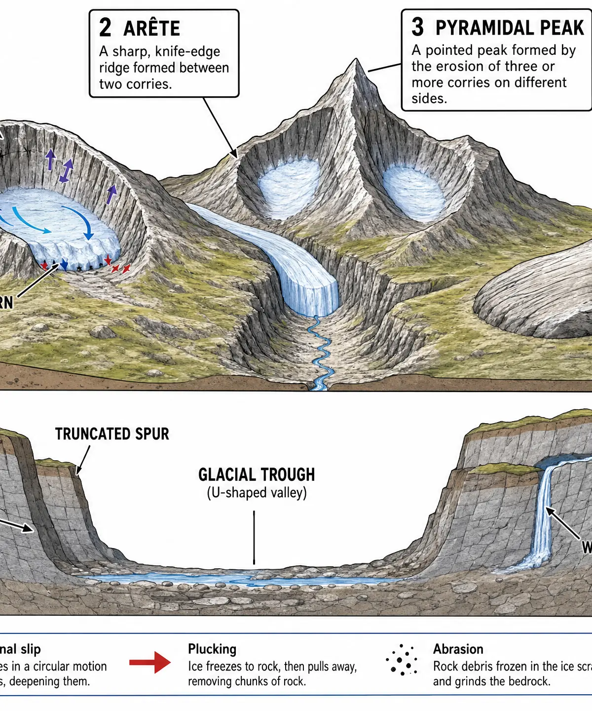
Corrie (Cwm / Cirque)
What it is: A large, bowl-shaped hollow found high on a mountainside, often containing a small circular lake called a tarn.
Formation:
- Snow accumulates in a small hollow on a north or north-east facing slope (where it is shaded from the sun).
- Over time, the snow compresses into firn and then solid glacial ice.
- The ice moves downhill in a circular motion called rotational slip, eroding the hollow.
- Plucking steepens the back wall, while freeze-thaw weathering above the glacier shatters the rock, making it jagged.
- Abrasion deepens the floor of the hollow.
- As the glacier moves out of the hollow, it leaves a rock lip at the front.
- When the ice melts, a deep, steep-sided bowl remains. If water collects in the bottom, a tarn is formed.
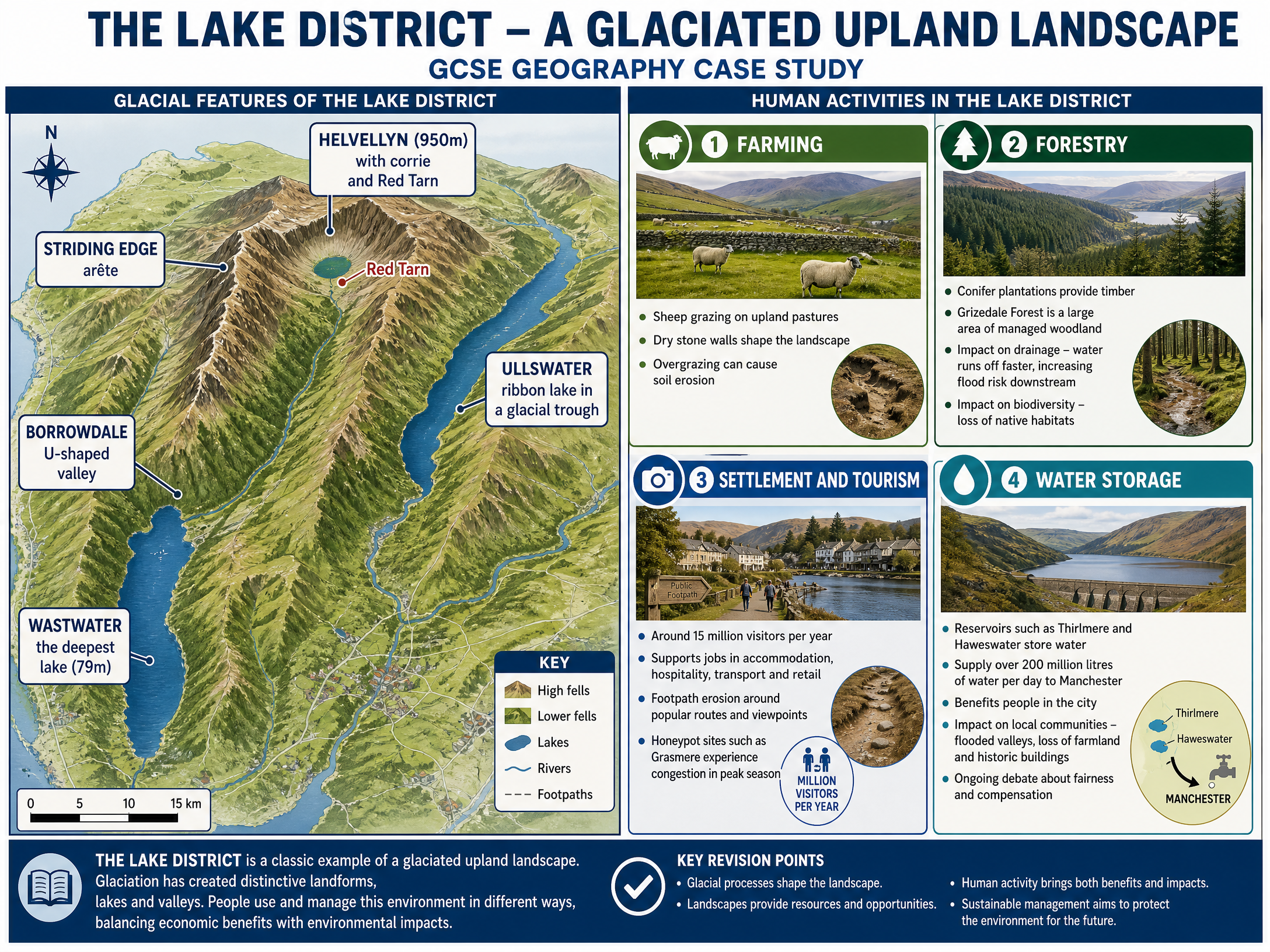
Named Example: Red Tarn on Helvellyn in the Lake District.
Arête and Pyramidal Peak
Arête: A sharp, knife-edge ridge formed when two corries erode back-to-back towards each other. The back walls of the corries are eroded by plucking and freeze-thaw weathering until only a narrow ridge remains between them.
Named Example: Striding Edge on Helvellyn.
Pyramidal Peak: A sharp, pointed mountain summit formed when three or more corries erode back towards the same mountain peak from different sides.
Named Example: The Matterhorn in the Alps (or Snowdon in Wales).
Glacial Trough (U-Shaped Valley)
What it is: A wide, deep valley with steep, near-vertical sides and a wide, flat floor.
Formation:
- Before glaciation, rivers carved interlocking V-shaped valleys.
- During the Ice Age, a large, powerful glacier moves down the existing river valley.
- The glacier's immense weight and power widen and deepen the valley through severe abrasion and plucking.
- The glacier cuts straight through the river's interlocking spurs, leaving blunt cliff faces called truncated spurs.
- When the ice melts, a U-shaped valley is left behind. Sometimes a long, narrow lake called a ribbon lake forms in the over-deepened valley floor.
Named Example: Borrowdale (U-shaped valley) and Ullswater (ribbon lake) in the Lake District.
Hanging Valley
What it is: A smaller tributary valley that is left 'hanging' high above the floor of the main glacial trough.
Formation:
Smaller tributary glaciers join the main glacier. Because they are smaller, they have less erosive power and cannot cut down as deeply as the massive main glacier. When the ice melts, the tributary valley floor is left much higher than the main valley floor. Rivers flowing down the hanging valley often form spectacular waterfalls as they plunge into the main trough.
Distinctive Depositional Landforms
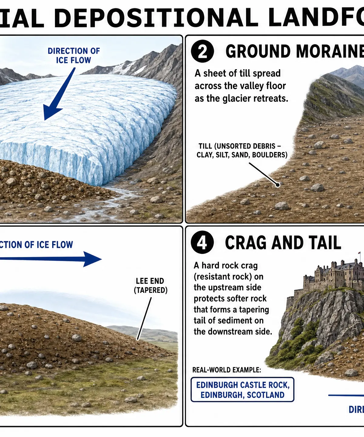
Moraines
Moraines are landforms made of till (unsorted glacial debris).
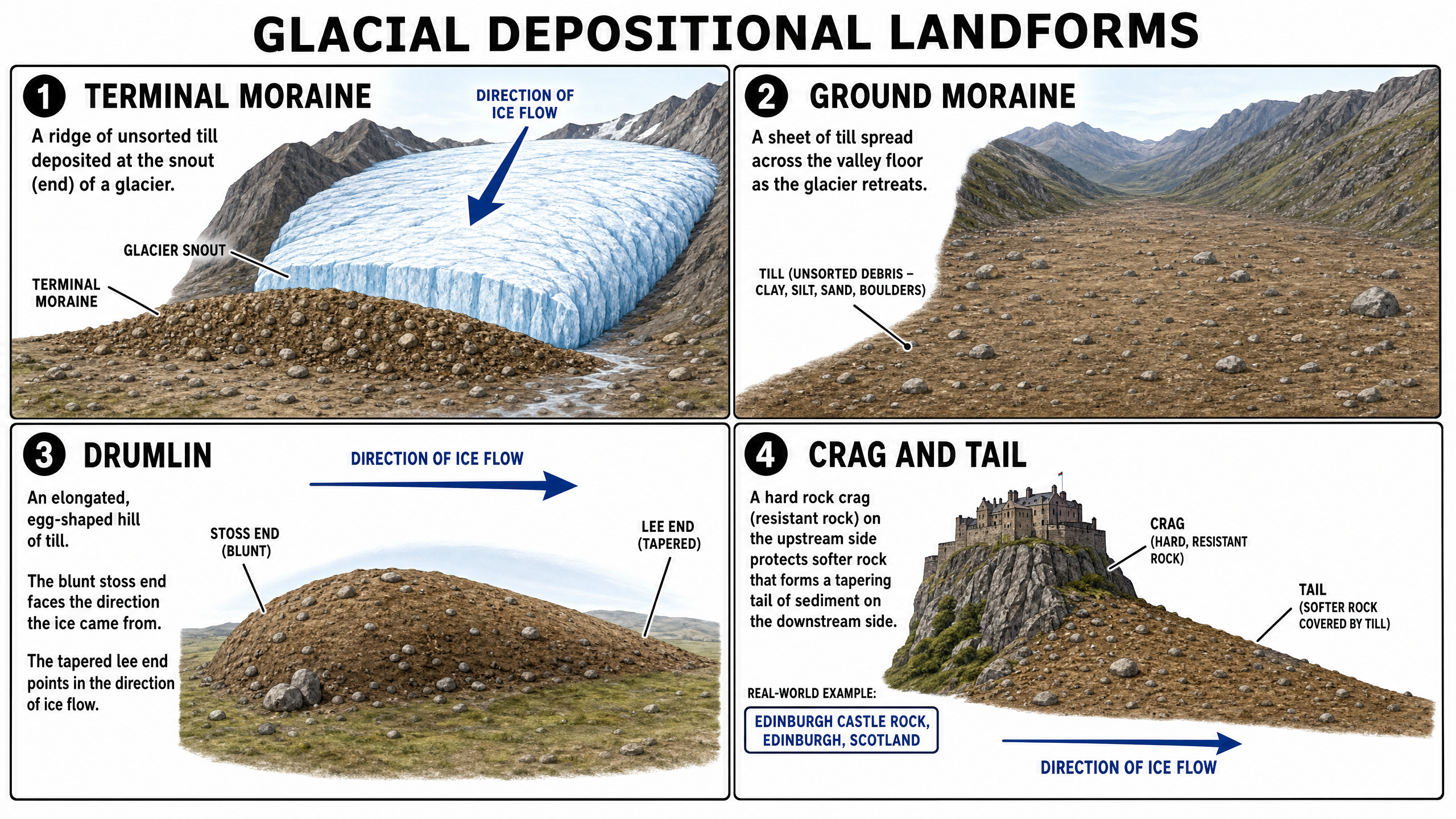
Terminal Moraine: A high ridge of till deposited at the snout (front end) of the glacier. It marks the maximum advance (the furthest point) the glacier reached. As the ice melts at the snout, it continually drops material, building up a ridge across the valley.
Ground Moraine: A sheet of till spread unevenly across the valley floor as the glacier gradually retreats (melts backwards). It creates a hummocky, uneven landscape.
Lateral Moraine: A ridge of till running along the edge (sides) of a glacial valley. Material from freeze-thaw weathering falls onto the edges of the glacier and is carried along, then deposited when the ice melts.
Medial Moraine: Formed when two glaciers merge. The two inner lateral moraines join together to form a single line of debris running down the middle of the new, larger glacier.
Drumlins
What they are: Elongated, egg-shaped hills made of glacial till. They can be up to 50m high and over 1km long, often occurring in groups or 'swarms' (sometimes called 'basket of eggs' topography).
Formation:
They are formed when a glacier becomes overloaded with sediment and deposits it. The glacier then continues to move over the deposited till, moulding and smoothing it into a streamlined shape.
- The stoss end (blunt, steeper end) faces the direction the ice came from.
- The lee end (tapered, gentle slope) points in the direction the ice was moving.
Drumlins are excellent indicators of the direction of past ice flow.
Crag and Tail (Erosional & Depositional)
What it is: A landform consisting of a hard rock crag with a tapering tail of softer rock and till behind it.
Formation:
A glacier encounters a very hard, resistant rock outcrop (the crag). The ice is forced over and around the crag. The crag protects the softer rock on its downstream (lee) side from erosion. The softer rock remains as a tapering 'tail', which is often further coated in deposited till.
Named Example: Edinburgh Castle Rock (the crag) and the Royal Mile (the tail).
Human Activity in Glaciated Upland Landscapes
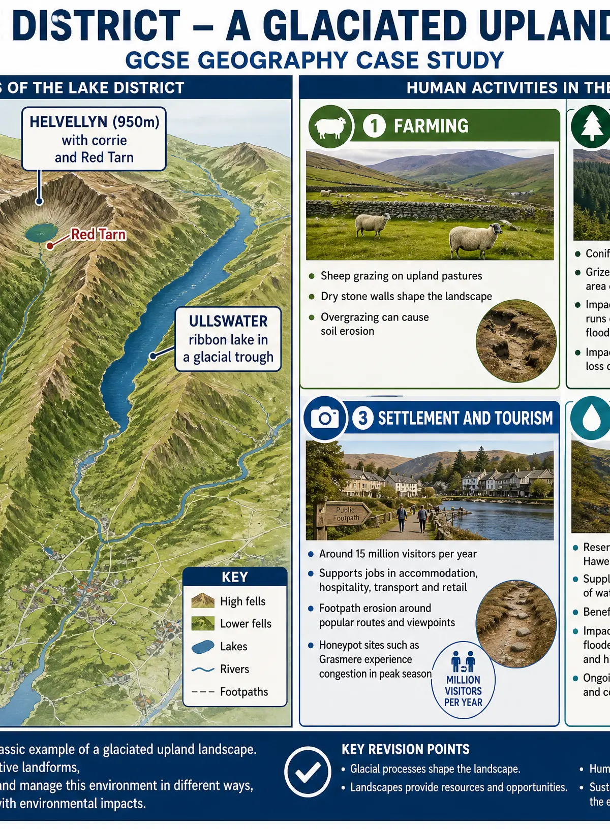
Glaciated upland areas, like the Lake District, are challenging environments (steep slopes, thin soils, cold/wet climate) but they offer significant opportunities for human activity. Examiners expect you to understand the conflicts between development and conservation.
Farming
- Activity: Mostly extensive sheep farming on the steep upland fells (e.g., Herdwick sheep in the Lake District), as the steep slopes and thin soils make arable (crop) farming impossible. Lower valley floors are used for cattle or hay meadows.
- Impacts: Sheep grazing maintains the iconic bare, treeless landscape. However, overgrazing can lead to the removal of vegetation, causing severe soil erosion.
Forestry
- Activity: Planting of large coniferous forests (e.g., pine, spruce) on steep valley sides because they can tolerate the poor soils and harsh climate.
- Impacts: Provides timber and rural jobs. However, dense conifer plantations reduce biodiversity (they block out light, preventing undergrowth) and can look unnatural, upsetting tourists. Harvesting trees with heavy machinery can cause soil erosion and increase surface runoff, leading to flooding downstream.
Settlement and Tourism
- Activity: Glaciated landscapes are spectacular and attract millions of visitors (the Lake District receives around 15 million visitors annually). Tourists come for walking, climbing, boating, and enjoying the scenery.
- Impacts (Positive): Major source of income and employment for locals (hotels, cafes, outdoor gear shops).
- Impacts (Negative):
- Footpath erosion: Millions of boots wear away vegetation, exposing soil which is then washed away by heavy rain, leaving deep scars on the landscape.
- Traffic congestion: Narrow country roads become blocked, causing air pollution and frustrating locals.
- Honeypot sites: Popular villages (like Grasmere or Bowness) become overcrowded, losing their character.
- Second homes: Wealthy buyers purchase holiday homes, driving up house prices so local young people can no longer afford to live there.
Water Storage and Supply
- Activity: Glaciated valleys are perfect for reservoirs. They are deep, narrow, have high rainfall, and impermeable rock. Ribbon lakes are often dammed to increase their capacity.
- Impacts: Provides clean, reliable water and renewable hydroelectric power (HEP) to distant cities (e.g., Thirlmere and Haweswater supply Manchester). However, creating reservoirs involves flooding valleys, which destroys habitats, drowns good agricultural land on the valley floor, and sometimes forces the relocation of entire communities (e.g., the village of Mardale was flooded to create Haweswater).
Visual Resources
3 diagrams and illustrations
Interactive Diagrams
1 interactive diagram to visualise key concepts
Conceptual Flow Outline
Step-by-step formation of a Corrie
Worked Examples
3 worked examples — open one to explore the question and available guidance.
Practice Questions
Test your understanding — click to reveal model answers
Explain the formation of a glacial trough (U-shaped valley). (6 marks)
Hint: Start with what the valley looked like before the glacier arrived, then explain the specific erosional processes.
Explain how physical and human processes interact in a named glaciated upland landscape. (6 marks)
Hint: Think about how the physical shape of the land dictates what humans can do there (e.g., steep slopes = sheep farming).
State two characteristics of glacial till. (2 marks)
Hint: Think about the size and arrangement of the rocks dropped by melting ice.
Using an example, explain how a drumlin can indicate the direction of past ice movement. (3 marks)
Hint: Describe the shape of the two ends of the drumlin.
Evaluate the statement: 'The economic benefits of tourism in glaciated areas outweigh the environmental costs.' (9 marks)
Hint: Provide arguments for both sides, use your case study, and make a final judgement.