Pearson Edexcel · GCSE · Geography
Human activities can lead to changes in river landscapes which affect people and the environment
Discover how our choices shape the flow of water across the landscape. This crucial GCSE Geography topic connects human activities like urbanisation and agriculture with the physical processes of river flooding, equipping you with the knowledge to evaluate real-world engineering solutions.
- 8 min read
- 3 worked examples
- 2 practice questions
- 6 key terms
Study Notes
Overview
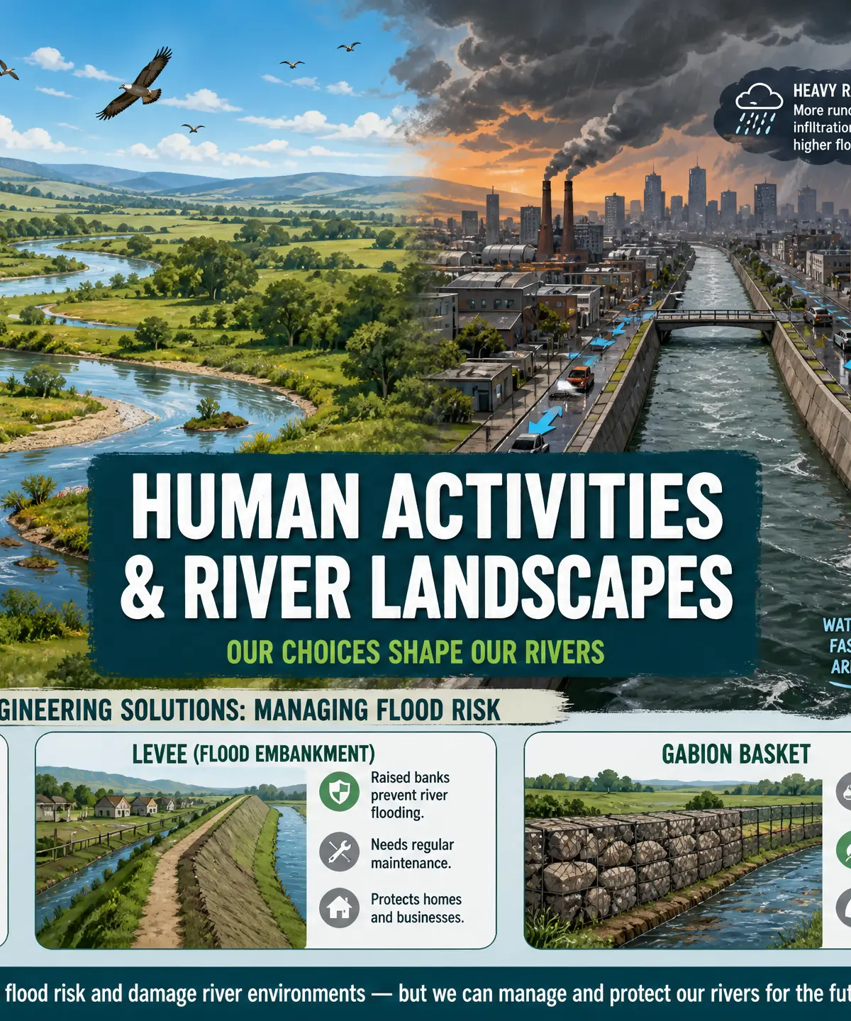
This study guide covers the critical intersection of physical and human geography: how human activities alter river landscapes and influence flood risk. For GCSE Geography candidates, this is a high-yield topic where examiners consistently test your ability to link human actions (like urbanisation, agriculture, and industry) directly to changes in river processes (such as surface runoff, lag time, and peak discharge).
You will need to master the distinction between the physical and human causes of flooding, and evaluate the advantages and disadvantages of both hard and soft engineering strategies. Examiners highly reward the use of precise geographical terminology and specific, named case studies to support your arguments. This guide provides the structure, examples, and techniques you need to achieve top marks.
Key Human Activities Affecting Rivers
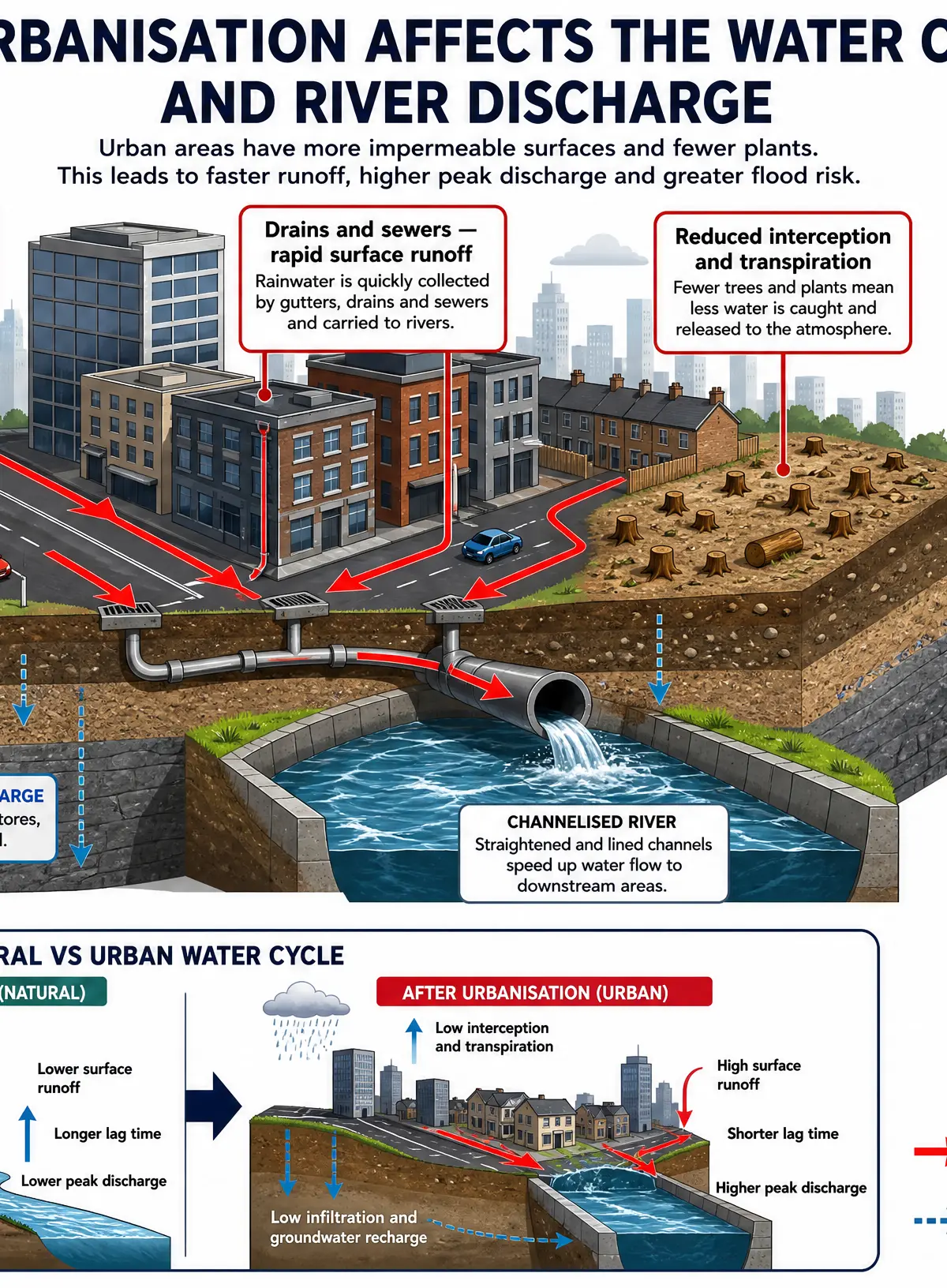
Urbanisation
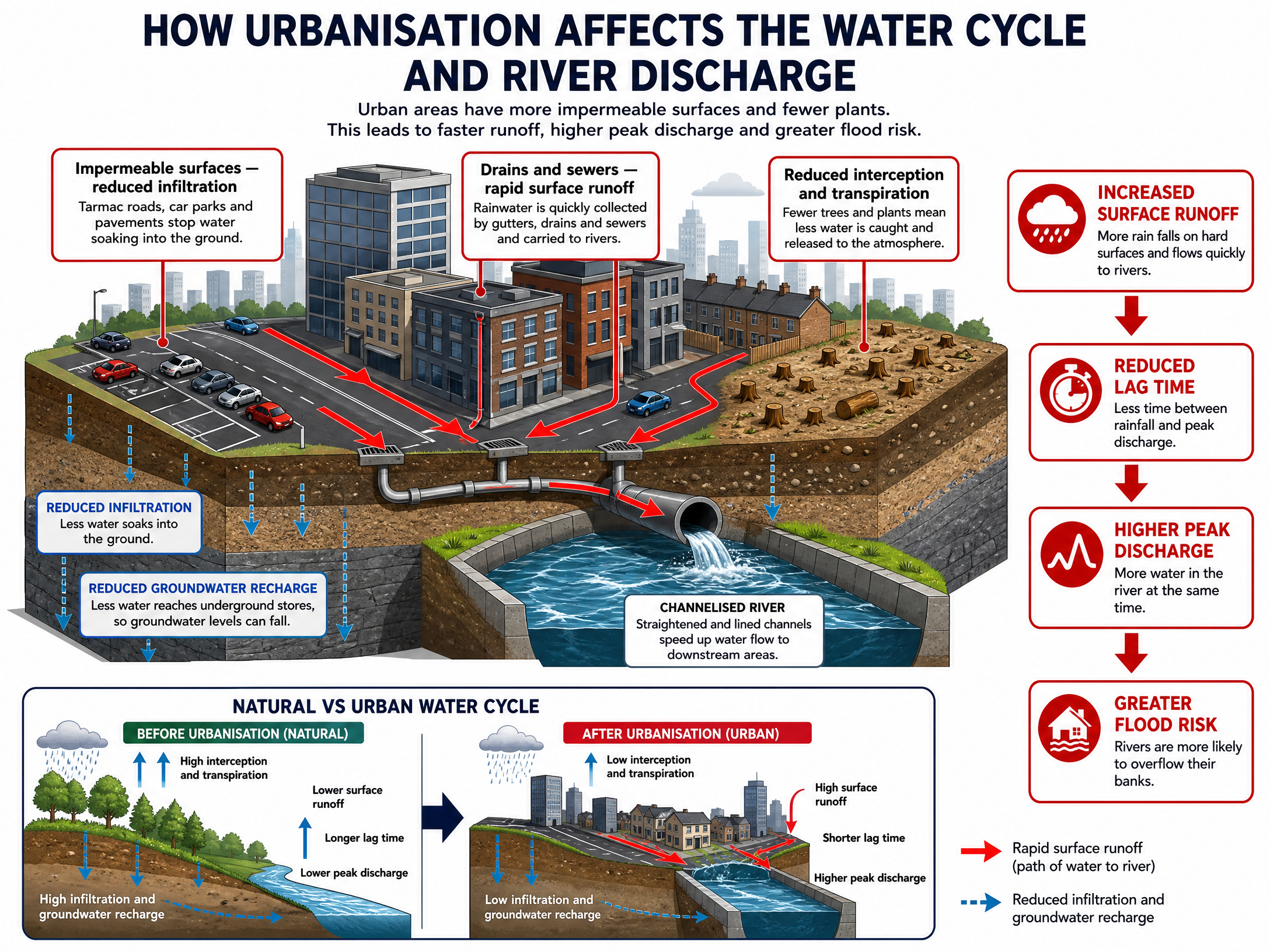
The Process: The expansion of towns and cities replaces natural, permeable ground (like soil and vegetation) with impermeable surfaces (like tarmac roads, concrete pavements, and rooftops).
Impact on River Processes:
- Reduced Infiltration: Water cannot soak into the ground.
- Increased Surface Runoff: Rainwater flows rapidly over the surface.
- Drains and Sewers: Artificial drainage systems channel water extremely quickly into rivers.
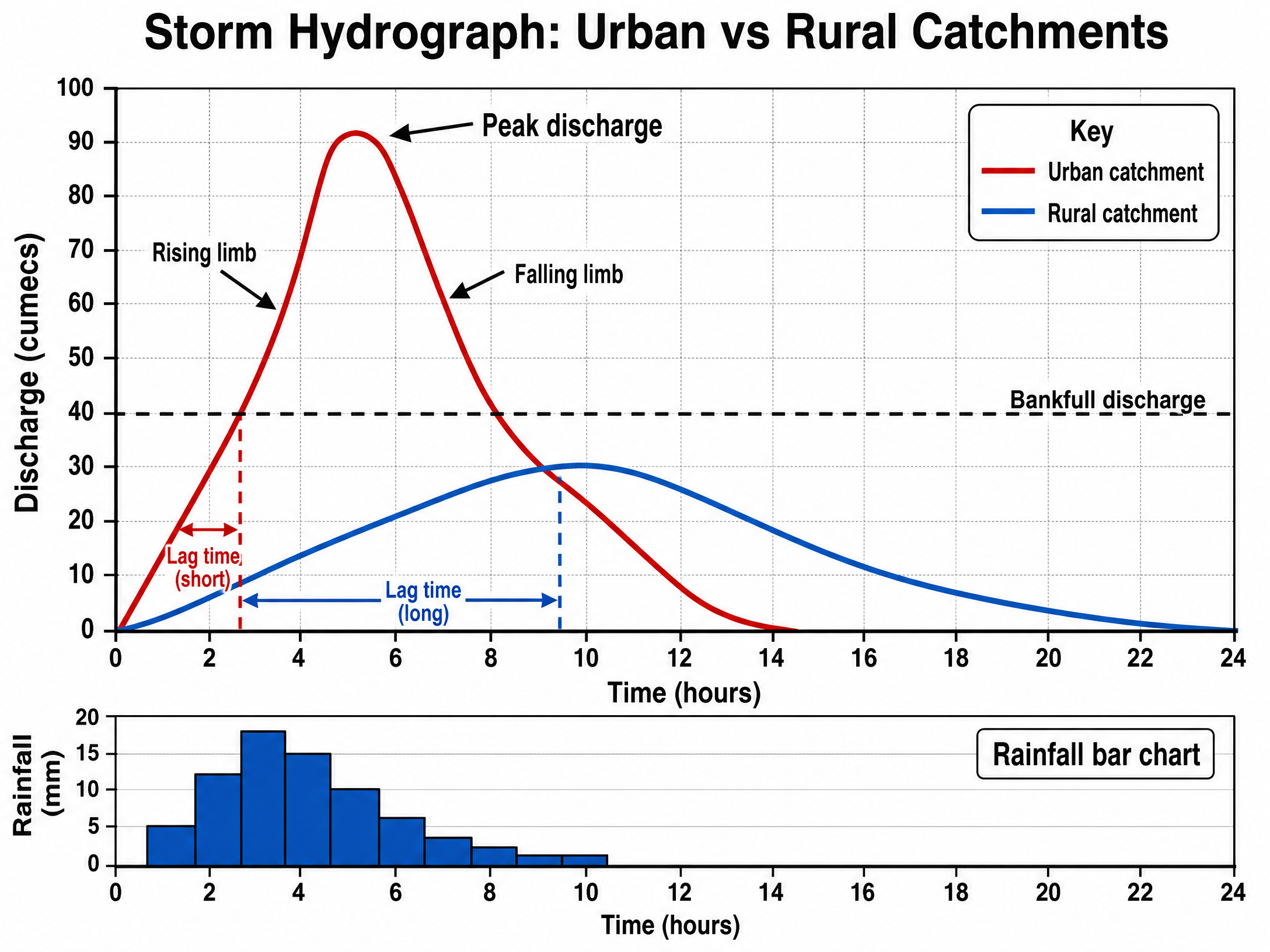
Exam Focus: Urbanisation leads to a shorter lag time and a higher peak discharge on a storm hydrograph, significantly increasing the risk of flooding.
Agriculture
The Process: Farming practices alter the natural landscape to produce food. This includes removing hedgerows, ploughing fields, and grazing livestock.
Impact on River Processes:
- Reduced Interception: Removing trees and hedgerows means less rainfall is caught before hitting the ground.
- Soil Compaction: Heavy machinery and overgrazing by animals compress the soil, reducing its permeability and infiltration capacity.
- Increased Runoff and Erosion: Water flows faster over compacted soil, washing topsoil into rivers. This increases the river's load and can cause sedimentation, raising the riverbed and reducing channel capacity.
Industry
The Process: The development of factories, warehouses, and industrial estates.
Impact on River Processes:
- Similar to urbanisation, industry creates large areas of impermeable surfaces, increasing surface runoff.
- Industrial processes may also abstract (remove) water from rivers or discharge warm/polluted water back into them, affecting both water quantity and quality.
River Flooding: Causes and Effects
Physical Causes of Flooding
Examiners expect you to distinguish physical causes from human causes. Key physical causes include:
- Prolonged Heavy Rainfall: Saturates the soil, meaning no more infiltration can occur (the ground reaches field capacity).
- Geology: Impermeable rocks (like clay or granite) prevent water from soaking in.
- Relief (Topography): Steep valley sides cause water to flow rapidly down to the river channel.
- Snowmelt: Rapid melting of snow in spring releases large volumes of water quickly.
Effects of Flooding
On People (Social & Economic):
- Destruction of homes and personal property.
- Disruption to transport networks (roads and bridges closed).
- Loss of income for businesses and farmers (crops destroyed).
- Psychological distress and cost of insurance/repairs.
- Case Study Example: The 2015 floods in Cumbria (Storm Desmond) caused over £500 million in damage and flooded over 5,000 homes.
On the Environment:
- Negative: Floodwaters can wash pollutants (sewage, agricultural chemicals, industrial waste) into rivers and surrounding habitats.
- Positive: Flooding deposits nutrient-rich alluvium (silt) onto the floodplain, creating highly fertile agricultural land (e.g., the Nile Delta).
Managing Flood Risk: Engineering Strategies
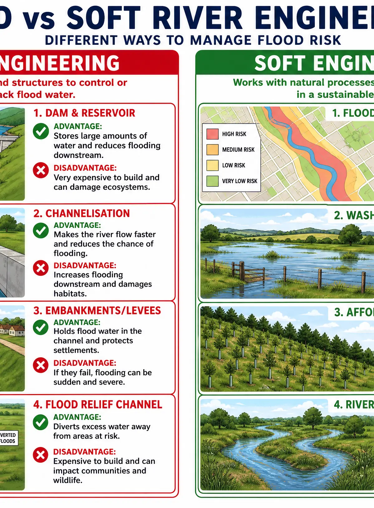
Hard Engineering
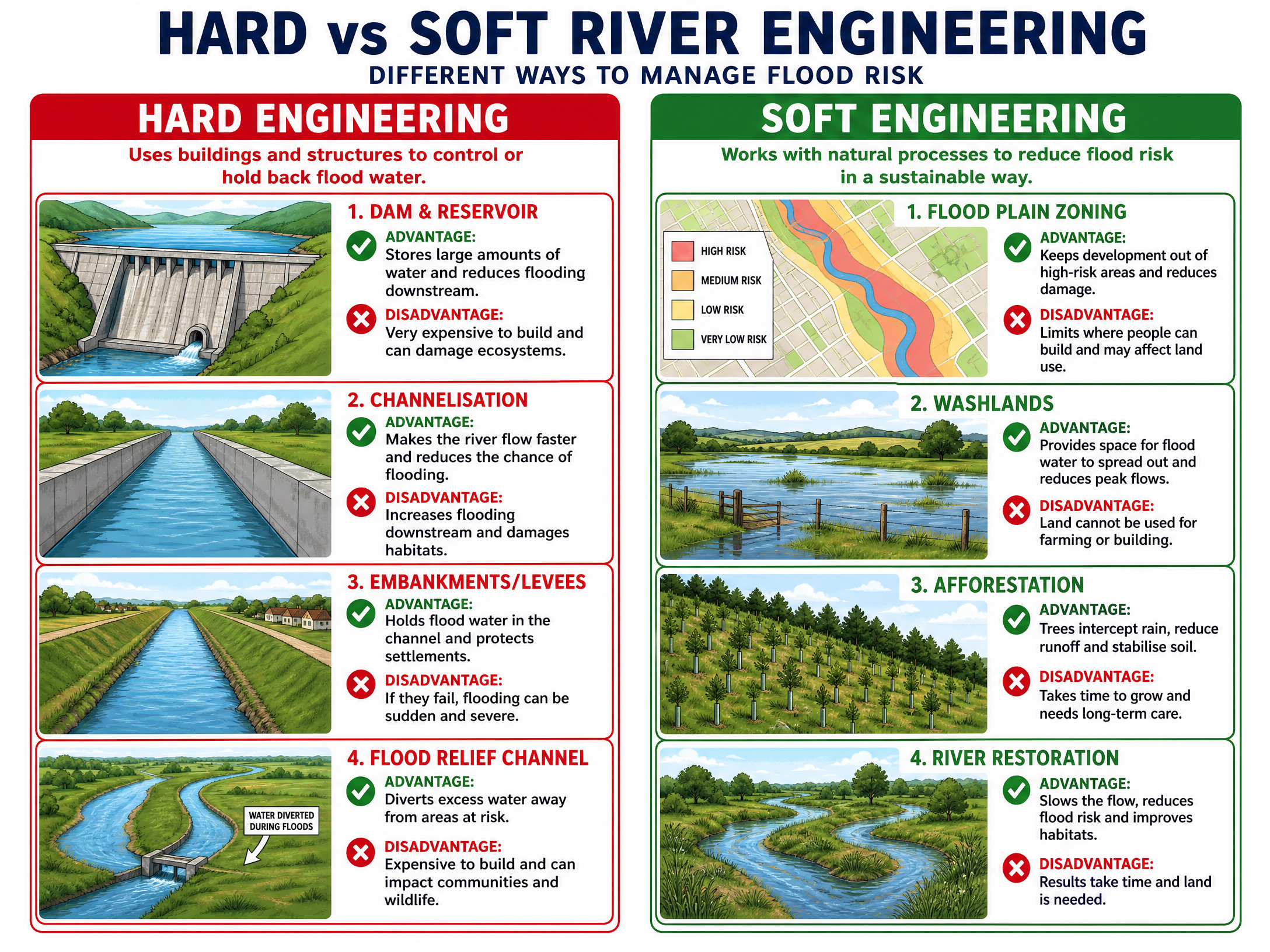
Hard engineering involves building artificial structures to control river flow. These are often expensive and have significant environmental impacts.
-
Dams and Reservoirs
- What it is: A large concrete barrier built across a river to impede its flow, creating an artificial lake (reservoir) behind it.
- Advantage: Highly effective at regulating water flow; stores water which can be used for drinking or generating hydroelectric power (HEP).
- Disadvantage: Extremely expensive to build; floods large areas of land behind the dam, destroying habitats and displacing communities (e.g., Three Gorges Dam, China).
-
Channelisation (Straightening and Deepening)
- What it is: Artificially modifying the river channel, often lining it with concrete, to make it straighter, wider, or deeper.
- Advantage: Increases the capacity of the channel and speeds up the flow of water away from vulnerable areas.
- Disadvantage: Looks unnatural and destroys river habitats; simply transfers the flood risk faster to areas further downstream.
-
Embankments (Levees)
- What it is: Artificially raised banks built alongside the river.
- Advantage: Increases the cross-sectional area of the river, allowing it to hold more water before flooding.
- Disadvantage: If the embankment breaches or is overtopped, the resulting flood can be sudden, deep, and catastrophic.
-
Flood Relief Channels
- What it is: Artificial channels built to bypass urban areas, diverting excess water during times of high flow.
- Advantage: Protects high-value urban areas effectively (e.g., the Jubilee River protecting Maidenhead and Windsor).
- Disadvantage: Expensive to construct and requires a large amount of land.
Soft Engineering
Soft engineering works with natural river processes to manage flood risk in a more sustainable way.
-
Flood Plain Zoning
- What it is: Local authorities restrict certain types of development in areas at high risk of flooding. High-risk areas are used for playing fields or grazing; housing and hospitals are built on higher ground.
- Advantage: Very cheap; reduces the economic and social impact of flooding because vulnerable buildings are kept out of harm's way.
- Disadvantage: Does not actually stop flooding from happening; difficult to implement in already heavily urbanised areas.
-
Afforestation (Planting Trees)
- What it is: Planting trees in the upper course of the river catchment.
- Advantage: Trees increase interception and root uptake, reducing surface runoff and increasing lag time. It also creates wildlife habitats and absorbs CO2.
- Disadvantage: Takes many years for trees to grow and become effective; requires large areas of land that could be used for farming.
-
River Restoration
- What it is: Removing hard engineering structures (like concrete channels) and allowing the river to return to its natural, meandering course.
- Advantage: Recreates natural wetlands and habitats, increasing biodiversity; a meandering river slows water flow naturally.
- Disadvantage: Can result in the loss of agricultural land adjacent to the river; may not provide enough protection for major urban areas.
Storm Hydrographs
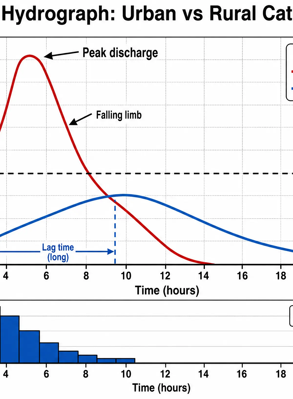
Storm hydrographs show how a river's discharge responds to a period of rainfall. Examiners frequently ask you to interpret these graphs.
- Urban Catchments: Produce a 'flashy' hydrograph. The rising limb is steep, the peak discharge is high, and the lag time is short due to rapid surface runoff over impermeable surfaces.
- Rural/Forested Catchments: Produce a 'subdued' hydrograph. The rising limb is gentle, peak discharge is lower, and lag time is longer because water infiltrates the soil and moves slowly as throughflow or groundwater flow.
Audio Revision: Podcast Episode
Listen to our comprehensive 10-minute revision podcast covering all these topics, complete with exam tips and a quick-fire quiz.

Visual Resources
3 diagrams and illustrations
Interactive Diagrams
1 interactive diagram to visualise key concepts
Conceptual Flow Outline
Flowchart showing how land use affects flood risk
Worked Examples
3 worked examples — open one to explore the question and available guidance.
Practice Questions
Test your understanding — click to reveal model answers
Explain how agriculture can increase the risk of river flooding. (4 marks)
Hint: Think about what farmers do to the land (trees, soil, animals) and how that affects where the water goes.
Evaluate the use of soft engineering strategies in managing river landscapes. (9 marks)
Hint: You need to discuss both the positives and negatives of soft engineering, using specific examples like flood plain zoning or afforestation, and reach a conclusion.