Pearson Edexcel · GCSE · Geography
The context of the chosen UK city influences its functions and structure
This study guide explores how the site, situation, and connectivity of a UK city shape its internal structure and functions. Understanding these foundational concepts is crucial for explaining why cities like Manchester or Birmingham look and operate the way they do today, a key requirement for securing top marks in GCSE Geography.
- 5 min read
- 3 worked examples
- 5 practice questions
- 6 key terms
Study Notes
Overview
This topic examines the fundamental reasons why major UK cities exist where they do, and how those origins continue to influence their modern structure. Examiners expect candidates to move beyond generic descriptions of urban zones and instead make analytical links between a city's geographical context (site, situation, and connectivity) and its specific functions. Using a named case study—such as Manchester, Birmingham, or Leeds—is essential. You must be able to describe the characteristics of the Central Business District (CBD), inner city, suburbs, and urban-rural fringe, while explaining how building age, land use, and environmental quality vary across these zones.
Geographical Context
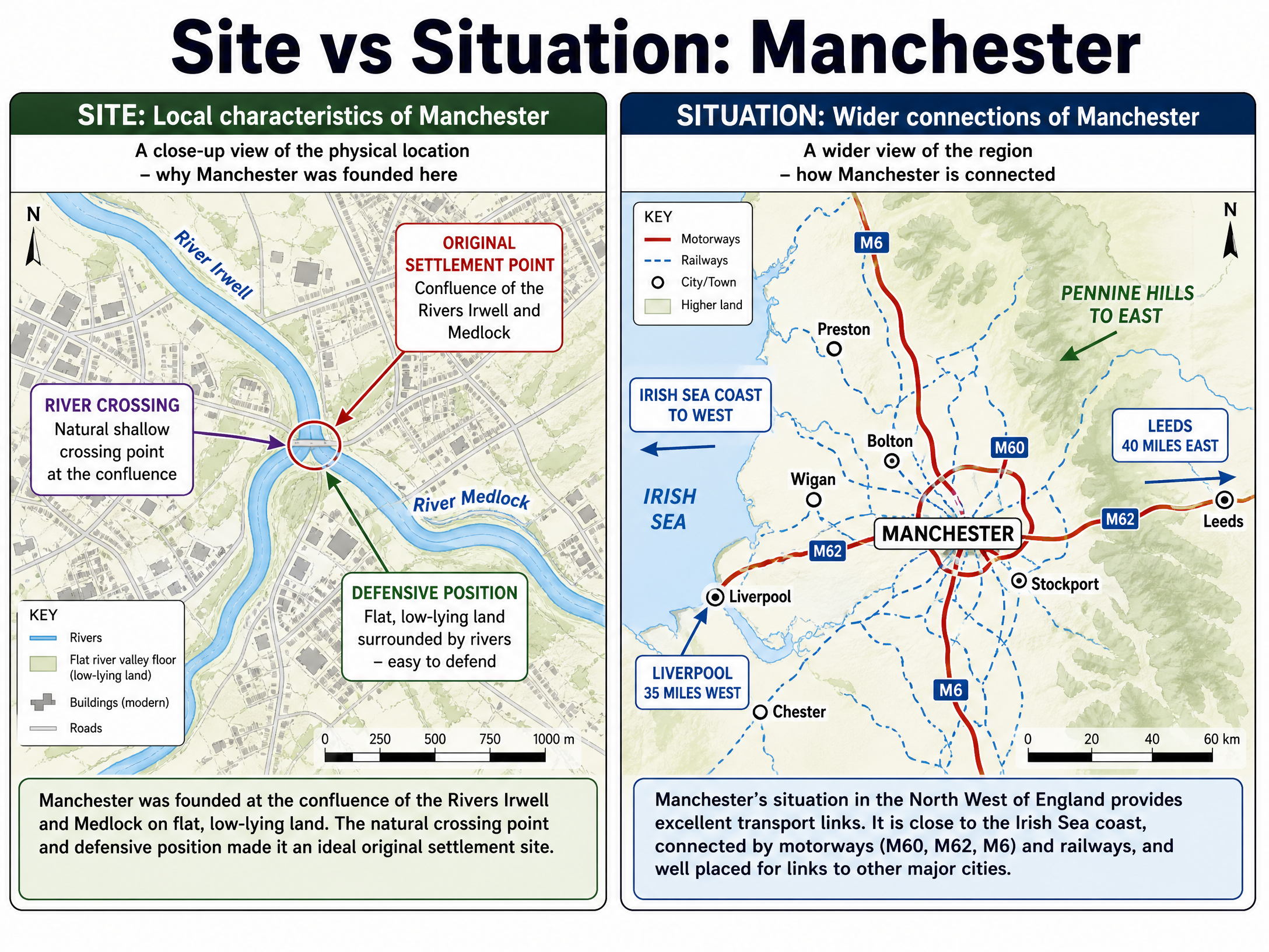
Site
Definition: The actual physical land on which a settlement is built.
Key Factors: Early settlers looked for flat land (easy to build on), water supply (rivers for drinking, transport, and power), and defensive positions (hilltops or river meanders).
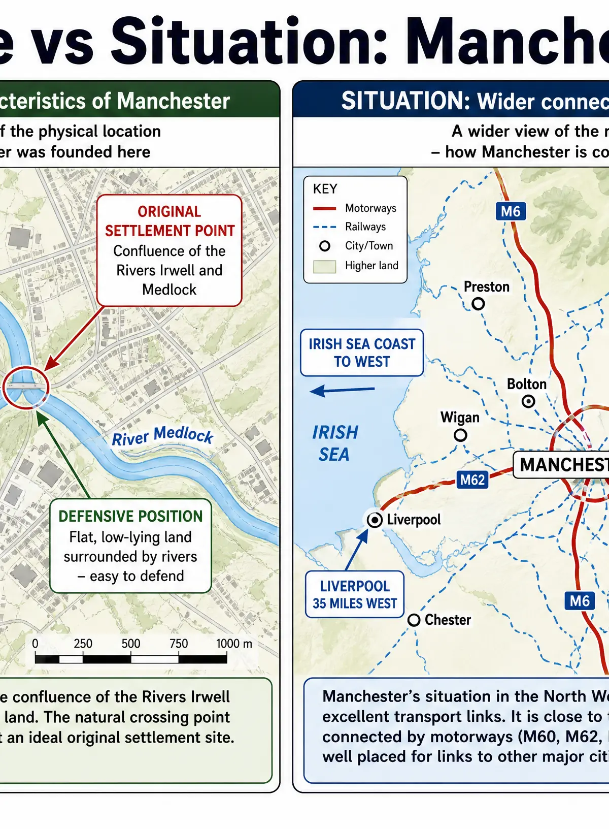
Case Study Example (Manchester): Manchester was originally founded at the confluence of the River Irwell and River Medlock. This provided a natural crossing point, a fresh water supply, and a relatively flat, low-lying river valley floor suitable for early development.
Situation
Definition: The location of a settlement in relation to its surrounding features and other settlements.
Key Factors: Proximity to raw materials, distance to other major cities, and position relative to physical features like hills or coasts.
Case Study Example (Manchester): Situated in the North West of England, Manchester lies in a lowland corridor between the Pennine Hills to the east and the Irish Sea coast to the west. It is centrally located between Liverpool and Leeds, making it a natural regional hub.
Connectivity
Definition: How well a place is linked to other locations locally, nationally, and globally via transport and communication networks.
Key Factors: Road networks (motorways), rail links, airports, and digital infrastructure.
Case Study Example (Manchester): Manchester is highly connected. Nationally, the M60 orbital motorway and M62 link it across the North, while Piccadilly station provides two-hour rail access to London. Globally, Manchester Airport handles over 29 million passengers annually, supporting its function as an international business and cultural centre.
Urban Structure and Zones
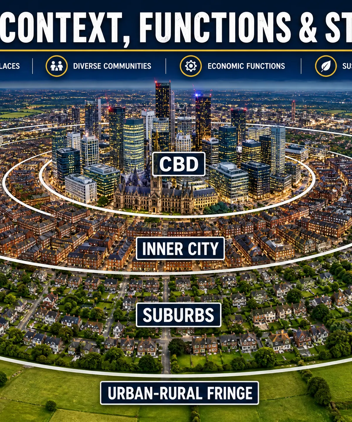
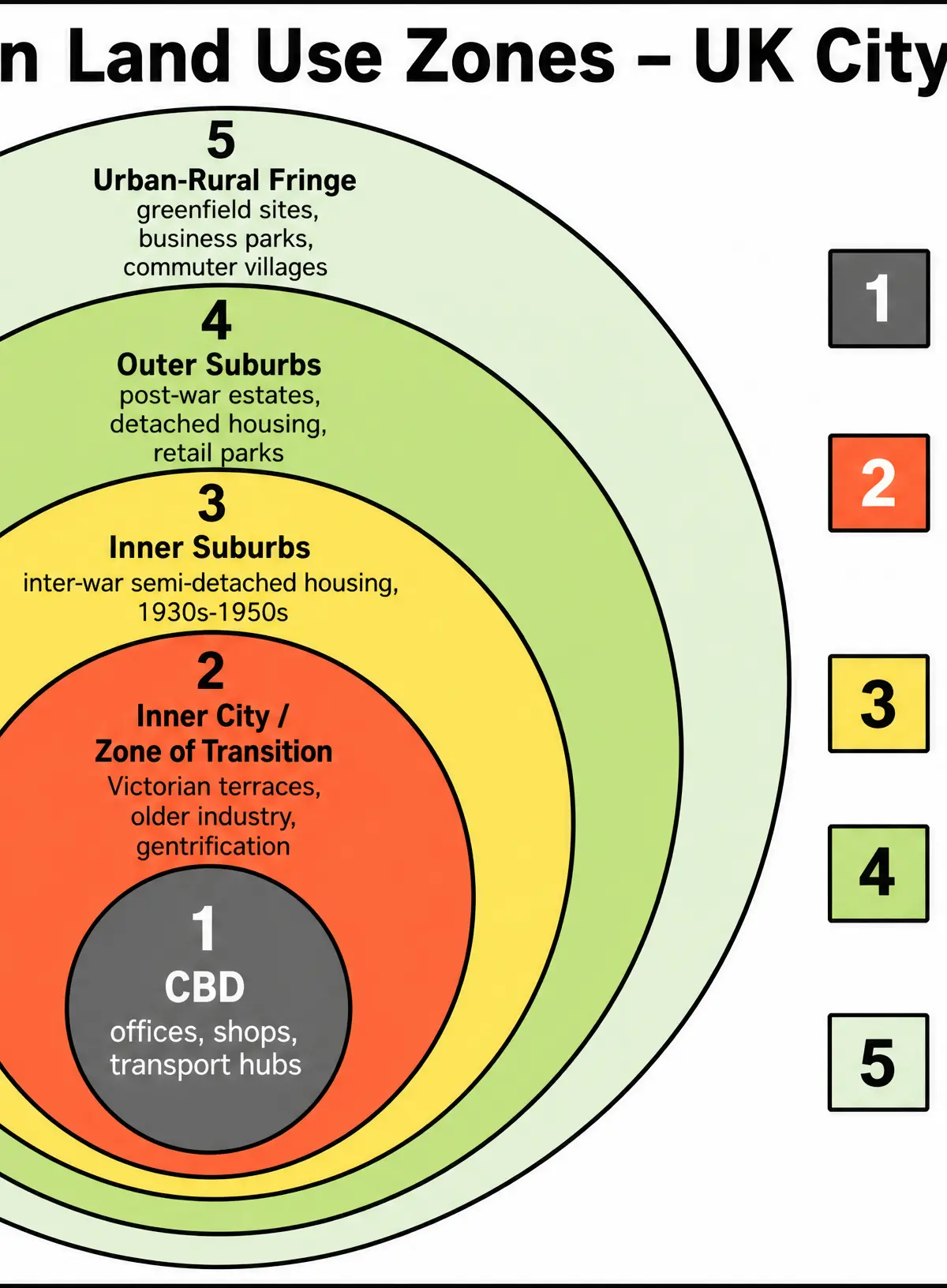
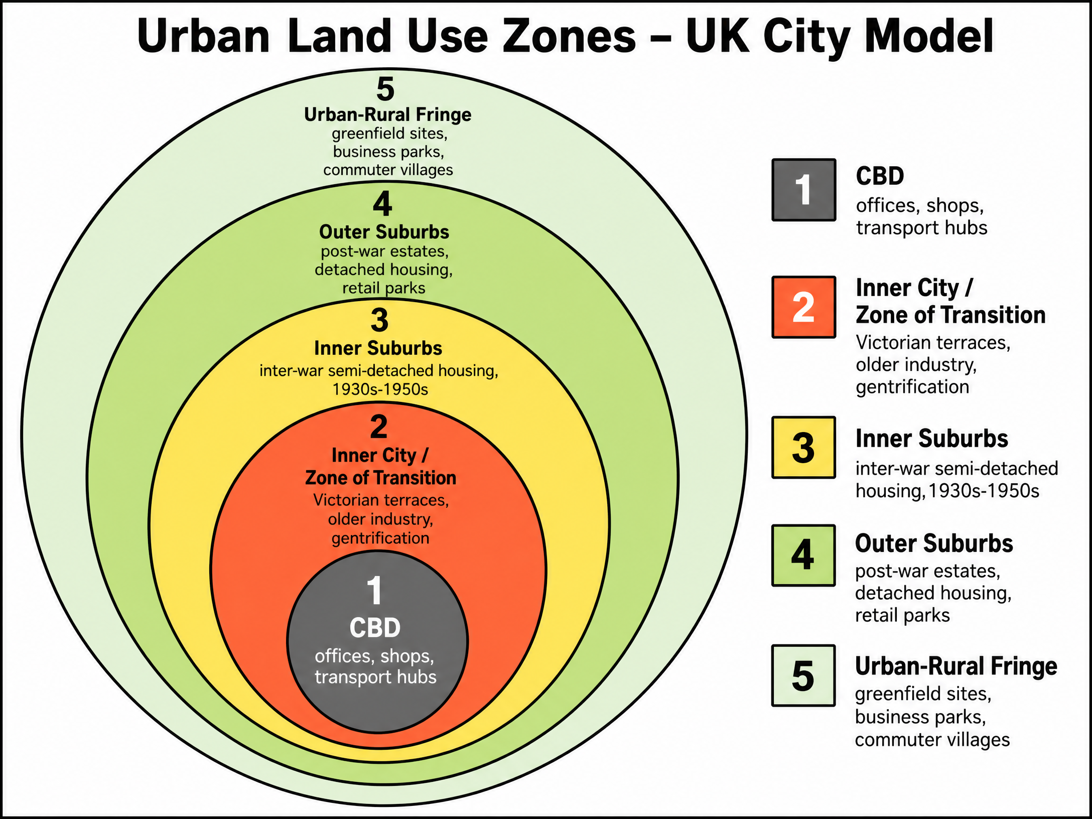
UK cities typically follow a concentric ring model (based on the Burgess Model), with distinct zones radiating outward from the centre.
1. Central Business District (CBD)
Location: The historic centre where major transport routes converge.
Characteristics: Highest land values lead to high-density, tall buildings. A mix of historic civic buildings (town halls) and modern glass-and-steel offices.
Functions: Commercial (retail, finance), administrative, and cultural.
2. Inner City (Zone of Transition)
Location: Immediately surrounding the CBD.
Characteristics: Originally developed during the Industrial Revolution (1750-1900). Characterised by high-density Victorian terraced housing built for factory workers. Today, it is a zone of contrast: some areas suffer from deprivation and older housing stock, while others (like Manchester's Northern Quarter or Ancoats) have undergone extensive gentrification and regeneration.
Functions: Residential, light industry, and increasingly creative/digital hubs.
3. The Suburbs
Location: Radiating outward from the inner city.
Characteristics: Land is cheaper, allowing for lower-density housing with gardens. Inner suburbs often feature 1930s inter-war semi-detached houses. Outer suburbs feature post-1960s detached housing and estates.
Functions: Predominantly residential, with local retail parades, schools, and parks.
4. Urban-Rural Fringe
Location: The very edge of the city where urban development meets the countryside.
Characteristics: A dynamic zone under pressure from urban sprawl. Land is cheaper than the city centre but highly accessible via ring roads.
Functions: Out-of-town retail parks, business/science parks, large housing estates on greenfield sites, airports, and recreational land (golf courses, country parks).
Audio Revision: UK City Context Podcast
Listen to this 10-minute podcast for a comprehensive review of the topic, including an explanation of urban zones, examiner tips, and a quick-fire recall quiz.

Visual Resources
2 diagrams and illustrations
Interactive Diagrams
1 interactive diagram to visualise key concepts
Conceptual Flow Outline
How context influences the city
Worked Examples
3 worked examples — open one to explore the question and available guidance.
Practice Questions
Test your understanding — click to reveal model answers
Explain two ways that the connectivity of a named UK city influences its functions. (4 marks)
Hint: Name a city, identify a transport link, and explain what activity that link allows the city to do.
To what extent has the inner city of your chosen UK city changed in recent years? (9 marks)
Hint: Discuss both what has changed (regeneration/gentrification) and what has stayed the same (historical buildings, pockets of deprivation).
State one characteristic of the Central Business District (CBD). (1 mark)
Hint: Think about building height or land use.
Describe the location of the urban-rural fringe. (2 marks)
Hint: Where is it in relation to the city centre and the countryside?
Explain why out-of-town retail parks are frequently located in the urban-rural fringe. (4 marks)
Hint: Think about land prices and transport access.