Pearson Edexcel · GCSE · Geography
The degree of urbanisation varies across the UK
This topic explores why the UK's 84% urban population is unevenly distributed across different regions. Understanding these variations—and the historical, economic, and physical factors driving them—is essential for mastering the Urban Issues and Challenges section of your GCSE Geography exam.
- 5 min read
- 3 worked examples
- 5 practice questions
- 6 key terms
Study Notes
Overview
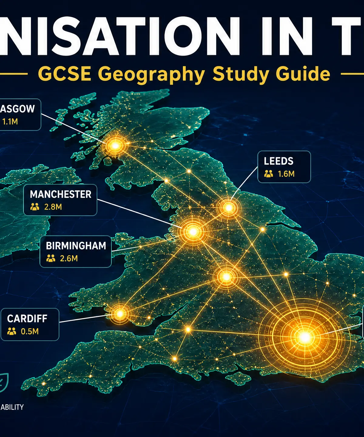
Welcome to your GCSE Geography study guide on UK urbanisation. The United Kingdom is a highly urbanised country, with approximately 84% of its population living in towns and cities. However, this urban population is not evenly distributed. Some regions, like London and the South East, are intensely urbanised, while others, such as Wales and the Scottish Highlands, remain significantly more rural. This study guide explores the distribution of major urban centres and the geographical factors—historical, economic, political, and physical—that cause both the rate and degree of urbanisation to differ across UK regions.
Examiners expect candidates to confidently describe patterns of urban distribution using specific named examples and accurate geographical terminology. Furthermore, you must be able to explain the underlying causes of these patterns, distinguishing clearly between the rate of urbanisation (how fast it is happening) and the degree of urbanisation (the proportion of people already living in urban areas).
Listen to the Podcast

Key Themes & Factors
The Distribution of the UK's Urban Population
Pattern: The UK's urban population is heavily concentrated in England, particularly in the South East and the Midlands, with significant conurbations in the North West and Yorkshire.
Specific Knowledge:
- London: The largest urban centre, dominating the South East with a population of approximately 9 million.
- Major Conurbations: These include Greater Manchester (2.8 million), the West Midlands (centred on Birmingham, 2.6 million), West Yorkshire (centred on Leeds/Bradford, 2 million), and Tyneside (centred on Newcastle, 900,000).
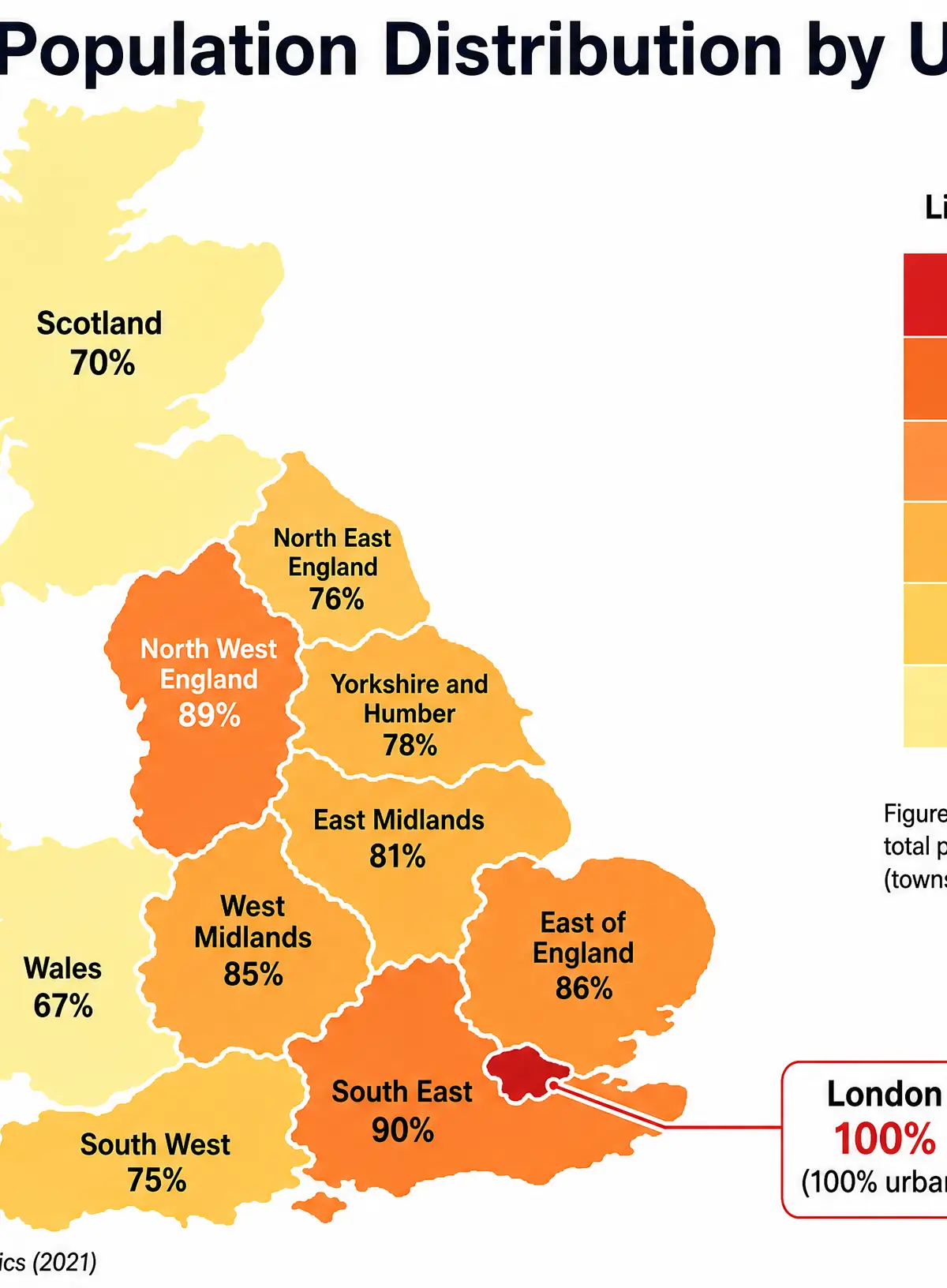
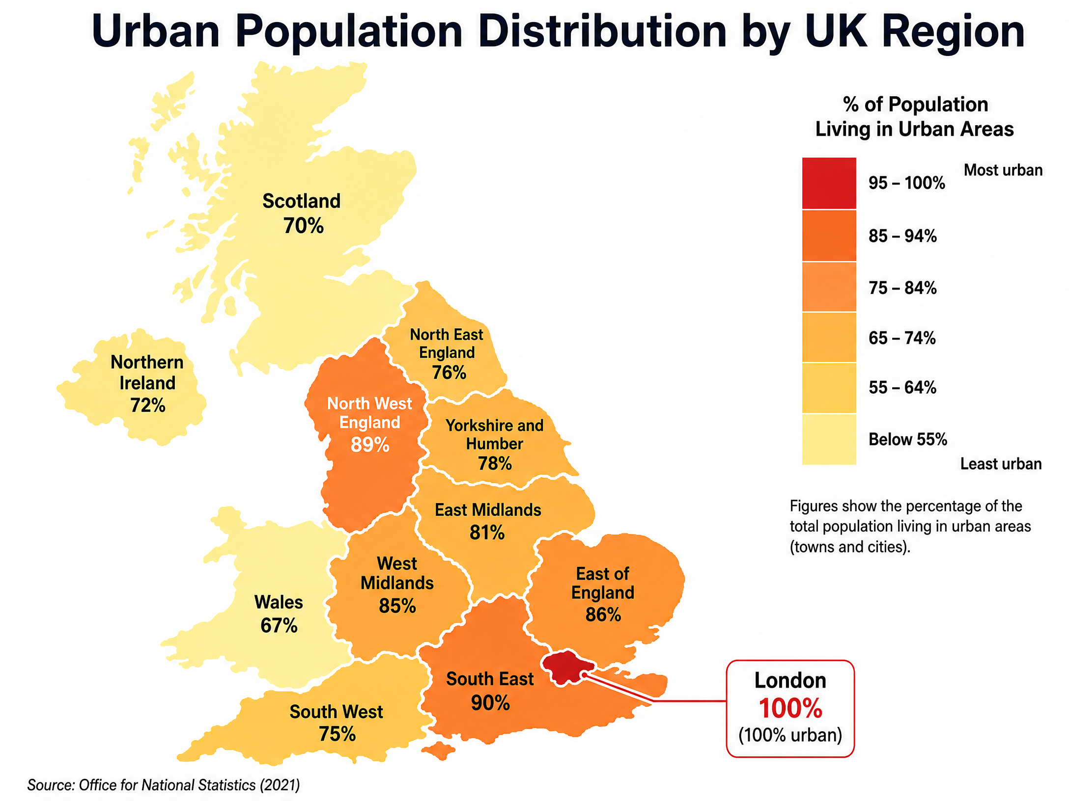
- Regional Variations: England has the highest degree of urbanisation. In contrast, Wales has an urbanisation rate of around 67%, and Scotland is around 70%.
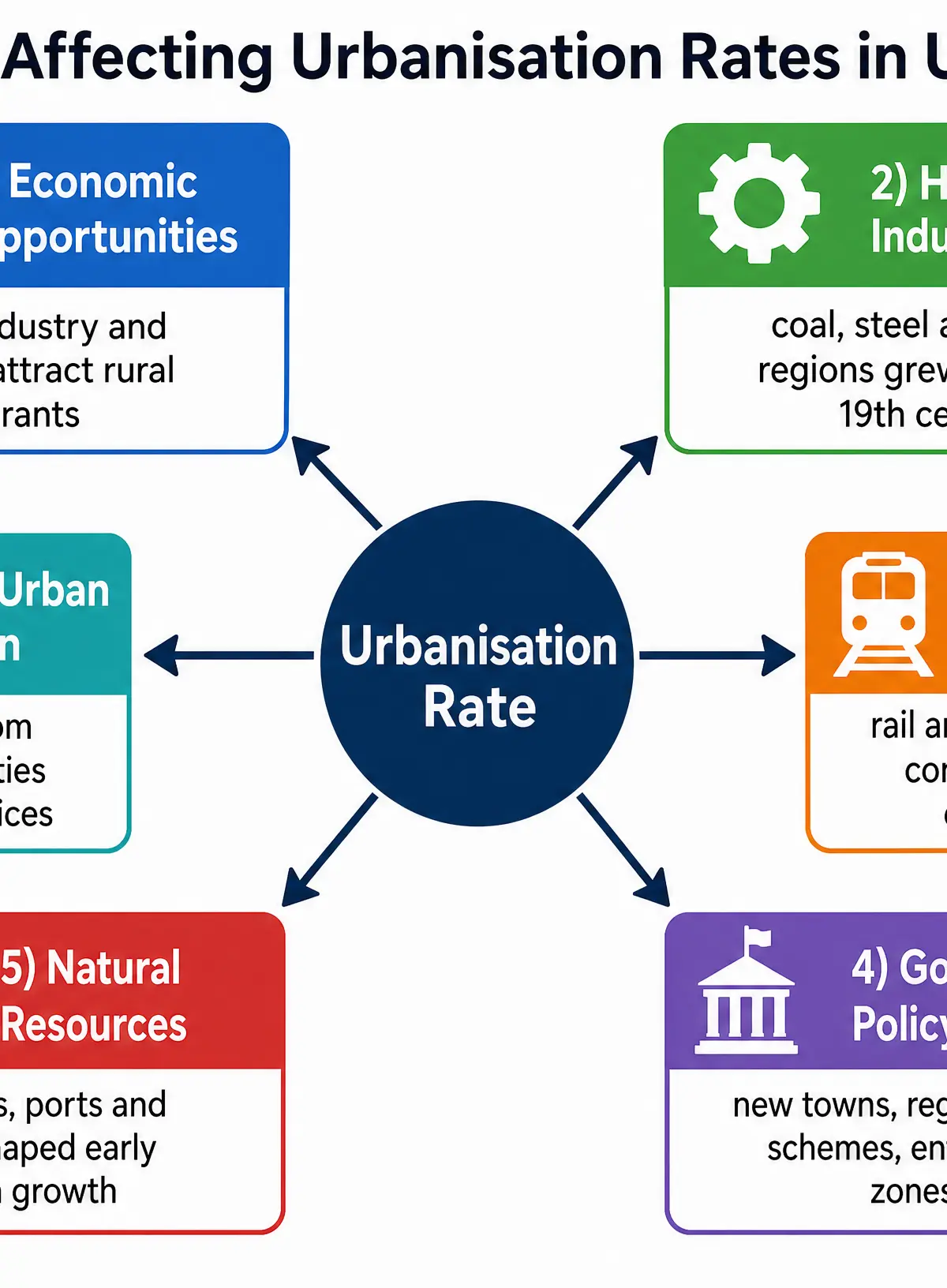
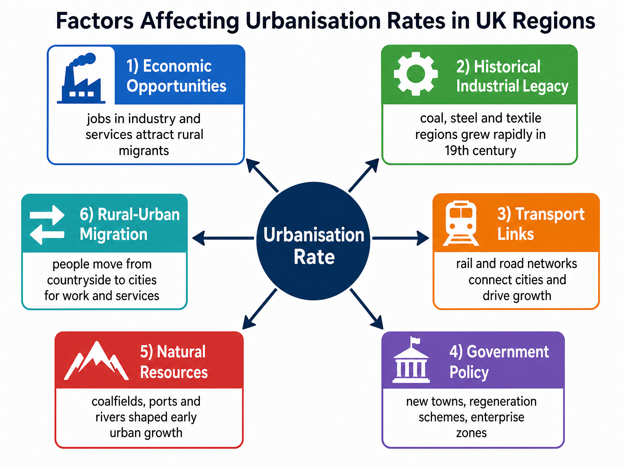
Historical Industrial Legacy
What it is: The profound impact of the 18th and 19th-century Industrial Revolution on settlement patterns.
Why it matters: This is the primary cause of the UK's current urban distribution. Areas with natural resources (especially coal and iron ore) experienced rapid rural-urban migration as people sought work in factories.
Specific Knowledge: The coalfields of South Wales, the West Midlands, South Yorkshire, and the North East attracted massive populations. For example, Manchester grew from around 25,000 people in 1772 to over 300,000 by 1850 due to the cotton textile industry.
Economic Opportunities & Transport Links
What it is: The ongoing movement of people towards areas with strong job markets and infrastructure.
Why it matters: Explains contemporary urban growth and the dominance of the South East.
Specific Knowledge: London acts as a magnet for internal and international migration due to its status as a global financial hub and its concentration of tertiary and quaternary industries (e.g., tech in Shoreditch). Excellent transport links, such as the London Underground and major international airports, reinforce this growth. Conversely, peripheral rural areas struggle to attract investment due to poorer connectivity.
Government Policy
What it is: Deliberate planning decisions by local and national governments to shape urban development.
Why it matters: Demonstrates that urbanisation is not just an organic process but a managed one.
Specific Knowledge: Post-WWII 'New Towns' like Milton Keynes and Stevenage were built to relieve overcrowding in London. More recently, initiatives like Enterprise Zones and the Northern Powerhouse aim to stimulate economic growth and urban regeneration in northern cities.
Second-Order Concepts
Causation
Urbanisation is driven by a combination of physical factors (flat land, natural resources) and human factors (industrialisation, transport infrastructure, government policy). The rapid urbanisation of the 19th century was primarily caused by industrialisation, while modern urban growth is often driven by the tertiary sector and international migration.
Consequence
The uneven distribution of the urban population leads to regional disparities. Highly urbanised areas like London experience congestion, high housing costs, and pressure on services, while some rural areas face depopulation, an aging demographic, and a decline in local services.
Change & Continuity
The core pattern of major UK conurbations established during the Industrial Revolution has largely continued. However, the rate of change has shifted; London and the South East are currently experiencing faster population growth than many older industrial cities in the North, reflecting a shift from a manufacturing to a service-based economy.
Significance
Understanding regional variations in urbanisation is crucial for government planning, resource allocation, and addressing the 'North-South divide' in the UK economy.
Visual Resources
2 diagrams and illustrations
Interactive Diagrams
1 interactive diagram to visualise key concepts
Conceptual Flow Outline
Flowchart showing the historical process of urbanisation in industrial regions.
Worked Examples
3 worked examples — open one to explore the question and available guidance.
Practice Questions
Test your understanding — click to reveal model answers
State the approximate percentage of the UK population that lives in urban areas. (1 mark)
Hint: It's between 80% and 90%.
Define the term 'conurbation'. (2 marks)
Hint: Think about what happens when cities expand outward over time.
Explain how physical geography can affect the degree of urbanisation in a region. (4 marks)
Hint: Contrast a flat area with a mountainous area.
Explain why the rate of urbanisation in the UK is currently slower than in many Low Income Countries (LICs). (4 marks)
Hint: Think about the difference between 'rate' and 'degree'. How urbanised is the UK already?
Assess the importance of government policy in shaping the distribution of the UK's urban population. (9 marks + 3 SPaG)
Hint: Consider New Towns and Enterprise Zones, but weigh them against historical and physical factors.