Pearson Edexcel · GCSE · Geography
The UK has a distinct climate which has changed over time
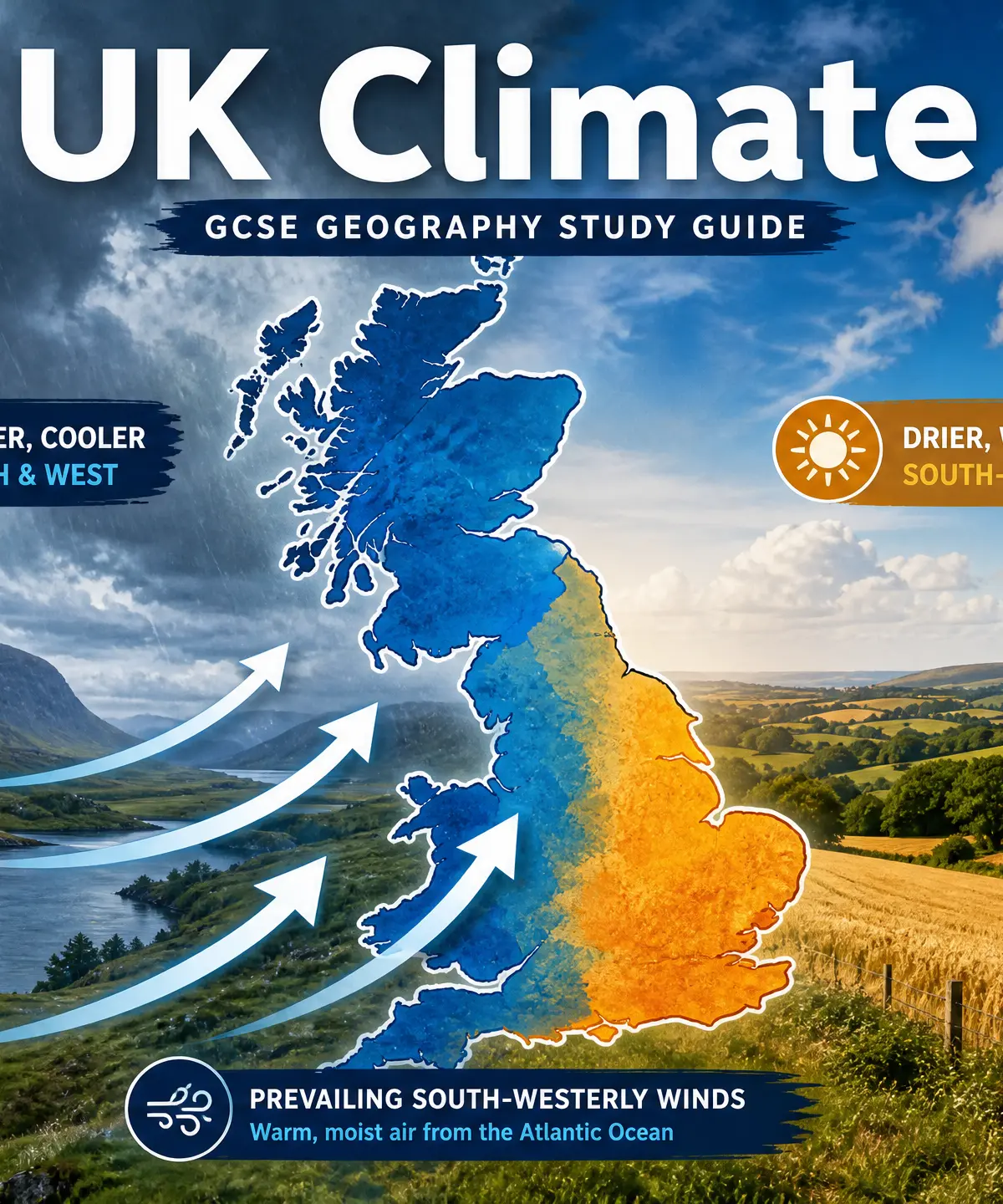
Master the intricacies of the UK's temperate maritime climate and secure top marks. This guide explores the four key factors shaping our weather, historical climate shifts over the last 1000 years, and crucial spatial variations across the country.
- 6 min read
- 3 worked examples
- 5 practice questions
- 6 key terms
Study Notes
Overview
The UK's climate is a core component of GCSE Geography, frequently appearing in exam papers across all major boards. Examiners expect candidates to move beyond simplistic descriptions of 'wet and cold' to demonstrate a nuanced understanding of spatial variation and the specific geographic factors that cause it. This topic requires you to understand the UK's current temperate maritime climate, explain the processes that drive it (Latitude, Maritime influence, Prevailing winds, Relief), and analyze how the climate has changed over the last 1000 years, from the Medieval Warm Period to modern anthropogenic warming.
To achieve Level 3 and Level 4 marks, you must use precise geographical terminology (e.g., 'orographic rainfall', 'thermal capacity') and support your explanations with specific named examples and data points.
Listen to our revision podcast for an audio summary of the key concepts:

Key Factors Influencing UK Climate
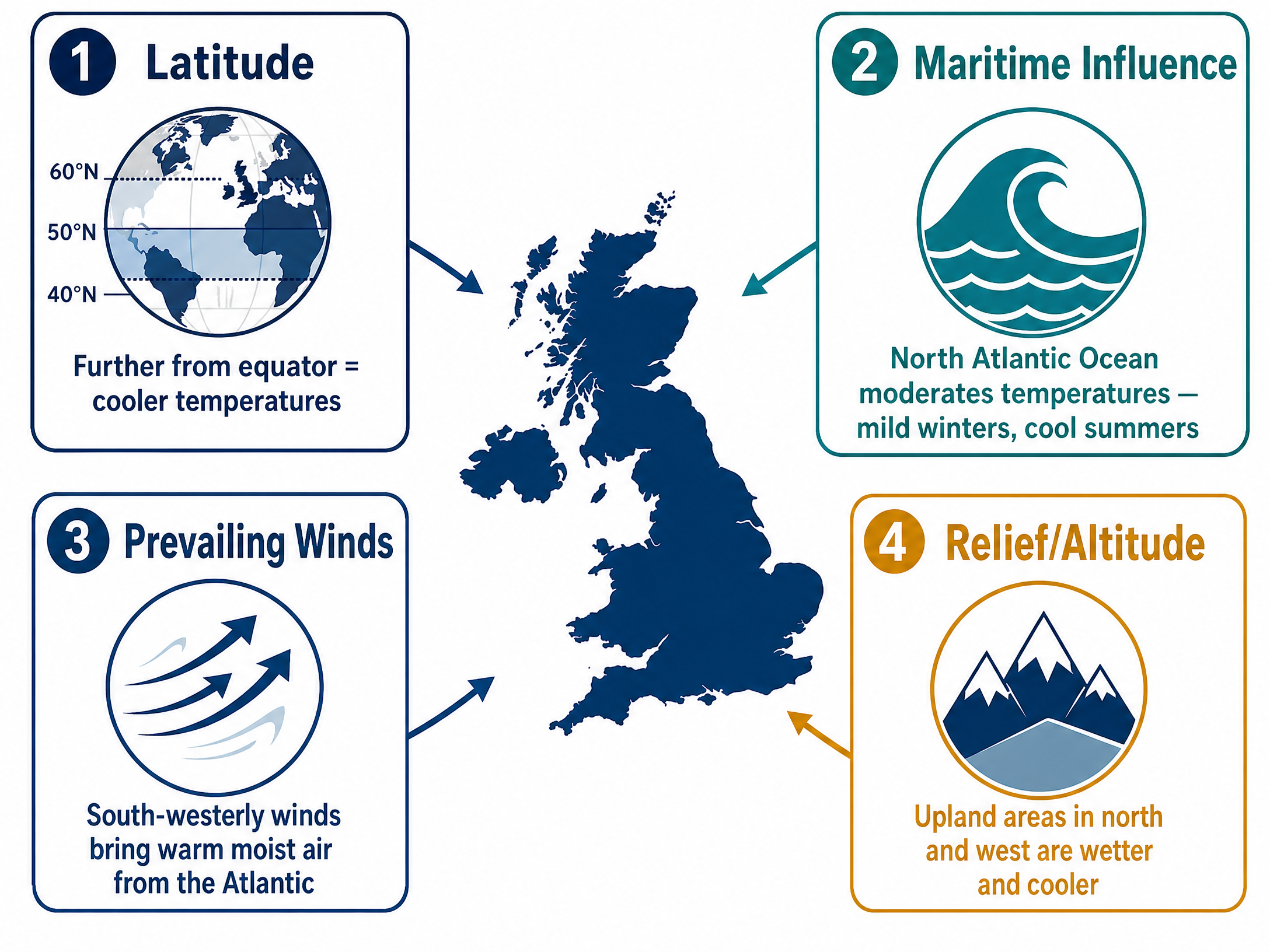
The UK's climate is driven by four primary factors. Remember the acronym LMPR.
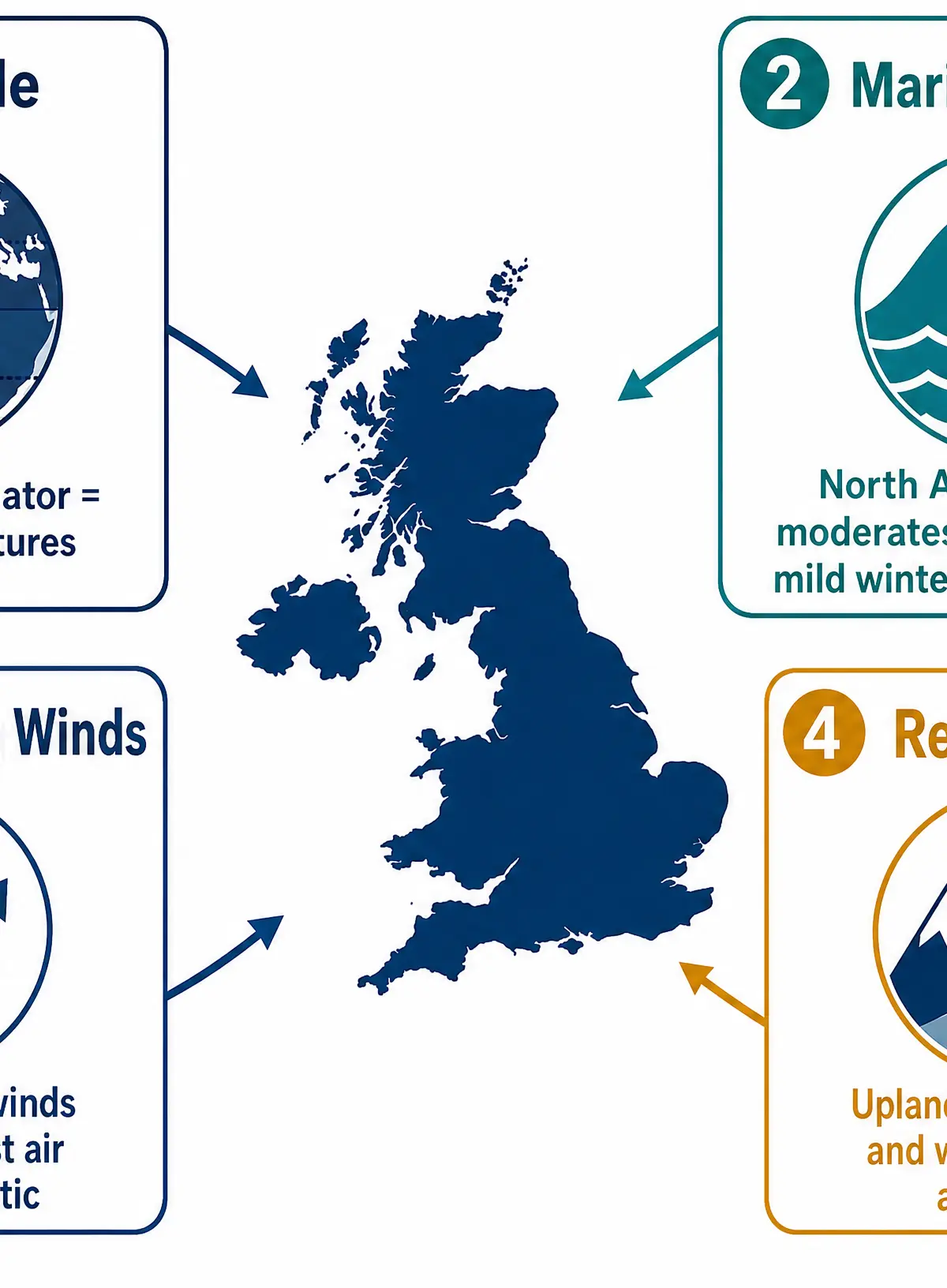
Latitude
What it is: The UK is located between roughly 50°N and 60°N.
The effect: Because we are relatively far from the equator, the sun's rays hit the earth at a lower angle, spreading solar energy over a larger area. This results in cooler temperatures compared to equatorial regions.
Spatial variation: Temperatures generally decrease as you move further north within the UK (e.g., Scotland is cooler than southern England).
Maritime Influence
What it is: The UK is an island nation surrounded by water, most notably the North Atlantic Ocean.
The effect: Water has a high thermal capacity—it heats up and cools down much more slowly than land. In winter, the ocean releases stored heat, keeping the UK milder than continental areas at similar latitudes (like Moscow). In summer, the cooler ocean prevents temperatures from soaring. This creates a 'temperate' climate without extreme temperature ranges.
Prevailing Winds
What it is: The most frequent wind direction. For the UK, this is from the south-west.
The effect: South-westerly winds travel across the Atlantic Ocean, picking up significant moisture. When they reach the UK, they bring this moisture, resulting in frequent rainfall. Because they originate over relatively warm water, they also bring mild air.
Relief (Altitude)
What it is: The physical shape of the land, particularly mountains and hills.
The effect: The UK's highest land (e.g., Scottish Highlands, Snowdonia) is located in the north and west. When moist south-westerly winds hit these uplands, the air is forced to rise, cool, and condense, causing heavy orographic (relief) rainfall.
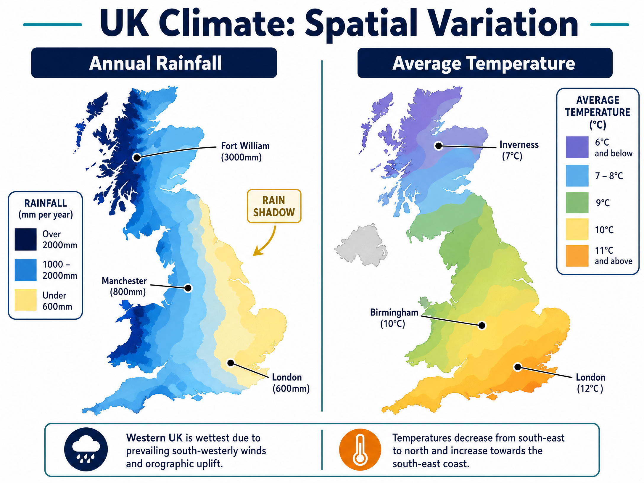
Spatial variation: The west of the UK is significantly wetter than the east, which sits in a 'rain shadow'.
Spatial Variation in the UK
Examiners heavily reward candidates who can describe and explain how climate varies across the UK.
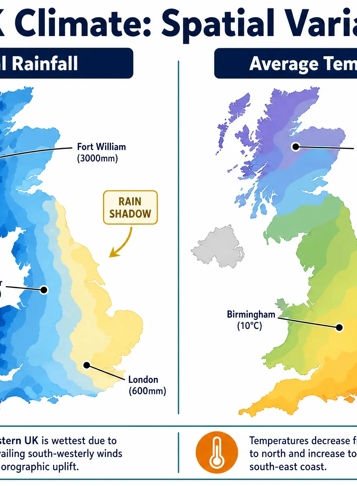
Rainfall Variation
- West/North-West: High rainfall (e.g., Fort William receives ~3000mm/year). Caused by prevailing south-westerly winds meeting upland areas, leading to relief rainfall.
- East/South-East: Lower rainfall (e.g., London receives ~600mm/year). This area is in the rain shadow of the western hills and mountains.
Temperature Variation
- North: Cooler overall due to higher latitude (lower angle of insolation).
- South: Warmer overall due to lower latitude.
- Summer vs Winter: In summer, the south-east is warmest. In winter, the west coast is mildest due to the warming influence of the North Atlantic Drift (Gulf Stream).
Climate Change Over the Last 1000 Years
Candidates must be able to describe historical climate shifts using specific evidence.
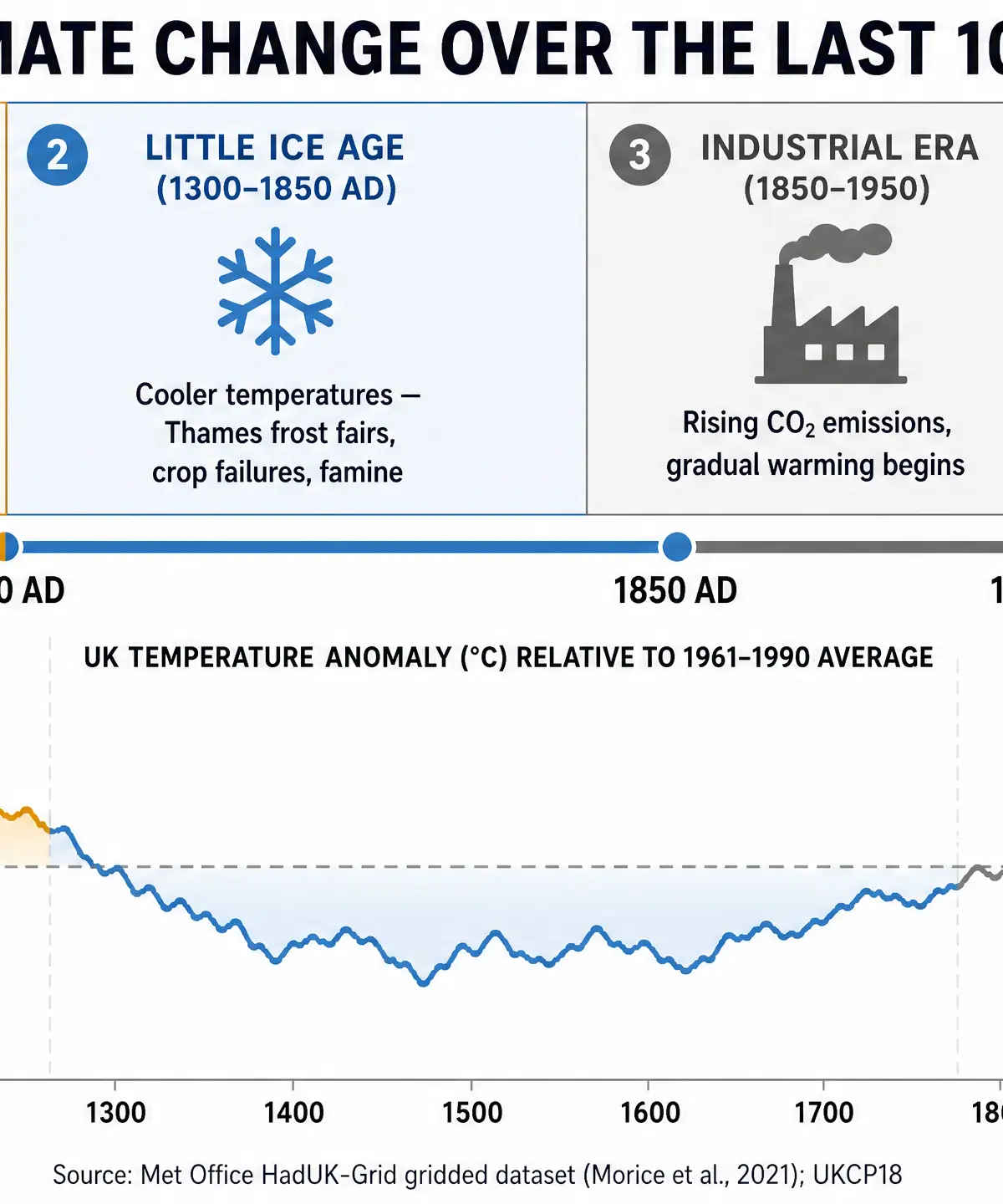
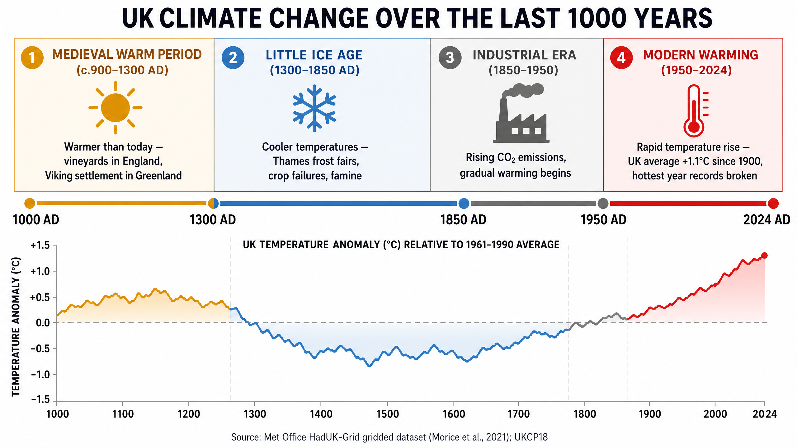
The Medieval Warm Period (c. 900–1300 AD)
What happened: A period of warmer-than-average temperatures across the Northern Hemisphere.
Evidence: Historical records show vineyards thriving in southern England, producing wine comparable to French varieties. Viking settlements were established in Greenland, indicating reduced sea ice and milder conditions.
The Little Ice Age (c. 1300–1850 AD)
What happened: A significant cooling period.
Evidence: The River Thames in London frequently froze solid enough to host 'Frost Fairs' (the last in 1814). Widespread crop failures led to famine across Europe. Glaciers in regions like the Alps and Scotland advanced significantly.
Modern Warming (1850–Present)
What happened: Rapid temperature increases driven by anthropogenic (human-caused) greenhouse gas emissions following the Industrial Revolution.
Evidence: Instrumental temperature records show the UK's average temperature has risen by ~1.1°C since 1900. Extreme weather events are increasing; 2022 saw the UK record its highest ever temperature of 40.3°C in Coningsby.
Source Skills and Data Analysis
In Geography Paper 3 (or data response questions in Papers 1/2), you will likely be asked to interpret climate graphs or maps.
- Climate Graphs: Remember that the red line shows temperature (°C) and the blue bars show rainfall (mm).
- Isoline Maps: Lines joining areas of equal temperature (isotherms) or rainfall (isohyets). Look for the overall pattern before focusing on anomalies.
Visual Resources
3 diagrams and illustrations
Interactive Diagrams
1 interactive diagram to visualise key concepts
Conceptual Flow Outline
The process of Relief Rainfall and the Rain Shadow effect
Worked Examples
3 worked examples — open one to explore the question and available guidance.
Practice Questions
Test your understanding — click to reveal model answers
Explain why the west of the UK receives more rainfall than the east. (4 marks)
Hint: Think about the direction the wind comes from and what happens when it hits mountains.
State two pieces of evidence that the UK experienced a 'Little Ice Age'. (2 marks)
Hint: What happened to the River Thames? What happened to farming?
Describe the spatial variation in temperature across the UK. (3 marks)
Hint: Look at north vs south, and mention the impact of latitude.
To what extent is maritime influence the most important factor in shaping the UK's climate? (9 marks)
Hint: Discuss maritime influence, but also evaluate the importance of latitude, relief, and prevailing winds.
Outline the evidence for the Medieval Warm Period in the UK. (2 marks)
Hint: What could farmers grow in England during this time that they usually couldn't?