Pearson Edexcel · GCSE · Geography
There are geological variations within the UK
This topic explores the incredible geological diversity of the UK, from the rugged granite peaks of the Scottish Highlands to the gentle chalk hills of southern England. Understanding how ancient tectonic events and different rock types shape our physical landscape is crucial for explaining the distinct north-west to south-east geographical divide in the UK.
- 6 min read
- 3 worked examples
- 5 practice questions
- 6 key terms
Study Notes
Overview
The UK's landscape is fundamentally determined by its geology. The distribution of different rock types—igneous, sedimentary, and metamorphic—creates a distinct pattern across the country, largely dividing the UK into upland areas in the north and west, and lowland areas in the south and east. Examiners expect candidates to be able to identify the three main rock types, explain their formation processes, provide named UK examples, and crucially, link these rock types to the landscapes they create. You must also understand how past tectonic processes, such as ancient orogenies (mountain-building periods), have folded, faulted, and uplifted these rocks to shape the dramatic relief we see today.
Audio Revision: The Geography Podcast
Listen to our comprehensive 10-minute audio guide covering the core concepts, exam tips, and a quick-fire recall quiz:

Key Rock Types and Characteristics
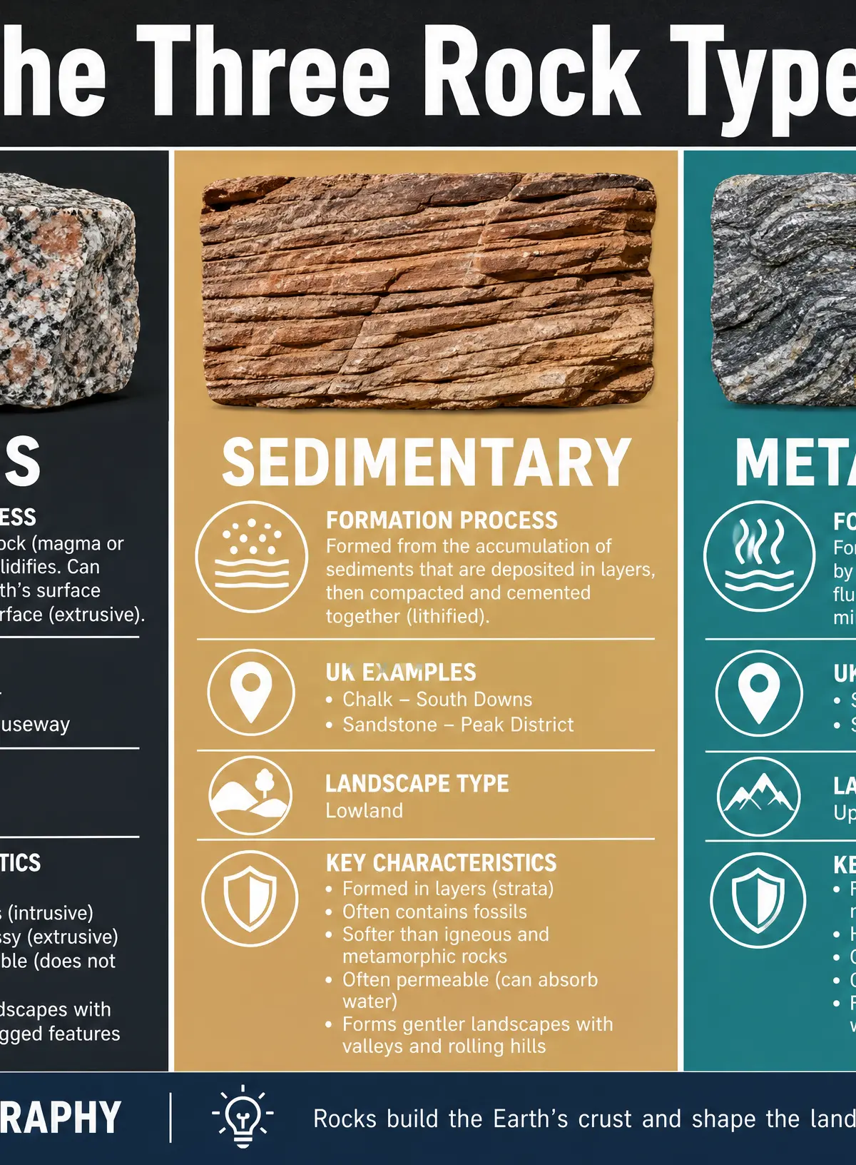
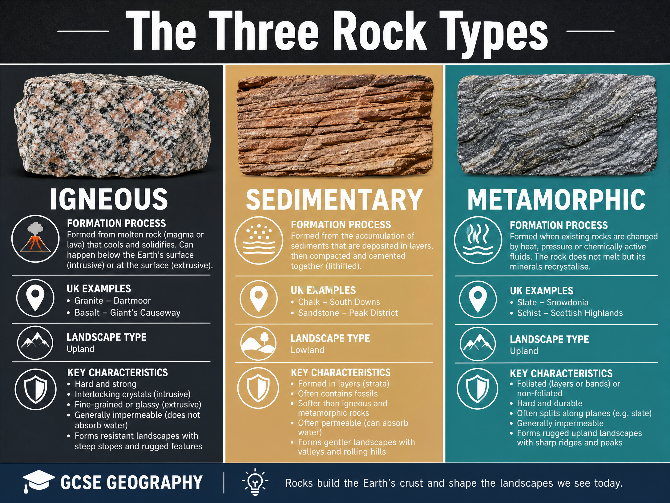
1. Igneous Rocks
Formation: Formed when molten rock (magma or lava) cools and solidifies.
- Intrusive: Magma cools slowly underground, forming large crystals (e.g., granite).
- Extrusive: Lava cools quickly above ground, forming small crystals (e.g., basalt).
Characteristics: Hard, strong, interlocking crystals. Generally impermeable (does not let water pass through easily) and highly resistant to erosion.
Landscape Impact: Forms rugged, steep upland landscapes. Often features tors (exposed blocks of rock) on moorlands.
Named Examples:
- Granite: Dartmoor (Devon), Bodmin Moor (Cornwall), Cairngorms (Scottish Highlands)
- Basalt: Giant's Causeway (Northern Ireland)
2. Metamorphic Rocks
Formation: Formed when existing rocks (igneous or sedimentary) are subjected to intense heat and/or pressure, causing them to recrystallise without melting. This usually occurs deep underground during tectonic collisions.
Characteristics: Very hard and resistant. Often foliated (arranged in bands or layers) and can split along distinct planes (cleavage).
Landscape Impact: Forms high, rugged upland landscapes, often with sharp ridges and peaks.
Named Examples:
- Slate (formed from mudstone/shale): Snowdonia (Wales)
- Schist (formed under higher pressure): Scottish Highlands
3. Sedimentary Rocks
Formation: Formed from the accumulation of sediment (rock fragments, minerals, or organic matter like shells) that is deposited in layers, compacted, and cemented together over millions of years (lithification).
Characteristics: Formed in distinct layers called strata. Often contains fossils. Generally softer and less resistant to erosion than igneous or metamorphic rocks. Many types are permeable (allow water to pass through) or porous (contain air spaces that hold water).
Landscape Impact: Forms gentler, rolling lowland landscapes with valleys and escarpments (hills with a steep scarp slope and a gentle dip slope).
Named Examples:
- Chalk (soft, white, porous limestone): South Downs, North Downs, Chiltern Hills, White Cliffs of Dover
- Sandstone (harder sedimentary rock): Pennines, Peak District
- Clay (soft, impermeable): London Basin, Vale of York
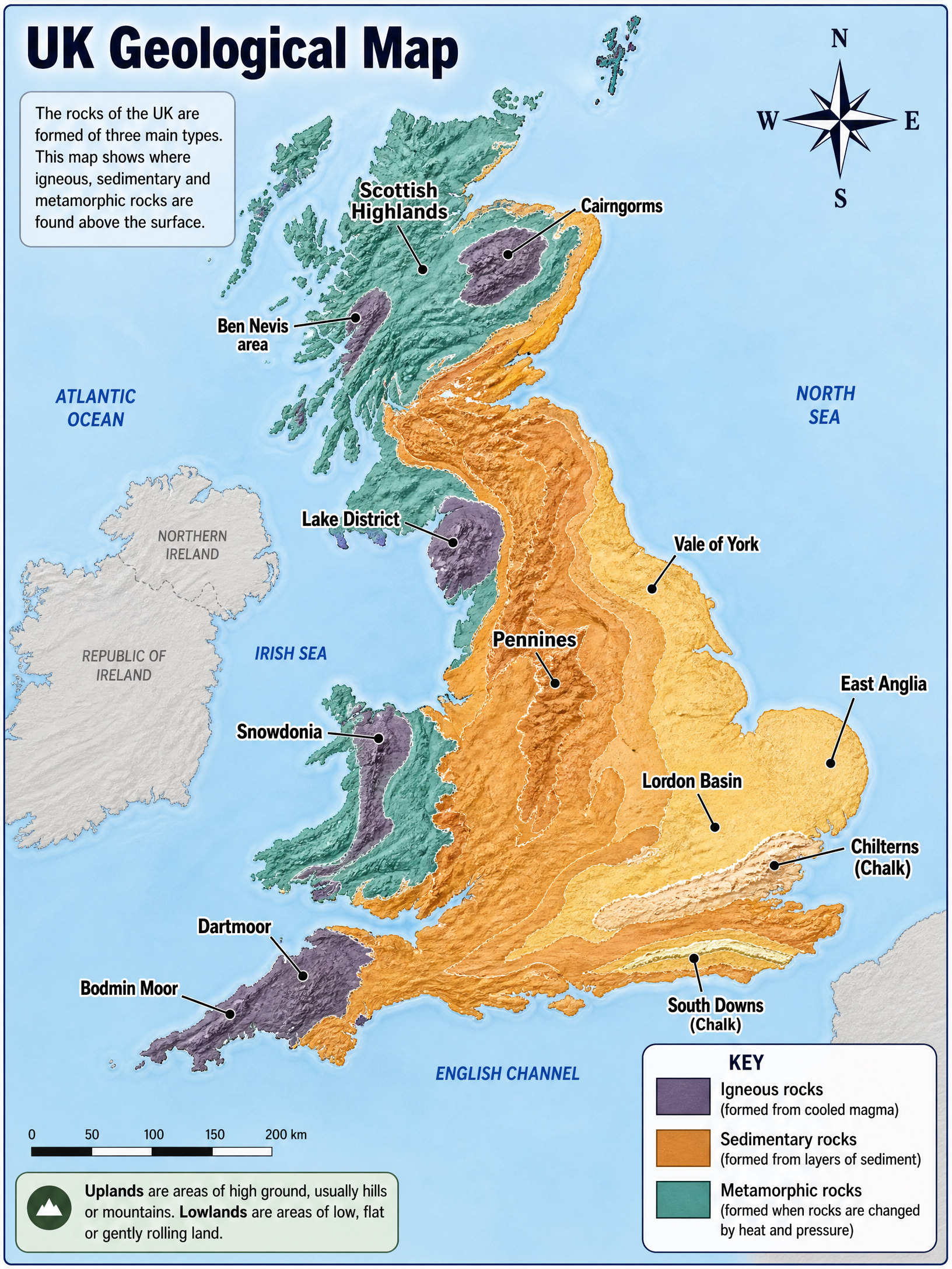
The UK Geological Map
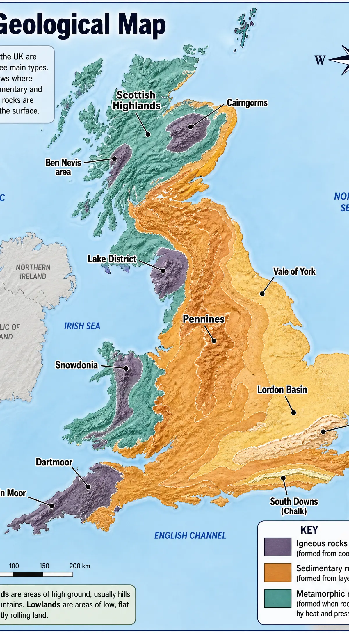
The distribution of these rocks creates a clear geographical divide:
- North and West: Dominated by older, harder igneous and metamorphic rocks, creating upland landscapes.
- South and East: Dominated by younger, softer sedimentary rocks, creating lowland landscapes.
The Tees-Exe line is an imaginary line drawn between the mouth of the River Tees in the northeast and the River Exe in the southwest. It roughly divides the upland and lowland areas of the UK.
The Role of Past Tectonic Processes
The UK is not currently located on a tectonic plate boundary, but its rocks bear the scars of massive ancient tectonic events that shaped the landscape.
The Caledonian Orogeny (approx. 490-390 million years ago)
What happened: The collision of ancient continents caused massive folding, faulting, and uplift of rocks in what is now Scotland, northern England, and Wales.
Why it matters: This created the ancient mountain chains that form the backbone of the UK's uplands today. The intense pressure during this collision also caused widespread regional metamorphism, creating the slate and schist found in these areas.
The Variscan Orogeny (approx. 360-300 million years ago)
What happened: Another major continental collision affected southern areas of the UK, particularly southwest England and South Wales.
Why it matters: This caused further folding of rocks and the intrusion of massive bodies of magma (batholiths) deep underground. Over millions of years, the softer rocks above were eroded away, exposing these hard granite intrusions as the upland moorlands of Dartmoor and Bodmin Moor.
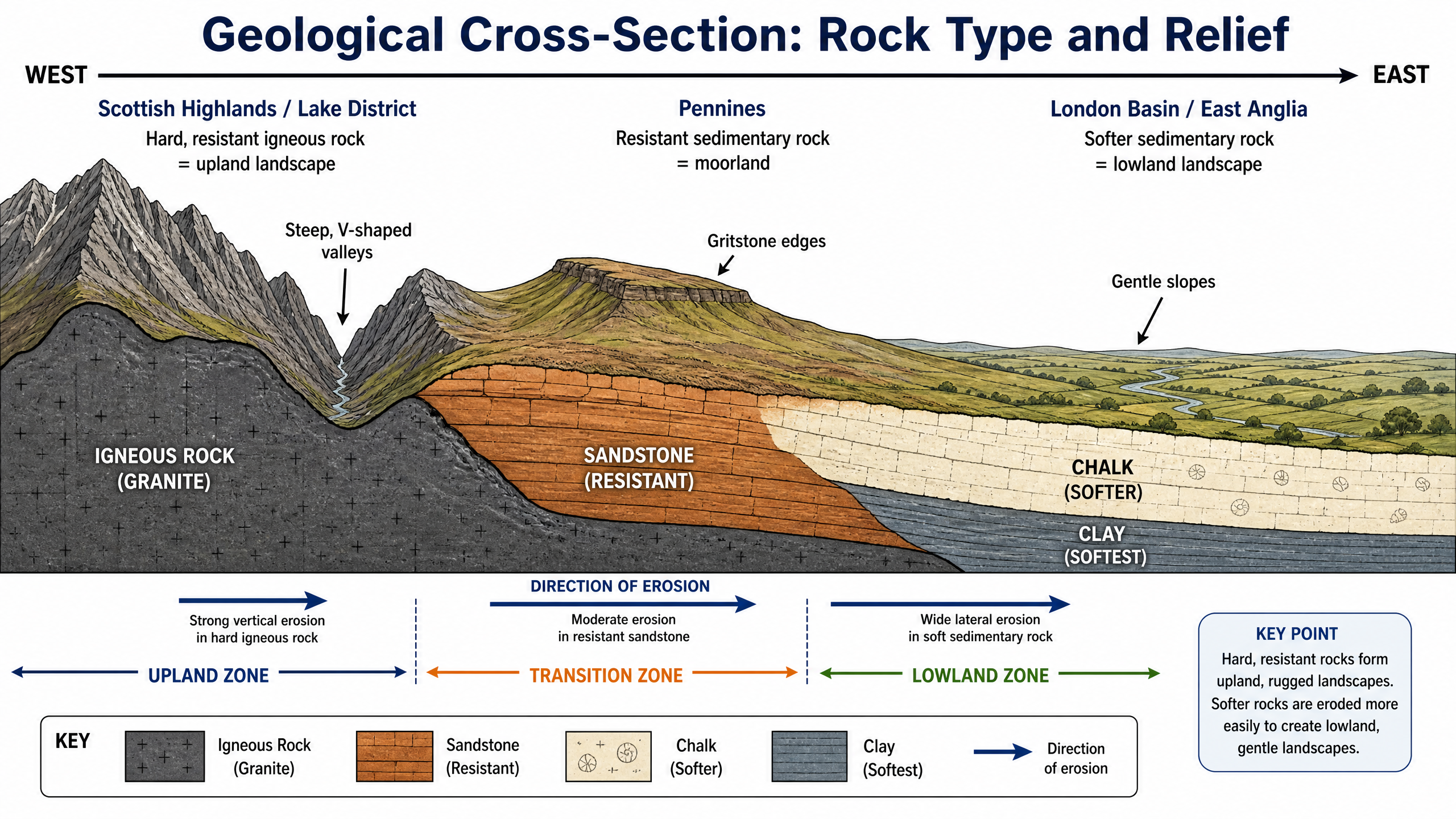
Geological Cross-Section: Upland to Lowland
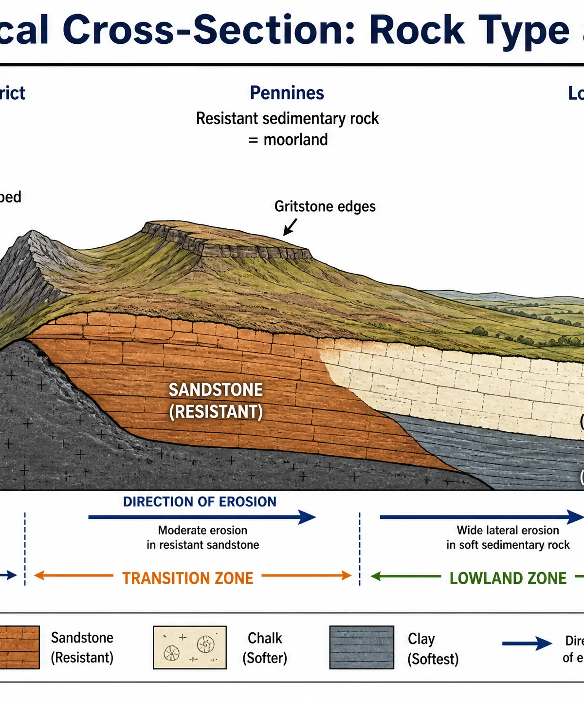
Examiners often use cross-sections to test your understanding of how geology affects relief (the shape of the land).
- Upland Zone (e.g., Lake District): Hard igneous/metamorphic rocks resist erosion, maintaining high elevation and steep slopes.
- Transition Zone (e.g., Pennines): More resistant sedimentary rocks like gritstone and harder sandstones form elevated moorlands and distinct edges.
- Lowland Zone (e.g., London Basin): Alternating bands of softer sedimentary rocks (chalk and clay) form gentle hills (escarpments) and wide, flat vales.
Visual Resources
3 diagrams and illustrations
Interactive Diagrams
1 interactive diagram to visualise key concepts
Conceptual Flow Outline
The Rock Cycle showing how the three rock types interact.
Worked Examples
3 worked examples — open one to explore the question and available guidance.
Practice Questions
Test your understanding — click to reveal model answers
State one characteristic of sedimentary rock.
Hint: Think about how it is formed in water.
Explain how past tectonic processes have influenced the physical landscape of the UK. (4 marks)
Hint: Mention an orogeny and what it did to the rocks.
Compare the characteristics and landscapes associated with granite and chalk in the UK. (6 marks)
Hint: Structure your answer by comparing their hardness, permeability, and resulting relief.
Explain the formation of metamorphic rocks. (3 marks)
Hint: What are the two key ingredients for metamorphism?
Outline the relationship between rock type and relief in the UK. (4 marks)
Hint: Relief means the height and shape of the land. Connect hard/soft rocks to high/low land.