OCR · GCSE · History
Course version: J410 · Version from Mar 2026
Form and Function c.1000–1750 (J410/12 and J410/13) - The location of…
Full specification wording
Castles: Form and Function c.1000–1750 (J410/12 and J410/13) - The location of Kenilworth Castle: The evidence used by historians, e.g. maps from medieval to modern times, drawings in local histories.
Historians reconstruct where Kenilworth Castle stood and how its setting changed by combining several kinds of evidence rather than trusting one source.
Checked against the OCR J410 specification (opens in a new tab) on .
- Point 4 of 4
- 3 key terms
Study notes
From the checked teaching notes for this specification point.
The idea
Historians reconstruct where Kenilworth Castle stood and how its setting changed by combining several kinds of evidence rather than trusting one source. Maps are especially useful: a medieval map may show the castle mound and nearby settlement, while later maps from the modern period record roads, the mere and the expanding parkland, so comparing maps across time reveals change in the landscape around the site. Drawings printed in local histories add visual detail about walls, towers and water features, though they may be romanticised or inaccurate. A strong answer identifies the type of evidence, states what it can show about the castle's location, and recognises its limits, such as a map's date or a drawing's purpose.
What earns the marks
- Identifies maps as evidence that shows the castle's position and its changing surroundings across time.
- Explains that comparing maps from the medieval period with modern maps reveals how the landscape around Kenilworth altered.
- Recognises that drawings in local histories can show layout and setting but may be unreliable or idealised.
- States a limitation of a source, such as its date, purpose or accuracy, when judging its value for locating the castle.
Common mistakes and how to put them right
Treats a single map as complete proof of the castle's location.
Put it right: Combine several maps and drawings and weigh their reliability.
Assumes drawings in local histories are photographs of the site.
Put it right: Question their purpose and accuracy before relying on them.
Ignores the date of a map when judging it.
Put it right: Match each source to the period it actually records.
Exam tips
- Name the type of evidence first, then say what it shows about the castle's location.
- Compare at least two maps from different periods to show change over time.
- Add one sentence on the limits of the evidence to reach the higher marks.
Try the lesson
The start of the Castles: Form and Function c.1000–1750 (J410/12 and J410/13) - The location of Kenilworth Castle: The evidence used by historians, e.g. maps from medieval to modern times, drawings in local histories. lesson, made from checked teaching notes for this specification point.
Have a go first
Which type of source would a historian use to see how the layout of Kenilworth Castle changed over several centuries?
Listen
Historians reconstruct where Kenilworth Castle stood and how its setting changed by combining several kinds of evidence rather than trusting one source. Maps are especially useful: a medieval map may show the castle mound and nearby settlement, while later maps from the modern period record roads, the mere and the expanding parkland, so comparing maps across time reveals change in the landscape around the site. Drawings printed in local histories add visual detail about walls, towers and water features, though they may be romanticised or inaccurate. A strong answer identifies the type of evidence, states what it can show about the castle's location, and recognises its limits, such as a map's date or a drawing's purpose. A strong answer earns marks for these points. Identifies maps as evidence that shows the castle's position and its changing surroundings across time. Explains that comparing maps from the medieval period with modern maps reveals how the landscape around Kenilworth altered. Recognises that drawings in local histories can show layout and setting but may be unreliable or idealised. States a limitation of a source, such as its date, purpose or accuracy, when judging its value for locating the castle. Exam tip: Name the type of evidence first, then say what it shows about the castle's location.
See it
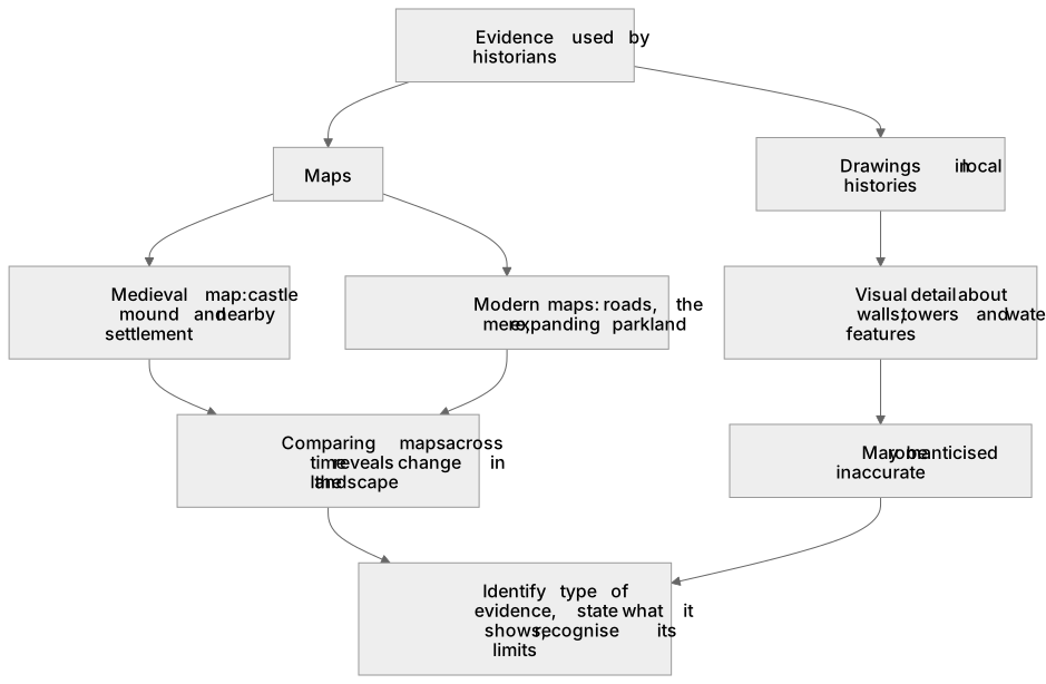
Key words
Say what each word means before you turn the card.
Maps as evidence of location and change
Try answering aloud or in your head before turning the card.
Drawings in local histories
Try answering aloud or in your head before turning the card.
Judging reliability and usefulness of sources
Try answering aloud or in your head before turning the card.
See every definition
- Maps as evidence of location and change
- Maps are especially useful evidence: comparing maps across time reveals change in the landscape around the site.
- Drawings in local histories
- Drawings printed in local histories add visual detail about walls, towers and water features, though they may be romanticised or inaccurate.
- Judging reliability and usefulness of sources
- A strong answer identifies the type of evidence, states what it can show about the castle's location, and recognises its limits.
Label the diagram
Some boxes have lost their names. Pick the right name for each number.
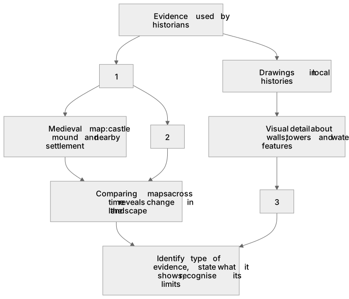
1Box 1
2Box 2
3Box 3
There is more to this lesson
The full lesson goes on to check your understanding and help you earn the marks. Create a free account to carry on, with your progress saved.
A week of Premium from your first lesson · Then the free plan continues · No card, no charge
Test your understanding of Castles: Form and Function c.1000–1750 (J410/12 and J410/13) - The location of Kenilworth Castle: The evidence used by historians, e.g. maps from medieval to modern times, drawings in local histories.
Active recall beats re-reading. Take an instant quiz now to test what you’ve learned and lock it into long-term memory.
A week of Premium from your first lesson · Then the free plan continues · No card, no charge